
The Bucher's Mill Covered Bridge or Butcher's Mill Covered Bridge is a covered bridge that spans Cocalico Creek in Lancaster County, Pennsylvania, United States. After the Landis Mill Covered Bridge, it is the second shortest covered bridge in the county. A county-owned and maintained bridge, its official designation is the Cocalico #2 Bridge.

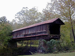
The Humpback Covered Bridge located in the U.S. state of Virginia, is one of the few remaining covered bridges in the United States that was built higher in the middle than on either end; hence the name of "humpback". The bridge was built in 1857 and is also the oldest remaining covered bridge in the state of Virginia. Its WGCB number is 46-03-01. The bridge spans a tributary of the Jackson River known as Dunlap Creek, for a distance of 109 feet (33 m). The humpback feature is 4 feet (1.2 m) higher in the center than at either end. The bridge is located near the city of Covington, Virginia.
The Waldo Covered Bridge, also known as the Riddle Mill Covered Bridge, is a privately owned wood & metal combination style covered bridge that spans Talladega Creek in Talladega County, Alabama, United States. It is located off State Route 77 just south of the town of Waldo, about 6 miles southeast of Talladega. Coordinates are 33°22′44.78″N86°01′43.87″W.

The Swann Covered Bridge, also called the Joy Covered Bridge or Swann-Joy Covered Bridge, is a county-owned, wood-and-metal combination style covered bridge that spans the Locust Fork of the Black Warrior River in Blount County, Alabama, United States. It is located on Swann Bridge Road off State Route 79, just west of the town of Cleveland, about 10 miles (16 km) northwest of Oneonta.
The Coldwater Covered Bridge, also known as the Hughes Mill Covered Bridge, is a locally owned wooden covered bridge that spans the outflow from Oxford Lake in Calhoun County, Alabama, United States. It is located at Oxford Lake Park off State Route 21 in the city of Oxford, about 4 miles south of Anniston.

The Clarkson–Legg Covered Bridge, more simply known as Clarkson Covered Bridge, is a county-owned wooden covered bridge that spans Crooked Creek in Cullman County, Alabama, United States. It is located at Clarkson Covered Bridge Park on County Road 1043 off U.S. Route 278 near the community of Bethel, about 8 mi (13 km) west of Cullman.

The Horton Mill Covered Bridge is a state-owned wooden covered bridge that spans the Calvert Prong of the Little Warrior River in Blount County, Alabama, United States. It is located on a river crossing to Ebell Road and Covered Bridge Circle, off State Route 75 about 5 miles (8.0 km) north of the city of Oneonta.
The Easley Covered Bridge, also known as the Old Easley Covered Bridge or Rosa Covered Bridge, is a county-owned wood and metal combination style covered bridge that spans Dub Branch of the Calvert Prong of the Little Warrior River in Blount County, Alabama, United States. It is located on Easley Bridge Road off U.S. Route 231, just south of the town of Rosa, about 5 miles northwest of Oneonta. Coordinates are 33°58′16″N86°31′07″W.

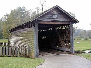
Kymulga Mill & Covered Bridge are two locally owned historic landmarks located at Kymulga Park in Talladega County, Alabama, United States. The park is on Grist Mill Road off State Route 76 about 4 miles northeast of the city of Childersburg.

The Salem-Shotwell Covered Bridge, also known as the Pea Ridge Covered Bridge, is a locally owned wooden covered bridge that spans Rocky Brook in Lee County, Alabama, United States. It is located halfway down Park Road at Opelika Municipal Park, which is off North 5th Street in the city of Opelika. Coordinates are 32°39′33.46″N85°22′52.94″W.

The Alamuchee-Bellamy Covered Bridge is a county-owned wooden covered bridge that spans the northeast corner of Duck Pond in Sumter County, Alabama, United States. It is located on the campus of the University of West Alabama behind Reed Hall, which is off Student Union Drive in the city of Livingston.
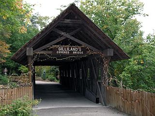
The Gilliland-Reese Covered Bridge, more simply known as Gilliland's Covered Bridge, is a locally owned wooden covered bridge that spans a small pond near Black Creek in Etowah County, Alabama, United States. It is located at Noccalula Falls Park off Noccalula Road in the city of Gadsden. Coordinates are 34°02′21.79″N86°01′26.93″W. Noccalula Falls Park is also home to the 90-foot (27 m) Noccalula Falls, part of Black Creek as it cascades down into a ravine from a ledge off Lookout Mountain. There are a couple of sources which state the bridge spans Clayton Fish Pond, but that is over a mile west of the park along a rural section of Hinds Road.

The Old Union Crossing Covered Bridge is a privately owned wood & metal combination style covered bridge that spans the West Fork of the Little River in DeKalb County, Alabama, United States. It is located on an access road between Shady Grove Dude Ranch and Cloudmont Ski & Golf Resort on Lookout Mountain, which is off County Road 614 near the town of Mentone. Coordinates are 34°32′3.51″N85°35′56.47″W.
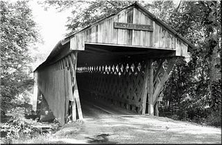
The Nectar Covered Bridge was a wood and metal combination style covered bridge which spanned the Locust Fork of the Black Warrior River in Blount County, Alabama, United States. It was located on Nectar Bridge Road off State Route 160, just east of the town of Nectar, about 14 miles northwest of Oneonta. Nectar Covered Bridge was at one time the seventh-longest covered bridge in the country. The bridge remained open to single lane motor traffic from its construction until it was burned by vandals on June 13, 1993.

The Bob White Covered Bridge, also known as the Lower Covered Bridge or Woolwine Covered Bridge, was a county-owned wooden covered bridge that spanned the Smith River in Patrick County, Virginia, United States. It was located on the old portion of Bob White Road off State Route 8 southeast of the community of Woolwine, about 13 miles north of Stuart. Coordinates were 36°46′44.82″N80°14′51.26″W.

The Jack's Creek Covered Bridge, also known as the Upper Covered Bridge, is a county-owned wooden covered bridge that spans the Smith River in Patrick County, Virginia, United States. It is located on Jack's Creek Road (SR 615) off State Route 8 just south of the community of Woolwine, about 11 miles (18 km) north of Stuart.

Buzzard Roost is an unincorporated community in Colbert County, Alabama, United States. Buzzard Roost had a post office in the 1850s, but it no longer exists.
The Lidy Walker Covered Bridge, formerly known as the Big Branch Covered Bridge, was a privately owned wood-&-metal combination style covered bridge which spanned the outlet to Lidy's Lake in Cullman County, Alabama, United States. It was located in the Berlin community at a pasture near the lake off Cullman County Road 1616 near U.S. Route 278, 6 miles east of the city of Cullman.
The Tallahatchee Covered Bridge, also known as the Prickett Covered Bridge, was a privately owned wood and metal combination style covered bridge which spanned a pond near Nances Creek in Calhoun County, Alabama, United States. It was located just off State Route 9, about 2 miles south of the city of Piedmont. Approximate coordinates were 33°53′16.13″N85°37′33.70″W.
