Oakley Wood (Warwickshire)

Last updated

Oakley Wood
United Kingdom England adm location map.svg
Red pog.svg
Location of Oakley Wood in Warwickshire
Type Nature reserve
Location Bishop's Tachbrook, Warwickshire, England
Coordinates 52°13′51″N01°33′9″W / 52.23083°N 1.55250°W / 52.23083; -1.55250
Area47 ha (116.14 acres)
Owned by Warwick District Council
Operated by Warwickshire Wildlife Trust
OpenAll year

Oakley Wood is a 47 hectare (116 acre) woodland with public access situated south of Leamington Spa in Warwickshire, close to the village of Bishop's Tachbrook. The wood is a Plantation on Ancient Woodland Site (PAWS); [1] [2] that is, a site which has been continuously wooded since at least 1600, but which has more recently had much of the native broad-leaved trees felled and replaced with a commercial conifer crop. Records of the wood date back to 12th century, and it contains a scheduled ancient monument known as Oakley Wood Camp.

Contents

The wood was purchased by Warwick District Council in 2008 to allow public access after it was put up for sale by its private owners. The District Council works in partnership with Warwickshire Wildlife Trust and the Friends of Oakley Wood to ensure it is managed sustainably for the benefit of local people and wildlife.

History

Oakley Wood is old. The earliest recorded mention of the wood is in a 12th-century record granting part of the wood of Acle (an old name for Oakley) to an abbey in Worcestershire. There is evidence to suggest that at least part of the wood had already been enclosed by the late 13th century. The substantial woodbank that surrounds the wood has an external ditch typical of an ancient coppice wood. [3] In medieval times wood was a valuable resource, and the woodbanks were in place to indicate ownership and provide protection.

In the 1950s much of the ancient woodland was clear-felled and replaced with a commercial conifer crop, which was never harvested. However, many old and veteran trees remain, especially on the boundary banks and in the southernmost part of the wood.

Nature

Oakley Wood is managed as a nature reserve by Warwickshire Wildlife Trust on behalf of Warwick District Council. A long term management plan [4] is in place to return the wood to a more natural mixed-deciduous environment. Many of the old commercially-planted conifers have been removed and replanting of deciduous trees and shrubs undertaken. The wood has flora typical of ancient woodland, with bluebells, wood anemone and celandine showing during the spring.

The wood is inhabited by roe deer, muntjac and the occasional fallow deer, as well as badgers, foxes and a wide variety of birds. [5] Mike Slater of the Butterfly Conservation wrote in 2014 that "Oakley Wood is an important butterfly site containing 70% of Warwickshire’s butterfly species", [6] including White Admiral and Silver-washed Fritillary. A BioBlitz conducted in 2014 found 221 different species. [7]

The Earthworks

Veteran tree on boundary bank, Oakley Wood Coppiced oak on wood bank.jpg
Veteran tree on boundary bank, Oakley Wood

The wood is surrounded by boundary banks, or woodbanks, most substantially in the northern parts. [8] They are typical of medieval wood boundaries, with many veteran trees, mostly coppiced oak, growing on top of the banks. References in historic documents suggest that the banks were created sometime in the 13th century. Lesser earthworks surround much of the rest of the wood to the south, which is believed was a separate wood called Moreton Close at the time of the original enclosure. There is also evidence of more modern earthworks in the form of drainage ditches. [9]

Within the boundary banks are inner earthworks known as Oakley Wood Camp. The boundary banks and the camp earthworks are interconnected.

The camp is a designated Scheduled Monument. [10]

Oakley Wood Camp

Oakley Wood Camp, c. 1875 Oakley Wood Camp 1875.png
Oakley Wood Camp, c. 1875

The camp is a 3.8 hectare (9.4 acre) area enclosed by earthworks or embankments with ditches, which are generally of an approximate overall height of 2m and overall width of 10m, but can reach 3m and 12m respectively in the most substantial NE section. It is considered to be at least medieval, and possibly much older.

The oldest documented evidence of the camp is in a survey published in a history of Warwickshire in 1904, along with a map described as "about AD 1875, after Burgess" . The survey mentions that local lore held that the camp was Roman but without any evidence to support this. [11]

There are conflicting theories about the origin of the camp.

Iron Age fort

The 1904 survey of the camp is listed under "Defensive Earthworks", describing it as a stronghold that "more or less resembles some of the works of class B" (a hilltop fortress). [11] Historic England designates it a "slight univallate hillfort", of either Iron Age or Bronze Age origin. [10] [12] Archeological opinion is that the "substantial" nature of the earthworks indicates a defensive purpose, although medieval woodbanks can be equally massive. [13]

At one time the outer earthworks were thought to be outer defences of the hillfort but this idea has been discarded. [10]

Medieval Woodland Management

In 1986, Richard Hingley, for the Warwickshire Museum, surveyed the site and suggested that the earthworks could be medieval, possibly a woodland management system for enclosure or drainage. [14] [15] [16] The Iron Age theory is called into question by atypical features of the camp compared with those expected of a hillfort: its unusual shape, questionable strategic position and the lack of a defensible entrance.

Oliver Rackham, the noted expert on ancient English woodland, has observed that internal woodbanks can occur in woods where they record the division between two contiguous woods, or subdivisions of the wood between owners over time. [13]

Pottery find

In 2022 a sherd of pottery was discovered protruding from one of the banks, the only ancient artefact known to have been found on the site. It was initially thought to be medieval, but an archaeological specialist for the Warwick Museum identified it as most likely being from the neck of a Roman amphora. This strengthens the Iron Age fort origin as the Romans were known to repurpose existing fortifications. The sherd is held by the Warwick Museum.

The find is potentially related to other Iron Age/Romano activity which has been found in the nearby Barford area [17]

Related Research Articles

<span class="mw-page-title-main">Arden, Warwickshire</span> The Forest of Arden, territory in the West Midlands

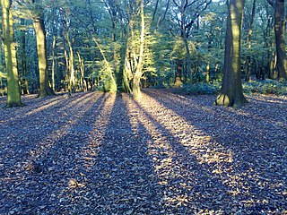
The Forest of Arden is a former forest and culturally defined area located in the English West Midlands, that in antiquity and into the Early Modern Period included much of Warwickshire, and parts of Shropshire, Staffordshire, the West Midlands, and Worcestershire. It is associated with William Shakespeare as a territory of his youth, and the setting of some of his drama.

<span class="mw-page-title-main">Badbury Rings</span> Iron Age hill fort in east Dorset, England

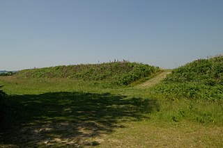
Badbury Rings is an Iron Age hill fort and Scheduled Monument in east Dorset, England. It was in the territory of the Durotriges. In the Roman era a temple was located immediately west of the fort, and there was a Romano-British town known as Vindocladia a short distance to the south-west.

<span class="mw-page-title-main">History of Warwickshire</span>

This is about the history of the County of Warwick situated in the English Midlands. Historically, bounded to the north-west by Staffordshire, by Leicestershire to the north-east, Northamptonshire to the east, Worcestershire to the west, Oxfordshire to the south, Gloucestershire to the south-west, an exclave of Derbyshire to the far north, and less than 400 yards from the border with Shropshire in the far west.

<span class="mw-page-title-main">Baginton</span> Human settlement in England

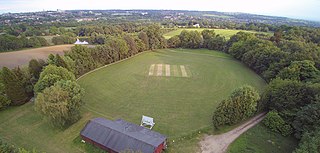
Baginton is a village and civil parish in the Warwick district of Warwickshire, England, and has a common border with the City of Coventry / West Midlands county. With a population of 801, Baginton village is 4 miles (6.4 km) south of central Coventry, 4.5 miles (7.2 km) northeast of Kenilworth and 7 miles (11 km) north of Leamington Spa. The population had reduced slightly to 755 at the 2011 Census. The Lucy Price playing field is situated centrally in the village.

<span class="mw-page-title-main">Coldfall Wood</span> Ancient woodland in Muswell Hill, North London

Coldfall Wood is an ancient woodland in Muswell Hill, North London. It covers an area of approximately 14 hectares and is surrounded by St Pancras and Islington Cemetery, the East Finchley public allotments, and the residential streets Creighton Avenue and Barrenger Road. It is the site of the discoveries which first led to the recognition that glaciation had once reached southern England. It was declared a local nature reserve in 2013, and is also a Site of Borough Importance for Nature Conservation, Grade 1.

<span class="mw-page-title-main">Highgate Wood</span> An ancient woodland in North London

Highgate Wood is a 28 hectare area of ancient woodland in North London, lying between East Finchley, Highgate and Muswell Hill. It was originally part of the ancient Forest of Middlesex which covered much of London, Hertfordshire and Essex and was mentioned in the Domesday Book. It lies in the London Borough of Haringey, but is owned and managed by the City of London Corporation.

<span class="mw-page-title-main">Poynings</span> Village and civil parish in West Sussex, England

Poynings is a village and civil parish in the Mid Sussex District of West Sussex, England. The parish lies wholly with the South Downs National Park. To its south is Brighton and Hove, to its west is the Fulking parish, to its east is the Newtimber parish and to its north is Albourne parish. The planning authority for Poynings is the South Downs National Park Authority (SDNPA), the statutory planning authority for the National Park area.

<span class="mw-page-title-main">Leigh Woods National Nature Reserve</span> National nature reserve near Bristol, England

Leigh Woods is a 2-square-kilometre (0.77 sq mi) area of woodland on the south-west side of the Avon Gorge, close to the Clifton Suspension Bridge, within North Somerset opposite the English city of Bristol and north of the Ashton Court estate, of which it formed a part. Stokeleigh Camp, a hillfort thought to have been occupied from the third century BC to the first century AD and possibly also in the Middle Ages, lies within the reserve on the edge of the Nightingale Valley. On the bank of the Avon, within the reserve, are quarries for limestone and celestine which were worked in the 18th and 19th centuries are now derelict.

<span class="mw-page-title-main">Worlebury Hill</span>

Worlebury Hill is the name given to an upland area lying between the flatlands of Weston-super-Mare and the Kewstoke area of North Somerset, England. Worlebury Hill's rises from sea level to its highest point of 109 metres (358 ft), and the western end of the hill forms a peninsula, jutting out into the Bristol Channel, between Weston Bay and Sand Bay. A toll road follows the coast around the hill from Sand Bay in the north to the now derelict Birnbeck Pier in the west, although tolls are not currently collected on the road. Worlebury Golf Club is situated on the Hill and the area is known for being one of the wealthiest areas in the county of Somerset.

<span class="mw-page-title-main">Dolebury Warren</span> Hillfort in North Somerset

Dolebury Warren is a 90.6 hectares biological Site of Special Scientific Interest (SSSI) and ancient monument near the villages of Churchill and Rowberrow in North Somerset, part of South West England. It is owned by the National Trust, who acquired the freehold in 1983, and managed by the Avon Wildlife Trust.

<span class="mw-page-title-main">Weston Big Wood</span> Woodland near Portishead, England

Weston Big Wood is a 37.48 hectare woodland west of the town of Portishead, North Somerset, England. It is a nature reserve and biological Site of Special Scientific Interest, notified in 1971. The wood takes its name from the nearby village of Weston-in-Gordano.

Prideaux Castle is a multivallate Iron Age hillfort situated atop a 133 m (435 ft) high conical hill near the southern boundary of the parish of Luxulyan, Cornwall, England, United Kingdom. It is also sometimes referred to as Prideaux Warren, Prideaux War-Ring, or Prideaux Hillfort. The site is a scheduled monument and so protected from unauthorised works by the Ancient Monuments and Archaeological Areas Act 1979.

<span class="mw-page-title-main">Boringdon Camp</span>

Boringdon Camp is an English Iron Age and Roman earthwork in Cann Woods, near Plympton, Plymouth, Devon. It is a scheduled ancient monument and owned by South Hams District Council.

<span class="mw-page-title-main">English Lowlands beech forests</span> Ecoregion in the British Isles

The English Lowlands beech forests is a terrestrial ecoregion in the United Kingdom, as defined by the World Wide Fund for Nature (WWF) and the European Environment Agency (EEA). It covers 45,600 km2 (17,600 sq mi) of Southern England, approximately as far as the border with Devon and South Wales in the west, into the Severn valley in the north-west, into the East Midlands in the north, and up to the border of Norfolk in the north-east. The WWF code for this ecoregion is PA0421.

<span class="mw-page-title-main">Grovely Wood</span> Woodlands in Wiltshire, England

Grovely Wood is one of the largest woodlands in southern Wiltshire, England. It stands on a chalk ridge above the River Wylye in Barford St Martin parish, to the south-west of the village of Great Wishford, within the Cranborne Chase and West Wiltshire Downs Area of Outstanding Natural Beauty. It is recognised for its nature conservation importance through designation as a County Wildlife Site. Among the species found here is the Purple Emperor butterfly.

<span class="mw-page-title-main">Scratchbury Camp</span> Iron Age hillfort in Wiltshire, England

Scratchbury Camp is the site of an Iron Age univallate hillfort on Scratchbury Hill, overlooking the Wylye valley about 1 km northeast of the village of Norton Bavant in Wiltshire, England. The fort covers an area of 37 acres (15 ha) and occupies the summit of the hill on the edge of Salisbury Plain, with its four-sided shape largely following the natural contours of the hill.

<span class="mw-page-title-main">Membury Camp</span> Iron Age hillfort in Wiltshire, England

Membury Camp, or Membury Fort, is the site of an Iron Age hill fort located on the borders of Wiltshire and Berkshire,. The site encompasses 14 hectares, and is situated in the south-western corner of a small plateau. The circular earthworks are completely shrouded in trees and inside the walls it is mostly arable farmland. To the northeast, in the Berkshire segment, the camp is totally wooded by a small copse, Walls Copse, which covers a quarter of the site. To the north and east the adjoining ground is flat, but to the south and west it falls away steeply, providing a natural defence. The camp consists of a single ditch with banks on either side and encloses and area measuring 390m by 490m. A gap in the east with inturning flanks is probably an original entrance though it is mutilated and overgrown. Other gaps in the banks appear to be more modern. A possible hut circle is visible as a cropmark situated at the south end of the hill fort. The east side of the earthwork has been partly destroyed by the construction of a wartime airfield, RAF Membury. The site has not been excavated but a number of prehistoric finds have been found in the vicinity. It is a scheduled ancient monument no. 228970 There have been several collections of pottery found, in 1977, 1980 and 1987 Other significant finds have also included for flint artefacts from the mesolithic era, and flint tools from the neolithic era, prior to the Iron Age.

<span class="mw-page-title-main">Craig Ty-Isaf</span>

Craig Ty-Isaf is a small hillfort in Baglan community, Neath Port Talbot, in South Wales. It is one of three hillforts on the area of hillside known as Mynydd y Gaer, and is within Briton Ferry Woods. The hillfort is on the SW side of the hill, overlooking Baglan, an oval enclosing some 0.2ha. A broad rubble bank forms the oval enclosure, and on the east two further banks mean that the area of banks and ditches encompasses a much larger area for the site as a whole, which is a Scheduled Monument. There are various internal features thought to be the result of more recent test cuts for mineral extraction.

<span class="mw-page-title-main">South Weald Camp</span>

South Weald Camp was a hillfort based in South Weald, Brentwood, Essex, England. Roughly circular in plan, the fort covered 2.8 hectares, with a suggested construction date in the late Iron Age, from the 1st century BC to the 1st century AD. The location is associated in this period with the Catuvellauni and the Trinovantes.

<span class="mw-page-title-main">Micheldever Wood</span>

Micheldever Wood is a wood near the village of Micheldever, in Hampshire, England, about 5 miles (8 km) north-east of Winchester. It is managed by Forestry England. There are prehistoric remains from the Bronze Age and other periods in the wood, including a Roman villa.

References

  1. "Plantations on ancient woodland sites | Guidance | Working with Individuals". Cumbria Woodlands. Retrieved 20 March 2023.
  2. "Restoration of native woodlands | Department of Agriculture, Environment and Rural Affairs". DAERA. 7 May 2015. Retrieved 20 March 2023.
  3. "An Early History of Oakley Wood". Friends of Oakley Wood.
  4. "Oakley Wood Management Plan". Friends of Oakley Wood. 14 April 2014. Archived from the original on 4 April 2023. Retrieved 19 April 2023.
  5. "Showcase | Friends of Oakley Wood" . Retrieved 19 April 2023.
  6. Slater, Mark (27 July 2014). "Butterflies in Oakley Wood | Friends of Oakley Wood" . Retrieved 21 March 2023.
  7. "BioBlitz results | Friends of Oakley Wood". 4 May 2014. Retrieved 19 April 2023.
  8. "MWA13162 Woodbanks in Oakley Wood". timetrail.warwickshire.gov.uk. Retrieved 19 April 2023.
  9. Brace, John (2010). "Oakley Wood, the Camp & The Wood Banks". Warwickshire Museum – Unpublished via Warwickshire Historic Environment Record.
  10. 1 2 3 Historic England. "Oakley Wood Camp, Bishop's Tachbrook (1003742)". National Heritage List for England . Retrieved 14 April 2023.
  11. 1 2 Doubleday, Arthur H.; Page, William (1904). The Victoria History of England: A History of Warwickshire, vol 1. Archibald Constable and Co. Ltd. pp. 396–397.
  12. "MWA715 Oakley Wood Camp, Oakley Wood, Bishops Tachbrook". timetrail.warwickshire.gov.uk. Retrieved 19 April 2023.
  13. 1 2 Rackham, Oliver (2020). Trees and woodland in the British landscape (Revised ed.). London. pp. 114–118. ISBN   978-1-4746-1404-7. OCLC   1140140724.{{cite book}}: CS1 maint: location missing publisher (link)
  14. "MWA6201 Possible Medieval Woodland Boundary at Oakley Wood". timetrail.warwickshire.gov.uk. 21 July 2021. Retrieved 19 April 2023.
  15. Hingley, Richard (1986). "Bishops Tachbrook, possible Iron Age hillfort or medieval woodland boundaries in Oakley Wood". West Midlands Archaeology (29): 50–51 via Warwickshire Historic Environment Record.
  16. Youngs, Susan M.; Clark, John; Barry, Terry (1987). "Medieval Britain and Ireland in 1986". Medieval Archaeology. 31: 165. doi:10.1080/00766097.1987.11735497 via www.semanticscholar.org.
  17. "MWA701 Late Iron Age/Romano British activity at Barford". timetrail.warwickshire.gov.uk. Retrieved 17 August 2023.