Ocean Cay Airport

Last updated
Ocean Cay Airport
Summary
Airport type Private
Serves Ocean Cay
Location Bahamas
Elevation  AMSL 5 ft / 2 m
Coordinates 25°25′22.5″N79°12′34.1″W / 25.422917°N 79.209472°W / 25.422917; -79.209472 (Ocean Cay Airport (Ocean Cay)) Coordinates: 25°25′22.5″N79°12′34.1″W / 25.422917°N 79.209472°W / 25.422917; -79.209472 (Ocean Cay Airport (Ocean Cay))
Map
Bahamas location map.svg
Airplane silhouette.svg
MYBO
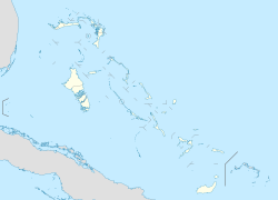
Location of Ocean Cay Airport in the Bahamas
Runways
Direction Length Surface
m ft
09/27 503 1,650 Gravel
17/35 576 1,890 Gravel
Source: Landings.com [1] [2]

Ocean Cay Airport( ICAO : MYBO) is a private use airport located near Ocean Cay, the Bahamas.
ICAO airport code four-letter code designating many airports around the world

The ICAOairport code or location indicator is a four-letter code designating aerodromes around the world. These codes, as defined by the International Civil Aviation Organization and published in ICAO Document 7910: Location Indicators, are used by air traffic control and airline operations such as flight planning.

Airport location where aircraft take off and land

An airport is an aerodrome with extended facilities, mostly for commercial air transport. Airports often have facilities to store and maintain aircraft, and a control tower. An airport consists of a landing area, which comprises an aerially accessible open space including at least one operationally active surface such as a runway for a plane to take off or a helipad, and often includes adjacent utility buildings such as control towers, hangars and terminals. Larger airports may have airport aprons, taxiway bridges, air traffic control centres, passenger facilities such as restaurants and lounges, and emergency services. In some countries, the US in particular, they also typically have one or more fixed-base operators, serving general aviation.

The Bahamas country in North America

The Bahamas, known officially as the Commonwealth of The Bahamas, is a country within the Lucayan Archipelago. The archipelagic state consists of more than 700 islands, cays, and islets in the Atlantic Ocean, and is located north of Cuba and Hispaniola, northwest of the Turks and Caicos Islands, southeast of the U.S. state of Florida, and east of the Florida Keys. The capital is Nassau on the island of New Providence. The designation of "the Bahamas" can refer either to the country or to the larger island chain that it shares with the Turks and Caicos Islands. The Royal Bahamas Defence Force describes the Bahamas territory as encompassing 470,000 km2 (180,000 sq mi) of ocean space.

Contents

See also

Related Research Articles

Castaway Cay private island in the Bahamas

Castaway Cay is a private island in the Bahamas which serves as an exclusive port for the Disney Cruise Line ships. It is located near Great Abaco Island and was formerly known as Gorda Cay. In 1997, The Walt Disney Company purchased a 99-year land lease for the cay from the Bahamian government, set to expire in 2096, giving the company substantial control over the island.

Mores Island Airport airport in the Bahamas

Mores Island Airport is a public use airport located near Moore's Island, the Bahamas.

Scotland Cay Airport airport in Bahamas

Scotland Cay Airport is a private use airport located near Scotland Cay, the Bahamas.

Walkers Cay Airport airport in Bahamas

Walker's Cay Airport is a public use airport located near Walker's Cay, the Bahamas.

Big Whale Cay Airport airport in Bahamas

Big Whale Cay Airport is a public use airport located near Big Whale Cay, the Bahamas.

Lt. Whale Cay Airport airport in Bahamas

Little Whale Cay Berry Islands Airport is a public use airport located on Little Whale Cay, the Bahamas.

Cat Cays Airport airport in Bahamas

Cat Cay Airport is a private airport located on North Cat Cay, the Bahamas. The airport is for the exclusive use of the Cat Cay Yacht Club and requires permission to land. It has the 21st shortest runway in the world, and the 2nd shortest for an ICAO named airport.

Hawks Nest Airport airport in Bahamas

Hawk's Nest Creek Airport is a public use airport located near Hawk's Nest Creek, The Bahamas.

Cay Sal Airport airport in Cay Sal Bank, Bahamas

Cay Sal Airport was an airport located on Cay Sal, the Bahamas. The airstrip which was built there during WWII is now abandoned according to aerial imagery.

Cape Eleuthera Airport former airport in the Bahamas

Cape Eleuthera Airport was a public use airport located 3 nm east-southeast of Cape Eleuthera, The Bahamas. The airport is closed, and the runway is not usable.

Black Point Airport airport in Bahamas

Black Point Airport is a public use airport located near Black Point, the Bahamas.

Farmers Cay Airport airport in Bahamas

Farmer's Cay Airport is a private use airport located near Farmer's Cay, the Bahamas.

Lee Stocking Airport airport in Bahamas

Lee Stocking Airport is a public use airport located near Lee Stocking, the Bahamas.

Rudder Cut Cay Airport airport in Bahamas

Rudder Cut Cay Airport is a public use airport located near Rudder Cut Cay, the Bahamas.

Sampson Cay Airport airport in the Bahamas

Big Sampson Cay Airport is a private use airport located near Big Sampson Cay, the Bahamas.

Fowl Cay Airport airport in Bahamas

Fowl Cay Airport is a public use airport located near Fowl Cay, the Bahamas.

Leaf Cay Airport airport in Bahamas

Leaf Cay Airport is a private use airport located near Leaf Cay, the Bahamas.

Deep Water Cay Airport airport in Bahamas

Deep Water Cay Airport is a private use airport located in Deep Water Cay, the Bahamas.

Andros Central Airport former airport in the Bahamas

Twin Lakes Airport was a public use airport located 15 nm north of Andros Central, the Bahamas. The airport is closed.

References

  1. Airport record for Ocean Cay Airport at Landings.com. Retrieved 2013-08-08
  2. Google (2013-08-08). "location of Ocean Cay Airport" (Map). Google Maps . Google. Retrieved 2013-08-08.