
State Route 26 is a 67-mile-long (108 km) north–south route in south eastern Ohio spanning from SR 7 in Marietta to SR 148 between Jerusalem and Bethesda. SR 26 also passes through Graysville and Woodsfield. Where the state route designation ends in Wayne Township, the road continues north as Belmont County Road 26 where it connects to the Barkcamp State Park and the National Road. Much of the route parallels the Little Muskingum River and travels through the heart of Wayne National Forest's Marietta Unit.

State Route 220 is an east–west state highway in the south central portion of the U.S. state of Ohio. Its western terminus is at SR 772 about 8.25 miles (13.28 km) west of Waverly, and its eastern terminus is at the SR 32/SR 124 concurrency 3 miles (4.8 km) east of Piketon. The entire route is in Pike County.

State Route 231 (SR 231) is a 35.77-mile (57.57 km) long north–south state highway in the northwestern quadrant of the U.S. state of Ohio. SR 231 has its southern terminus at a CSX railroad crossing in the village of Morral. Its northern terminus is in downtown Tiffin at a signalized intersection with SR 18 and SR 101, following a 0.35 miles (0.56 km) long concurrency with SR 100, which continues north as a solo route north of this point.

State Route 99 (SR 99) is a north–south state highway in the north-central portion of the U.S. state of Ohio. The highway's southern terminus is in the southern end of Willard at a T-intersection with U.S. Route 224 (US 224). Its northern terminus is at its junction with SR 4 about 6 miles (9.7 km) southwest of the city limits of Sandusky.
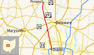
State Route 257 is a 26.19-mile (42.15 km) north - south state highway in the central portion of the U.S. state of Ohio. The highway's southern terminus is in the northwestern Columbus suburb of Dublin at a roundabout intersection with U.S. Route 33 and SR 161. This mainly two-lane highway follows the eastern side of the Scioto River from Dublin to its junction with US 42. After crossing over the river with the U.S. highway, SR 257 parallels the river's western bank. SR 257 has its northern terminus at a T-intersection with SR 47 on the western village limits of Prospect. SR 257 was created in 1926, and extended in 1935 and 1937.
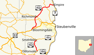
State Route 152 is the designation for two segments of a state highway in Jefferson County, Ohio. The southern segment, which is 6.18 miles (9.95 km) long, runs from SR 150 in Dillonvale to SR 151 in Smithfield. The northern segment, which is 20.20 miles (32.51 km) long, runs from an interchange with U.S. Route 22 (US 22) in Bloomingdale to SR 7 in Empire.

State Route 762 is an east–west state highway in central Ohio, a U.S. state. The highway has its western terminus at a signalized intersection with the concurrency of U.S. Route 62 and SR 3 just 0.25 miles (0.40 km) south of the village limits of Harrisburg. SR 762's eastern terminus is at an intersection of Pickaway County Route 385 near the Rickenbacker International Airport.

State Route 202 (SR 202) is a 20-mile (32 km) north–south state highway in the western part of the U.S. state of Ohio. The highway runs from its southern terminus at an intersection with SR 201 in Dayton to its northern terminus at a T-intersection with SR 55 in the eastern end of Troy.

State Route 188 (SR 188) is a 39.04-mile-long (62.83 km) east–west state highway located in the central part of the U.S. state of Ohio. SR 188's western terminus is in Circleville at a signalized intersection where it meets the concurrency of U.S. Route 22 (US 22) and SR 56. Its eastern terminus is at a signalized intersection with SR 204 in the central business district of the village of Thornville.

State Route 143 is a north–south state highway in the southern portion of the U.S. state of Ohio. It is also home to the famous 143 yard sale, a 20 mile long annual event where anyone on the route is open to host a yard sale. The southern terminus of SR 143 is at a T-intersection with the concurrency of SR 7 and SR 124 approximately one mile (1.6 km) west of the village of Pomeroy. Its northern terminus is at a T-intersection with U.S. Route 50 (US 50) nearly 2.75 miles (4.43 km) southwest of Albany.

State Route 215 is an east–west state highway in the southeastern portion of the U.S. state of Ohio. The western terminus of SR 215 is at a T-intersection with SR 821 just one-half mile (0.80 km) southeast of the village of Belle Valley and SR 821's junction with Interstate 77 (I-77). Its eastern terminus is at another T-intersection, this time with SR 285 just outside the village of Sarahsville.

State Route 175 (SR 175) is a 15.70-mile (25.27 km) long north–south state highway in the northeastern part of the U.S. state of Ohio. The southern terminus of SR 175 is at a signalized intersection with SR 43 in Solon. Its northern terminus is at a signalized intersection with SR 283 in Euclid.
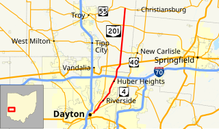
State Route 201 (SR 201) is a 21.69-mile (34.91 km) long north–south state highway in the western portion of the U.S. state of Ohio. The southern terminus of SR 201 is at an interchange with the SR 4 freeway in Dayton. Its northern terminus is at a T-intersection with SR 55 approximately 3.25 miles (5.23 km) east of Casstown.

State Route 362 is a 4.56-mile (7.34 km) north–south state highway in the western part of the U.S. state of Ohio. It serves to connect Lake Loramie State Park with SR 66. Its southern terminus is in Fort Loramie at the intersection of North Main Street (SR 66) and Elm Street. near the northern edge of Fort Loramie. SR 362 then runs about 1.1 miles (1.8 km) east, then turns north at its intersection with Fort Loramie–Swanders Road. SR 362 then runs northerly along the western edge of Lake Loramie and Lake Loramie State Park before turning northwesterly then westerly and enters Minster and reaches its northern terminus at the intersection of South Main Street (SR 66) and First Street.

State Route 276 is a 6.46-mile (10.40 km) long state highway located entirely in Clermont County, Ohio. The route runs from an intersection with West Main Street and 5th Street in Williamsburg to US 50 and SR 132 in Owensville.
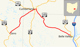
State Route 340 is a 13.2-mile-long (21.2 km) state highway in eastern Ohio. The route runs from its western terminus at SR 284 in the Meigs Township community of Zeno to its eastern terminus at SR 821 in the northwestern corner of Belle Valley.
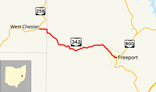
State Route 342 is a 5.27-mile-long (8.48 km) state highway in eastern Ohio. The short route connects SR 258 in the Perry Township community of West Chester to SR 800 in the village of Freeport.

State Route 361 is a 4.67-mile-long (7.52 km) long state highway entirely located within Pickaway Township, Pickaway County, Ohio. The route connects US 23 with SR 159 just north of Kingston.
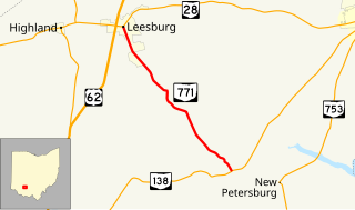
State Route 771 is a 7.11-mile-long (11.44 km) state highway located entirely in Highland County, Ohio. The north–south route connects SR 138 in Paint Township and SR 28 in Leesburg.

State Route 674 is a state highway located southeast of Columbus, Ohio. Most of the route straddles a county line; about 11 miles (18 km) of the southern part of route is on the Pickaway–Fairfield County line while the next 1.4 miles (2.3 km) is on the Fairfield-Franklin County line. The route's southern terminus is at US 22 just north of Stoutsville while the northern terminus is at an interchange with US 33 in the city of Canal Winchester.

