Related Research Articles

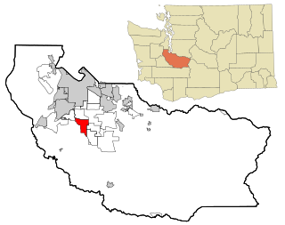
Pierce County is a county in the U.S. state of Washington. As of the 2020 census, the population was 921,130, up from 795,225 in 2010, making it the second-most populous county in Washington, behind King County, and the 60th-most populous in the United States. The county seat and largest city is Tacoma. Formed out of Thurston County on December 22, 1852, by the legislature of Oregon Territory, it was named for U.S. President Franklin Pierce. Pierce County is in the Seattle metropolitan area.

Cross County is a rural Northeast Arkansas county in the Arkansas Delta. Created as Arkansas's 53rd county on November 15, 1862, Cross County contains four incorporated municipalities, including Wynne, the county seat and most populous city. It is named for Confederate Colonel David C. Cross, a political leader in the area.

Eatonville is a town in Orange County, Florida, United States, six miles north of Orlando. It is part of Greater Orlando. Incorporated on August 15, 1887, it was one of the first self-governing all-black municipalities in the United States. The Eatonville Historic District and Moseley House Museum are in Eatonville. Author Zora Neale Hurston grew up in Eatonville and the area features in many of her stories.

Boardman Township is one of the fourteen townships of Mahoning County, Ohio, United States. The population was 40,213 at the 2020 census. A suburb directly south of Youngstown, it is the second largest municipality in the Youngstown–Warren metropolitan area and is a major retail hub for the region.
DuPont is a city in Pierce County, Washington, United States. The population was 10,151 at the 2020 census. Originally a company town, the city is named after the DuPont chemical company which operated an explosives manufacturing plant in the area from 1909 to 1975.

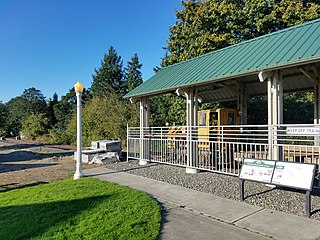
Eatonville is a town in Pierce County, Washington, United States. It is 32 mi (51 km) south of Tacoma. The population was 2,845 at the 2020 census. The town motto is "Better Together".

Elbe is a census-designated place (CDP) in Pierce County, Washington, United States. The population was 29 at the 2010 census.
Spanaway is a census-designated place (CDP) in Pierce County, Washington, United States. The population was 35,476 at the 2020 census, up from 27,227 in 2010. Spanaway is an unincorporated area near Tacoma, and is often identified together with the more urban, less wealthy Parkland.

The Yakama are a Native American tribe with nearly 10,851 members, based primarily in eastern Washington state.

The Colville Indian Reservation is an Indian reservation in the northwest United States, in north central Washington, inhabited and managed by the Confederated Tribes of the Colville Reservation, which is federally recognized.

Fort Nisqually was an important fur trading and farming post of the Hudson's Bay Company in the Puget Sound area, part of the Hudson's Bay Company's Columbia Department. It was located in what is now DuPont, Washington. Today it is a living history museum located in Tacoma, Washington, USA, within the boundaries of Point Defiance Park. The Fort Nisqually Granary, moved along with the Factor's House from the original site of the second fort to this park, is a U.S. National Historic Landmark. Built in 1843, the granary is the oldest building in Washington state and one of the only surviving examples of a Hudson's Bay Company "post-and-plank" structure. The Factor's House and the granary are the only surviving Hudson's Bay Company buildings in the United States.
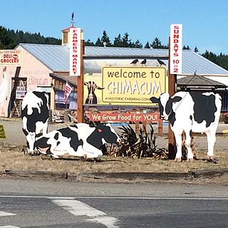
Chimacum is an unincorporated community in Jefferson County, Washington, United States, located in the center of the primary agricultural area of the eastern Olympic Peninsula. It was named after the Chimakum group of Indigenous Americans that lived there until the late 19th century but are now extinct as a distinct cultural group. Chimacum Creek is named after the Chimakum, a Native American people known to themselves as Aqokúlo, who lived on the northeastern portion of the Olympic Peninsula through the mid-19th century and whose economy, culture and religion were based on salmon fishing. Their primary settlements were on Port Townsend Bay, on the Quimper Peninsula, and Port Ludlow Bay to the south. According to tradition, the Chimakum were a remnant of a Quileute band who had been carried away in their canoes by a great flood through a passageway in the Olympic Mountains and deposited on the other side of the peninsula. In 1855 the Twana and Chimakum, along with the Klallam, signed the Point No Point Treaty, which established a reservation at the mouth of the Skokomish River near the southern end of Hood Canal. One of the Chimakum signatories of the treaty was Chief Kulkakhan, also known as General Pierce. After this, most Chimakum people merged into the S’Klallam and Skokomish tribes, where their descendants still live today.

Mineral is an unincorporated community and census-designated place (CDP) in Lewis County, Washington, on State Route 7 near the Pierce/Lewis county line. Mineral originally began as a logging camp and mining town. Prospectors searching the area for gold instead found coal and arsenic. By the early 1920s, the mines closed, and with a devastating fire to the town's largest sawmill, Mineral began to turn to tourism as its main industry, primarily through recreational fishing on Mineral Lake.
The Treaty of Medicine Creek was an 1854 treaty between the United States, and nine tribes and bands of Indians, occupying the lands lying around the head of Puget Sound, Washington, and the adjacent inlets. The tribes listed on the Treaty of Medicine Creek are Nisqually, Puyallup, Steilacoom, Squawskin, S'Homamish, Stehchass, T'Peeksin, Squi-aitl, and Sa-heh-wamish. The treaty was signed on December 26, 1854, by Isaac I. Stevens, governor and superintendent of Indian Affairs of the territory at the time of the signing, along with the chiefs, head-men and delegates of the stated tribes. For the purpose of the treaty, these representatives who signed the treaty were stated to have been, "regarded as one nation, on behalf of said tribes and bands, and duly authorized by them."

The history of Olympia, Washington, includes long-term habitation by Native Americans, charting by a famous English explorer, settlement of the town in the 1840s, the controversial siting of a state college in the 1960s and the ongoing development of arts and culture from a variety of influences.

Robert Hungerford Preparatory High School was a segregated high school for African Americans in Eatonville, Florida.
The Mashel River is a river in Pierce County, in the U.S. state of Washington. It is a tributary of the Nisqually River, which it enters about 3.6 miles (5.8 km) southwest of Eatonville, at Nisqually river mile 39.6.

Kingston is the only city in, and the county seat of, Ulster County, New York, United States. It is 91 miles (146 km) north of New York City and 59 miles (95 km) south of Albany. The city's metropolitan area is grouped with the New York metropolitan area around Manhattan by the United States Census Bureau. The population was 24,069 at the 2020 United States Census.

Alder Lake is a 7 mi (11 km) long reservoir on the Nisqually River in Eatonville, Washington in the U.S. state of Washington, which was created by the construction of Alder Dam by Tacoma Power in September 1944. At the very eastern end of the lake is the town of Elbe, Washington.
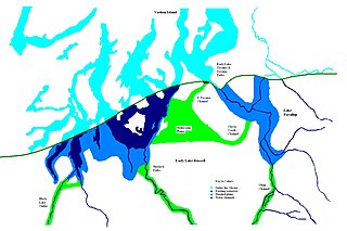
Lake Puyallup developed along the south edge of the Puget Sound Glacier. The glacier was in retreat northward after having reached its most southerly point. Drainage off the north face of Mount Rainier and the melting ice of the glacier was trapped in the valley of the Puyallup River. As the glacier moved north, the lake grew until it reached its largest capacity with the glacier at the glacial front across the Puyallup valley just south of Commencement Bay at Tacoma and northern bend of the White River at Auburn. When the ice retreated further north, it was reduced in depth and volume and takes on the name of Lake Tacoma.
References
- ↑ "US Board on Geographic Names". United States Geological Survey. October 25, 2007. Retrieved January 31, 2008.
- ↑ "The Ohop Valley and the Surrounding Area". Washington Secretary of State . Retrieved December 9, 2019.
- ↑ "Ohop Creek". Nisqually Land Trust. Retrieved December 9, 2019.
- ↑ Shirley, Hannah (June 26, 2016). "Historic Ohop Valley farm getting new life as school campus". The News Tribune. Retrieved December 9, 2019.
| Authority control: National |
|---|