
Dutch New Guinea or Netherlands New Guinea was the western half of the island of New Guinea that was a part of the Dutch East Indies until 1949, later an overseas territory of the Kingdom of the Netherlands from 1949 to 1962. It contained what are now Indonesia's six easternmost provinces, Central Papua, Highland Papua, Papua, South Papua, Southwest Papua, and West Papua, which were administered as a single province prior to 2003 under the name Irian Jaya, and now comprise the Papua region of the country.

The First Australian Army was a field army of the Australian Army, during World War II. The formation's headquarters was raised in April 1942 from the existing 1st Australian Corps headquarters, assuming command of all Allied troops in Queensland. Initially, the formation was assigned a defensive role in anticipation of a possible Japanese invasion; however, this threat subsided and eventually the army was deployed to Lae, in New Guinea, in late 1944, where it co-ordinated Australian offensives around Aitape, in New Guinea, on New Britain and Bougainville, and around Madang. The formation was disbanded in February 1946, when it was redesignated as the 8th Military District.

Western New Guinea, also known as Papua, Indonesian New Guinea, and Indonesian Papua, is the western half of the island of New Guinea, formerly Dutch and granted to Indonesia in 1962. Given the island is alternatively named Papua, the region is also called West Papua.

No. 120 Squadron was a joint Dutch and Australian squadron of World War II. The squadron was first formed in December 1943 as part of the Royal Australian Air Force (RAAF), and saw combat in and around New Guinea during 1944 and 1945 equipped with P-40 Kittyhawk fighters. Following the war, No. 120 Squadron was transferred to the Netherlands East Indies Air Force in 1946 and participated in the Indonesian National Revolution.

The Catholic Church in Indonesia is part of the worldwide Catholic Church, under the spiritual leadership of the pope in Rome. Catholicism is one of the six approved religions in Indonesia, the others being Islam, Protestantism, Hinduism, Buddhism, and Confucianism. According to official figures, Catholics made up 3.12 percent of the population in 2018. The number of Catholics is, therefore, more than 8.3 million. Indonesia is primarily Muslim, but Catholicism is the dominant faith in certain areas of the country.
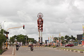
Merauke is a large town (kelurahan) and an administrative district (distrik) in Merauke Regency of South Papua Province, Indonesia. It is also the administrative centre of Merauke Regency, and is considered to be the easternmost city in Indonesia, although it currently lacks city status. The town was originally called Ermasoe. It is next to the Maro River where the Port of Merauke is located. Merauke District covers a land area of 500.41 km2, and had a population of 87,634 at the 2010 Census. which at the 2020 Census had increased to 102,351; the official estimate as at mid 2023 was 110,541.

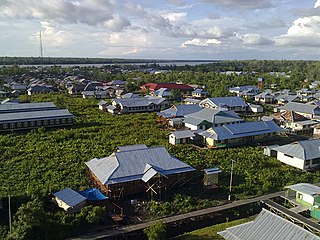
Sorong is the largest city and the capital of the Indonesian province of Southwest Papua. The city is located on the western tip of the island of New Guinea with its only land borders being with Sorong Regency. It is the gateway to Indonesia's Raja Ampat Islands, species rich coral reef islands in an area considered the heart of the world's coral reef biodiversity. It also is the logistics hub for Indonesia's thriving eastern oil and gas frontier. Sorong experienced rapid growth during the decade from 2010, and further growth is anticipated as Sorong becomes linked by road to other frontier towns in Papua's Bird's Head Peninsula. The official estimate of population as at mid 2023 was 294,978 - comprising 154,543 males and 140,435 females. The suburban area of Sorong city contains tropical rainforest and mangrove forest that has increasingly become popular as ecotourism attractions especially for birdwatching or wildlife watching.

Christianity is Indonesia's second-largest religion, after Islam. Indonesia also has the second-largest Christian population in Southeast Asia after the Philippines, the largest Protestant population in Southeast Asia, and the third-largest Christian population in Asia after the Philippines and China. Indonesia also has the second-largest Christian population in the Muslim world, after Nigeria, followed by Egypt. Indonesia's 29.4 million Christians constituted 10.47% of the country's population in 2023, with 7.41% Protestant and 3.06% Catholic. Some provinces in Indonesia are majority Christian. In Indonesia, the word Kristen refers to Protestantism, while Catholicism is referred to as Katolik. In the 21st century the rate of growth and spread of Christianity has increased, especially among the Chinese minority.

Protestantism is one of the six approved religions in Indonesia, the others being Islam, Roman Catholicism, Hinduism, Buddhism, and Confucianism. It constitutes the bulk of Christianity in Indonesia, which is the second largest religion in the country after Islam.

Merauke Force was an Australian-led military force of World War II which was responsible for defending Merauke in Dutch New Guinea from Japanese attack amidst the Pacific War. The force was established in late 1942 and was disbanded at the end of the war, having never seen combat. The Japanese attack did not eventuate and from mid-1944 the force was progressively drawn down and its assigned units redeployed to Australia or elsewhere in the Pacific. At its height, Merauke Force included troops from Australia, the Netherlands East Indies and the United States, as well as several squadrons of aircraft, including a joint Australian-Dutch fighter unit.
The Roman Catholic Diocese of Amboina is a diocese located in the city of Amboina in the ecclesiastical province of Makassar in Indonesia.

Albertus Soegijapranata, SJ, better known by his birth name Soegija, was a Jesuit priest who became the Apostolic Vicar of Semarang and later its archbishop. He was the first native Indonesian bishop and known for his pro-nationalistic stance, often expressed as "100% Catholic 100% Indonesian".
Mgr. Adrianus Djajasepoetra, SJ, was an Indonesian Roman Catholic prelate who served as the Vicar Apostolic of Jakarta and later its Archbishop (1953–1970). Before being a Vicar Apostolic, Mgr. Adrianus was a Rector of St. Ignatius College, Yogyakarta and the 4th Rector of Major Seminary, Kentungan, Yogyakarta (1948-1949).
Agats is a town in Asmat Regency, South Papua, Indonesia. An elevated settlement on a tidal plain, a Dutch outpost was set up in Agats in 1938 and the town became notable for the cultural practices of the Asmat people. Following the formation of Asmat Regency in 2002, the town became its administrative seat.

Operation Oaktree was a Dutch military operation in Dutch New Guinea during World War II. Under the command of Captain Jean Victor de Bruijn, some 40 soldiers operated in the highland region of Western New Guinea for more than two years between December 1942 and July 1944, handled by the Netherlands East Indies Forces Intelligence Service, with Australian assistance.

The Free Dutch Forces refers to the Dutch military formations of the Dutch government-in-exile and its colonies that were formed to fight alongside the Western Allies against Nazi Germany and its allies during World War II following the Dutch surrender in May 1940.
Bupul is an inland village in Merauke Regency, South Papua, Indonesia.
Kepi is a town in Mappi Regency, South Papua, Indonesia. Following the formation of Mappi Regency in 2002, the town became its administrative seat.
Isyaman is an inland village in Mappi Regency, South Papua, Indonesia.
Sungai Selan is a district (kecamatan) of Central Bangka Regency, in the Bangka-Belitung province of Indonesia.


