| Okamatapati | |
|---|---|
| Settlement | |
 Okamatapati Location in Namibia | |
| Coordinates: 20°24′S18°13′E / 20.400°S 18.217°E Coordinates: 20°24′S18°13′E / 20.400°S 18.217°E | |
| Country | |
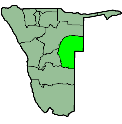
| Region | Otjozondjupa Region |
| Constituency | Okakarara Constituency |
| Population (2016) | |
| • Total | 1,900 |
| Time zone | South African Standard Time (UTC+1) |
Okamatapati is a settlement in the Otjozondjupa Region of Namibia, situated 100 kilometres (62 mi) south of Grootfontein and 127 kilometres (79 mi) north of Otjinene. [1] The name Okamatapati is derived from Omutapati, the Otjiherero name for the Mouse-eared combretum, a shrub that is common in the area. [2]
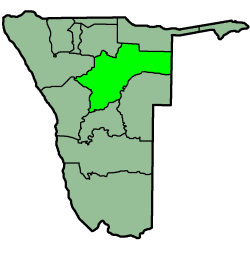
Otjozondjupa region is one of the fourteen regions of Namibia, whose capital is Otjiwarongo. An outstanding landmark within this region is the Waterberg Plateau Park. Administration offices are based in Otjiwarongo which is the largest town in the region.

Namibia, officially the Republic of Namibia, is a country in southern Africa. Its western border is the Atlantic Ocean; it shares land borders with Zambia and Angola to the north, Botswana to the east and South Africa to the south and east. Although it does not border Zimbabwe, less than 200 metres of the Zambezi River separates the two countries. Namibia gained independence from South Africa on 21 March 1990, following the Namibian War of Independence. Its capital and largest city is Windhoek, and it is a member state of the United Nations (UN), the Southern African Development Community (SADC), the African Union (AU), and the Commonwealth of Nations.

Grootfontein is a city of 23,793 inhabitants in the Otjozondjupa Region of central Namibia. It is one of the three towns in the Otavi Triangle, situated on the B8 national road that leads from Otavi to the Caprivi Strip. Grootfontein receives an annual average rainfall of 557 millimetres (21.9 in), although in the 2010/2011 rainy season 956 millimetres (37.6 in) were measured.
Herero people were resettled to this area, then known as Hereroland, in the 1960s. The Odendaal Plan declared several bantustans, one for each tribe, and forced Blacks to vacate all other areas of then-South-West Africa. Okamatapati was situated at the western edge of the Herero area. An affluent community developed who soon elected their own tribal chiefs. [3]
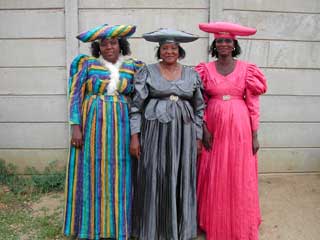
The Herero, also known as Ovaherero, are an ethnic group inhabiting parts of Southern Africa. The majority reside in Namibia, with the remainder found in Botswana and Angola. There were an estimated 250,000 Herero people in Namibia in 2013. They speak Otjiherero, a Bantu language.

Hereroland was a bantustan in South West Africa, intended by the apartheid government to be a self-governing homeland for the Herero people. It was set up in 1968 and self-government was granted two years later.
A Bantustan was a territory set aside for black inhabitants of South Africa and South West Africa, as part of the policy of apartheid. Ten Bantustans were established in South Africa, and ten in neighbouring South West Africa, for the purpose of concentrating the members of designated ethnic groups, thus making each of those territories ethnically homogeneous as the basis for creating "autonomous" nation states for South Africa's different black ethnic groups.
The Okamatapati Farmers Association was founded in 1983. It ran the first Okamatapati Show, an agricultural show for cattle farmers, in 1986. The show has been run for the 28th time in 2016 but is no longer conducted in Okamatapati. In 2012 it moved to Windhoek and became part of the Windhoek Show. Except a one-time stint at the Grootfontein Show in 2014 it is now held annually in Windhoek. [4]

The Windhoek Industrial and Agricultural Show is an annual trade fair in Windhoek, the capital of Namibia. It combines an agricultural exhibition, several industrial and retail offerings, and a range of entertainment facilities. The Windhoek Show was first held in 1899 and is since 1966 conducted annually. Held during the first week of October, the Windhoek Show is the biggest industrial and agricultural exhibition in Namibia. It attracts close to 100,000 visitors per year.
Today the area around Okamatapati is a conservancy of 3,096 square kilometres (1,195 sq mi) that has been established in 2005. In 2016 [update] it had a population of 1,899 people. The conservancy consists of flat, sandy thornveld savannah and has an average annual rainfall of 350–400 millimetres (14–16 in). The main economic activity is cattle farming, particularly weaner production, which is supported by the occurrence of Terminalia sericea , a deciduous tree that the animals feed on during the dry season. Devil's claw is also harvested here. [2]

A calf is the young of domestic cattle. Calves are reared to become adult cattle, or are slaughtered for their meat, called veal, and for their calfskin.
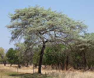
Terminalia sericea is a species of deciduous tree of the genus Terminalia that is native to southern Africa. Its common names include clusterleaf, silver cluster-leaf or silver terminalia in English, vaalboom in Afrikaans and mususu in Venda.
In the fields of horticulture and botany, the term deciduous (/dɪˈsɪdʒuəs/) means "falling off at maturity" and "tending to fall off", in reference to trees and shrubs that seasonally shed leaves, usually in the autumn; to the shedding of petals, after flowering; and to the shedding of ripe fruit.
The road from Otjinene to Grootfontein, an extension of the Trans-Kalahari Highway which passes Okamatapati, is currently [update] being tarred. The work is expected to be completed in 2017. [1]