
State Highway 20 is a highway in northeastern Oklahoma. Its eastern terminus is at the corner of Oklahoma, Arkansas, and Missouri near Southwest City, Missouri; its western terminus is at State Highway 18 near Ralston. The highway runs a total length of 142.7 miles (229.7 km). It has no lettered spur routes.

State Highway 2, abbreviated SH-2 or OK-2, is a designation for two distinct highways maintained by the U.S. state of Oklahoma. Though they were once connected, the middle section of highway was concurrent with three different U.S. highways, so the middle section was decommissioned for reasons of redundancy.

State Highway 251A, also known as SH-251A or OK-251A, is a highway maintained by the U.S. state of Oklahoma. The highway has a length of 5.37 miles (8.64 km) in Wagoner County and 0.69 miles (1.11 km) in Cherokee County, for a total length of 6.06 miles (9.75 km). The highway runs from State Highway 16 in Okay, Oklahoma to State Highway 80 north of Ft. Gibson. It runs across the dam of Fort Gibson Lake. The highway was once part of SH-16.

State Highway 137 (SH-137) is a 6.31-mile (10.15 km) highway in Ottawa County, Oklahoma. It is a two-lane highway beginning at State Highway 10 east of Miami and ends at U.S. Highway 60 in Twin Bridges State Park on the north side of the Grand Lake o' the Cherokees. It has no lettered spur routes.
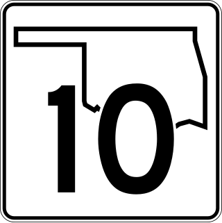
State Highway 10 is a state highway in northeastern Oklahoma. It makes a 233.1 miles (375.1 km) crescent through the northeast corner of the state, running from SH-99 in Osage County to Interstate 40 (I-40) near Gore. It has two lettered spur routes.

State Highway 53 is an 86.6-mile (139.4 km) highway in southern Oklahoma. It connects Walters in Cotton County to Gene Autry in Carter County. It has one lettered spur route, SH-53A, a spur route to Gene Autry.

State Highway 125 is a state highway in northeastern Oklahoma that is 25.7 miles (41.4 km) long. It begins in the south at Grand Lake O' the Cherokees, ending in Miami at US-69/SH-10. It has no lettered spur routes.

State Highway 164 is a state highway in north-central Oklahoma. It runs from SH-74 in Covington to U.S. Route 77 (US-77) west of Perry. SH-164 is 12.64 miles (20.34 km) long. It has no lettered spur routes.

State Highway 71 is a state highway in eastern Oklahoma. It runs from State Highway 31 in Quinton north to intersect State Highway 9 near Enterprise. It then continues north to Lake Eufaula Dam, and then turns east to end at State Highway 2. It has no lettered spur routes.

State Highway 151 runs 2.30 miles (3.70 km) across Keystone Dam in northeastern Oklahoma. Its entire length is within Tulsa County. The route has no lettered spur routes.

State Highway 149 is a state highway in Oklahoma. It runs 8.19 miles (13.18 km) in Harper County, from US-283 in Laverne to SH-46, seven miles (11 km) north of May.

State Highway 147 is a state highway in Oklahoma. It runs 13.58 miles (21.85 km) in Choctaw and Pushmataha counties. Highway 147 begins at US-70, just east of Sawyer. From there it runs north, up the east side of Hugo Lake. There is a one-mile (1.6 km) dogleg to the east just south of the community of Spencerville, and another short dogleg east at the Choctaw–Pushmataha county line. SH-147 terminates at SH-3 in Oleta.

State Highway 54 is a state highway in western Oklahoma. Running north–south, it exists in two parts, which lie at approximately the same longitude. The southern section's length is 9.96 miles (16.03 km), while the northern section runs for 85.5 miles (137.6 km), for a combined length of 95.5 miles (153.7 km). The northern section has two lettered spur routes.

State Highway 127 (SH-127) is a state highway in Delaware County, Oklahoma. It runs from US-59/SH-10/SH-20 in Jay, through the community of Zena, and ends at US-59/SH-10 north of Jay. Its total length is 13.08 miles (21.05 km) It has no lettered spur routes.

State Highway 115 is a 57.2 mile (92 km) long state highway in western Oklahoma, passing through Comanche, Kiowa, and Washita Counties as well as the Wichita Mountains Wildlife Refuge. The highway has no lettered spur routes.

U.S. Route 69 is a major north-south U.S. Highway in the U.S. state of Oklahoma. It extends the corridor formed by U.S. Route 75 in Texas, from Dallas northeast via McAlester and Muskogee to the Will Rogers Turnpike near Vinita. From Vinita to the Kansas state line, US-69 generally parallels the turnpike along old U.S. Highway 66.

State Highway 116 is a state highway in Delaware County, Oklahoma, United States. It runs for 11.55 miles (18.59 km) and has no lettered spur routes.

U.S. Highway 59 (US-59) heads along the eastern portion of the state of Oklahoma. US-59's 216.47-mile (348.37 km) route through Oklahoma takes it through the mountainous terrain of the eastern Oklahoma Ouachitas and Ozarks. US-59 serves several lakes and towns through Oklahoma's Green Country, including Grand Lake, a major recreation center. The route enters the state from Arkansas near Fogel, Arkansas, and ends at the Kansas state line south of Chetopa, Kansas.

U.S. Route 169 is a U.S. highway that begins in Tulsa southeast of Downtown. The highway runs north into Kansas.

U.S. Route 60 (US-60) is a transcontinental U.S. highway extending from near Brenda, Arizona to Virginia Beach, Virginia on the Atlantic Ocean. Along the way, 352.39 miles (567.12 km) of the route lies within the state of Oklahoma. The highway crosses into the state from Texas west of Arnett and serves many towns and cities in the northern part of the state, including Arnett, Seiling, Fairview, Enid, Ponca City, Pawhuska, Bartlesville, and Vinita. US-60 exits Oklahoma near Seneca, Missouri. In Oklahoma, US-60 has three business routes, serving Tonkawa, Ponca City, and Seneca. The first 60.2 miles (96.9 km) of the route, from the Texas line to Seiling, is also designated as State Highway 51 (SH-51).

