Palakkad is one of the 14 districts in the Indian state of Kerala. It was carved out of the southeastern region of the former Malabar District on 1 January 1957. It is located at the central region of Kerala and is the second largest district in the state after Idukki. The city of Palakkad is the district headquarters. Palakkad is bordered on the northwest by the Malappuram district, on the southwest by the Thrissur district, on the northeast by Nilgiris district, and on the east by Coimbatore district of Tamil Nadu. The district is nicknamed "The granary of Kerala". Palakkad is the gateway to Kerala due to the presence of the Palakkad Gap, in the Western Ghats. The 2,383 m high Anginda peak, which is situated in the border of Palakkad district, Nilgiris district, and Malappuram district, in Silent Valley National Park, is the highest point of elevation in Palakkad district. Palakkad city is about 347 kilometres (216 mi) northeast of the state capital, Thiruvananthapuram.
Eranhipalam is a suburb of Kozhikode City, in the Kozhikode district of the state of Kerala, South India. It is where the Civil Station and the Passport Office are located. A new bridge is being constructed as part of a major facelift to the area. It is located on Mini Bypass Road. Zonal Office of State Bank of Travancore is situated here. Central Government has sanctioned a Flyover from Calicut Beach and ending at Eranhipalam near Jayasree Group Property under Bharathmala scheme. This Flyover will be passing through Panicker Road.
Malampuzha, is a town and suburb of Palakkad city, Kerala, India. It is located about 3.5km from Malampuzha Dam and 6km from city centre.

Muthuthala is a small town, village and gram panchayat. It lies northwest of Pattambi in Palakkad district, of the state of Kerala, India. It is located on the banks of the Bharathapuzha River. The infrastructure of the panchayath is divided into Kodumunda and Muthuthala.Muthuthala, Kodumunda and Karakkuth are important centres. The adjacent villages to Muthuthala are Pallippuram, Koppam and Pattambi. The major institutions are GOHSS Pattambi, GHSS Kodumunda, GLPS Kodumunda AMLP Kodumunda, Aups muthuthala, Aups perumudiyoor, SBI muthuthala etc. Also there are temples such as sree muthassiyar kavu, ayappan kavu, Ganapthi temple muthuthala. Siva temple perumudiyoor, kozhikottii temple etc. The main Islamic symbol of this village is Muhyidheen Juma Masjid located at Muthuthala centre. An Islamic educational institution named as Thanveerul Islam Madrassa is also running near to this. Thes agnostoma somayagam is conducted at perumudiyoor on 2016. Lakhs of people visited there. Major cultivation is paddy here. Banana and rubber plantations are also abundant here.

Palakkad, also known as Palghat, historically known as Palakkattussery, is a city and municipality in the Indian state of Kerala. It is the administrative headquarters of Palakkad District. Palakkad is the most densely populated municipality and the fourth-most densely populated city in the state. It was established before Indian independence under British rule and known by the name Palghat. Palakkad is famous for the ancient Palakkad Fort, which is in the heart of the city and was captured and rebuilt by Hyder Ali in 1766 which later fell into the hands of Zamorin in 1784. The city is about 347 kilometres (216 mi) northeast of the state capital, Thiruvananthapuram.
Pachattiri is a small village located near Tirur in Kerala, India. It lies on the banks of the Tirur River. A temple devoted to Krishna is located here, as is a temple devoted to Shiva.This was a part of the Kingdom of Tanur (Vettattnad) kingdom in medieval times.

Ollur is a major suburban area and an old commercial town in the city of Thrissur of Kerala state, South India. It is about five kilometres (3.1 mi) away from Swaraj Round on old National Highway 47 (India) towards Kochi. From ancient time onwards, Ollur was a major business centre in Thrissur district. Now, this geographical area is part of Thrissur Municipal Corporation. It is situated between Kuriachira and Thalore on the National Highway. However, a specific identity for this geographical region is still there due to the urban setting of this region and its important religious institutions.
Cheriyamundam is a village and Grama Panchayat in Kerala, India. It covers an area of 11.95 km2 and includes 25,760 (1991) inhabitants. It lies near the Tirur River.

Vaniyamkulam is an old town and an important trading hub of Southern Malabar in Kerala state, India, particularly of livestock arriving from the neighbouring state of Tamil Nadu. The name derived from 'Vaniyan', connected with a trading community. It is part of the Palakkad District.
Mankurussi or Mankurissi is a small town near Palakkad in the state of Kerala in southern India.
Pulamanthole is a Panchayath in Malappuram district of Kerala, India. It is situated on the banks of Kunthippuzha. The river separates Malappuram and Palakkad districts, a new bridge has been built across it recently.
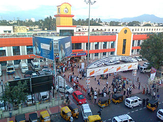
Coimbatore Junction Railway Station, also known as Kovai Junction Railway Station, is a major railway station located in the city of Coimbatore in the state of Tamil Nadu, India. It is one of the busiest railway stations in South India and serves as a gateway to the Nilgiri hills, a popular tourist destination. The station is operated by the Southern Railway zone of Indian Railways and has six platforms. Coimbatore is the third highest revenue generating station in the Southern Railway after Chennai Central and Egmore railway stations and is the station that generates about 45 percent of the revenue of the Salem Railway division. Coimbatore Junction is an important junction connecting major cities such as Chennai, Bangalore, Mumbai, Delhi, and Kolkata. It also serves as a gateway to several popular tourist destinations such as Ooty and Kodaikanal. Although Coimbatore railway station has the suffix Junction in its name, it's not a true junction. No new line starts from or ends at Coimbatore. It's just a passing railway station lies between Podanur Junction and Coimbatore North Junction.
Angadippuram is a census town and major suburb of Perinthalmanna town, in the Malappuram District of Kerala. It was the capital of the powerful medieval kingdom of Valluvanad. Angadippuram is also known for Angadippuram Laterite, a notified geo-heritage monument. Angadippuram is famous for its two temples, the Thirumandhamkunnu Temple and the Tali Mahadeva Temple. Kozhikode - Palakkad National Highway 966 passes through the town and Angadipuram Railway Station is one of the major railway stations on the Nilambur - Shornur Line of Palakkad Division, Southern Railways. It is connected to the major cities Kochi and Thiruvananthapuram by this line.

Mukkam is a major municipality town in Kozhikode, state of Kerala, India. Mukkam is one of the major regional suburb of the Kozhikode district. Mukkam is located about 27 km east of Calicut city on the bank of river Iruvanjippuzha, one of the major tributaries of river Chaliyar. Mukkam is also well knows for its secularistic features. The urban region of Mukkam is spread across Mukkam Municipality and the North Karassery region of Karassery Grama Panchayath. The town begins from North Karassery junction region and runs till Agasthianmuzhi Junction region.

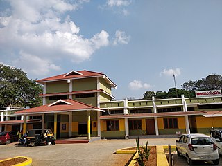
Palakkad Junction is one of the largest railway station in Kerala state, India situated in the city of Palakkad and the second largest railway station in the district. Palakkad Junction is the cleanest railway station in the state of Kerala as per the survey conducted by Indian Railway Catering & Tourism Corporation. It also boasts one of the longest railway platforms in Kerala. Palakkad Junction serves as the major railway hub for the city of Palakkad in Kerala while the secondary hub, Palakkad Town railway station which is situated in the heart.
Perumbadappu is a village located in Ponnani taluk, Malappuram district, Kerala state, India. It is situated 15 kilometers south of Ponnani, bordering Thrissur district. Perumbadappu is also headquarters of one of the 15 Block Panchayats in the district and a police station. Perumbadappu is located south of Veliyankode, in the middle of Malabar Coast.
Karinkallathani is a town in Perinthalmanna taluk of the Malappuram district of the Indian state of Kerala.
Cholakkulam is a village in Malappuram district of Kerala. It is situated in Melattur. The name Cholakkulam came from the Malayalam words 'Chola' (Stream), 'Kulam' (Pond); i.e., 'Place where is pond with stream'. The village is well connected to Perinthalmanna (17 km), Mannarkkad (24 km), Manjeri (23 km) and Karuvarakundu (11 km). The shortest route connecting Kozhikode with Palakkad passes through this village.
Kozhikode district has an extensive network of road, rail and air travel services. Kozhikode city is the epicenter of the district. Vatakara and Thamarassery are other transport hubs.
Vazhempuram is a location in Karakurussi Grama Panchayath in Palakkad district of Kerala.