Old Bavarian Donaumoos

Last updated
Designations
Official name Donauauen & Donaumoos
Designated 26 February 1976
Reference no. 90 [1]

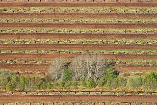
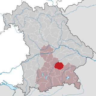
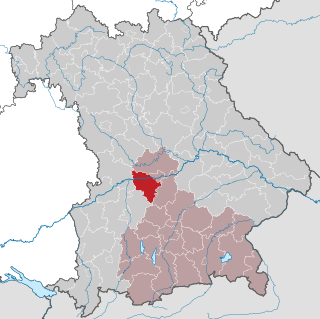
The Old Bavarian Donaumoos (German : Altbayerisches Donaumoos) is an old fen on the southern side of the Danube, southwest of Ingolstadt, Bavaria, in the Neuburg-Schrobenhausen district. The fen, drained from 1790 onwards, has now dropped 3 metres (9.8 ft) in surface level because of the drainage and associated environmental effects. [2] [3] The Donaumoos was once the largest area of fenland in Southern Germany. [4]

German language West Germanic language

German is a West Germanic language that is mainly spoken in Central Europe. It is the most widely spoken and official or co-official language in Germany, Austria, Switzerland, South Tyrol (Italy), the German-speaking Community of Belgium, and Liechtenstein. It is also one of the three official languages of Luxembourg and a co-official language in the Opole Voivodeship in Poland. The languages which are most similar to German are the other members of the West Germanic language branch: Afrikaans, Dutch, English, the Frisian languages, Low German/Low Saxon, Luxembourgish, and Yiddish. There are also strong similarities in vocabulary with Danish, Norwegian and Swedish, although those belong to the North Germanic group. German is the second most widely spoken Germanic language, after English.

Altbayern

Altbayern is the territory and people of the three oldest parts of the Free State of Bavaria, which were earlier known as Kurbayern after the former Electorate of Bavaria.

Fen type of wetland

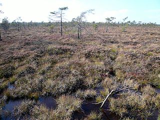
A fen is one of the main types of wetland, the others being grassy marshes, forested swamps, and peaty bogs. Along with bogs, fens are a kind of mire. Fens are minerotrophic peatlands, usually fed by mineral-rich surface water or groundwater. They are characterised by their distinct water chemistry, which is pH neutral or alkaline, with relatively high dissolved mineral levels but few other plant nutrients. They are usually dominated by grasses and sedges, and typically have brown mosses in general including Scorpidium or Drepanocladus. Fens frequently have a high diversity of other plant species including carnivorous plants such as Pinguicula. They may also occur along large lakes and rivers where seasonal changes in water level maintain wet soils with few woody plants. The distribution of individual species of fen plants is often closely connected to water regimes and nutrient concentrations.

Contents

It is one of two former fens named Donaumoos, the other being the Swabian Donaumoos (German : Schwäbisches Donaumoos), also predominantly located in Bavaria, between Ulm and Gundelfingen. Of the Bavarian fens, the Moose, 95 percent have been dried out, a trend the Bavarian government wishes to reverse by re-flooding some of the former fens. [5]

Ulm Place in Baden-Württemberg, Germany

Ulm is a city in the federal German state of Baden-Württemberg, situated on the River Danube. The city, whose population is estimated at almost 120,000 (2015), forms an urban district of its own and is the administrative seat of the Alb-Donau district. Founded around 850, Ulm is rich in history and traditions as a former free imperial city. Today, it is an economic centre due to its varied industries, and it is the seat of the University of Ulm. Internationally, Ulm is primarily known for having the church with the tallest steeple in the world, the Gothic minster, and as the birthplace of Albert Einstein.

Gundelfingen Place in Baden-Württemberg, Germany

Gundelfingen im Breisgau is a municipality directly north of the city Freiburg in Baden-Württemberg in southern Germany.

History

View of the Donaumoos Berg im Gau Donaumoos 2.jpg
View of the Donaumoos

The Donaumoos was formed after the last glacial period, which ended approximately 10,000 years ago, in the wet lowlands on the southern side of the Danube (German : Donau). Over a period of time, peat was formed in the Donaumoos through the incomplete decomposing of plant materials. The peat formed at a rate of one millimetre per annum, to eventually reach a thickness of up to 10 metres in the Donaumoos. [2]

Peat accumulation of partially decayed vegetation

Peat, also known as turf, is an accumulation of partially decayed vegetation or organic matter. It is unique to natural areas called peatlands, bogs, mires, moors, or muskegs. The peatland ecosystem is the most efficient carbon sink on the planet, because peatland plants capture CO2 naturally released from the peat, maintaining an equilibrium. In natural peatlands, the "annual rate of biomass production is greater than the rate of decomposition", but it takes "thousands of years for peatlands to develop the deposits of 1.5 to 2.3 m [4.9 to 7.5 ft], which is the average depth of the boreal [northern] peatlands". Sphagnum moss, also called peat moss, is one of the most common components in peat, although many other plants can contribute. The biological features of Sphagnum mosses act to create a habitat aiding peat formation, a phenomenon termed 'habitat manipulation'. Soils consisting primarily of peat are known as histosols. Peat forms in wetland conditions, where flooding or stagnant water obstructs the flow of oxygen from the atmosphere, slowing the rate of decomposition.

Up until 1790, the 180 square kilometres of the Donaumoos fen were mostly inaccessible. From 1790 onwards, under the initiative of Charles Theodore, Elector of Bavaria, the fen was systematically drained. 473 kilometres of canals were built to drain the Donaumoos and, alongside the straight canals, villages were formed. Living conditions in the Moos were however difficult and new settlers for the region were hard to find. [2]

Charles Theodore, Elector of Bavaria German nobleman and elector

Charles Theodore reigned as Prince-elector and Count Palatine from 1742, as Duke of Jülich and Berg from 1742 and also as prince-elector and Duke of Bavaria from 1777 to his death. He was a member of the House of Palatinate-Sulzbach, a branch of the House of Wittelsbach.

To compensate for the later problem, the Bavarian government relaxed its long-standing policy of not allowing non-Catholics to live in Bavaria. In 1802, it permitted 120 Mennonite families to settle in the Danube fens. The new settlers were given numerous advantages, like subsidies, freedom from military service, tax-and rent-free use of the land for 10 years. Economic difficulties in the mid-1850s however forced the Mennonites to abandon their colony again and eventually emigrate to the United States. [6]

Electorate of Bavaria

The Electorate of Bavaria was an independent hereditary electorate of the Holy Roman Empire from 1623 to 1806, when it was succeeded by the Kingdom of Bavaria.

United States Federal republic in North America

The United States of America (USA), commonly known as the United States or America, is a country comprising 50 states, a federal district, five major self-governing territories, and various possessions. At 3.8 million square miles, the United States is the world's third or fourth largest country by total area and is slightly smaller than the entire continent of Europe's 3.9 million square miles. With a population of over 327 million people, the U.S. is the third most populous country. The capital is Washington, D.C., and the largest city by population is New York City. Forty-eight states and the capital's federal district are contiguous in North America between Canada and Mexico. The State of Alaska is in the northwest corner of North America, bordered by Canada to the east and across the Bering Strait from Russia to the west. The State of Hawaii is an archipelago in the mid-Pacific Ocean. The U.S. territories are scattered about the Pacific Ocean and the Caribbean Sea, stretching across nine official time zones. The extremely diverse geography, climate, and wildlife of the United States make it one of the world's 17 megadiverse countries.

Other Protestants - Lutherans and some reformed - settled in the Donaumoos to stay, however. As a result, in the 19th century there established three Protestant parishes in Karlshuld, Ludwigsmoos and Untermaxfeld, some of the very few existing in rural southern Bavaria before 1945. Apart from non-Catholics, the Bavarian government also recruited convicts to settle in the area. [7]

Protestantism division within Christianity, originating from the Reformation in the 16th century against the Roman Catholic Church, that rejects the Roman Catholic doctrines of papal supremacy and sacraments

Protestantism is the second largest form of Christianity with collectively between 800 million and more than 900 million adherents worldwide or nearly 40% of all Christians. It originated with the 16th century Reformation, a movement against what its followers perceived to be errors in the Roman Catholic Church. Protestants reject the Roman Catholic doctrine of papal supremacy and sacraments, but disagree among themselves regarding the real presence of Christ in the Eucharist. They emphasize the priesthood of all believers, justification by faith alone rather than by good works, and the highest authority of the Bible alone in faith and morals. The "five solae" summarise basic theological differences in opposition to the Roman Catholic Church.

Lutheranism form of Protestantism commonly associated with the teachings of Martin Luther

Lutheranism is a major branch of Western Christianity that identifies with the teaching of Martin Luther, a 16th century German reformer. Luther's efforts to reform the theology and practice of the church launched the Protestant Reformation. The reaction of the government and church authorities to the international spread of his writings, beginning with the 95 Theses, divided Western Christianity.

The Moos was also home to one of Bavaria's most notorious criminals, Theo Berger (1941–2003), who was able to muster considerable support in the region during his four escape attempts from prison. Berger, who was the subject of a 1986 documentary, Der Al Capone vom Donaumoos (English: The Al Capone of the Donaumoos), [8] was sent to a collective 137 years in jail and died in the Straubing prison in 2003. [9]

Environmental impact

The draining of the Donaumoos caused some drastic environmental side effects. [3]

The dewatering of the peat causes mineralization and thereby a lowering of the level of the land. On average, one to two centimetres of height are lost annually. The dried-out peat becomes very fine and is prone to wind erosion. Additionally, in the early days, peat was used as a fossil fuel and mined in the Donaumoos. [3]

All this has resulted in a number of problems. The Donaumoos is now three metres lower than it was in 1790. Of the 180 square kilometres (69 sq mi) of the fen, 60 have disappeared altogether. The dewatering canals have to constantly be lowered because of the drop of the surface level. However, where the canals join the Danube, this process has its limitations. Drainage from the Donaumoos to the river has slowed down and, after heavy rains, large areas of the Moos are flooded. [3]

In 1991, the Donaumoos Zweckverband was formed, a public organisation which has the Regierungsbezirk Upper Bavaria, the district Neuburg-Schrobenhausen, the communities of Königsmoos, Karlshuld, Karlskron and Pöttmes as well as the local water departments as its members. [10] A development plan was passed in 2000 with the aim of achieving a number of goals by 2030. Part of the plan is to preserve the Donaumoos as a habitat for people as well as flora and fauna. [11]

Of the original character of the Moos, the peat fen, little is left. The remaining parts in the south and west of the Donaumoos, where the peat is still up to four metres thick, is to be protected and resupplied with water. Agricultural use of this area will not be possible anymore after this. [12]

Related Research Articles

Swabia (Bavaria) Regierungsbezirk in Bavaria, Germany

Swabia is one of the seven administrative regions of Bavaria, Germany.

Aichach-Friedberg District in Bavaria, Germany

Aichach-Friedberg is a Landkreis (district) in Bavaria, Germany. It is bounded by the districts of Augsburg, Donau-Ries, Neuburg-Schrobenhausen, Pfaffenhofen, Dachau, Fürstenfeldbruck and Landsberg, as well as by the city of Augsburg.

Upper Bavaria Regierungsbezirk in Bavaria, Germany

Upper Bavaria is one of the seven administrative districts of Bavaria, Germany.

Upper Palatinate Regierungsbezirk in Bavaria, Germany

The Upper Palatinate is one of the seven administrative districts of Bavaria, Germany, located in the east of Bavaria.

Lech (river) river in Austria and Germany

The Lech is a river in Austria and Germany. It is a right tributary of the Danube 255 kilometres (158 mi) in length with a drainage basin of 3,919 square kilometres (1,513 sq mi). Its source is located in the Austrian state of Vorarlberg, where the river rises from lake Formarinsee in the Alps at an altitude of 1,870 metres (6,120 ft). It flows in a north-north-easterly direction and crosses the German border, forming the Lechfall, a 12-metre-high (39 ft) waterfall; afterwards the river enters a narrow gorge. Leaving the Alps, it enters the plains of the Allgäu at Füssen at an elevation of 790 metres (2,580 ft) in the German state of Bavaria, where it used to be the location of the boundary with Swabia. The river runs through the city of Füssen and through the Forggensee, a man-made lake which is drained in winter. Here, it forms rapids and a waterfall.

Ingolstadt Place in Bavaria, Germany

Ingolstadt is a city in Bavaria, Germany, on the banks of the River Danube, in the centre of Bavaria. In 2016, it had 133,638 citizens, making it the fifth largest city in Bavaria. It is part of the Munich Metropolitan Region.

Bavarian Forest low-mountain range in Bavaria, Germany

The Bavarian Forest is a wooded, low-mountain region in Bavaria, Germany that is about 100 kilometres long. It runs along the Czech border and is continued on the Czech side by the Bohemian Forest. Most of the Bavarian Forest lies within the province of Lower Bavaria, but the northern part lies within Upper Palatinate. In the south it reaches the border with Upper Austria.

Eichstätt (district) District in Bavaria, Germany

Eichstätt is a Landkreis (district) in Bavaria, Germany. It is bounded by the districts of Neuburg-Schrobenhausen, Donau-Ries, Weißenburg-Gunzenhausen, Roth, Neumarkt, Kelheim and Pfaffenhofen, and by the city of Ingolstadt.

Erding (district) District in Bavaria, Germany

Erding is a Landkreis (district) in Bavaria, Germany. It is bounded by the districts of Landshut, Mühldorf, Ebersberg, Munich and Freising.

Neuburg-Schrobenhausen District in Bavaria, Germany

Neuburg-Schrobenhausen is a Landkreis (district) in Bavaria, Germany. It is bounded by the districts of Pfaffenhofen, Aichach-Friedberg, Donau-Ries and Eichstätt, and by the city of Ingolstadt.

Pfaffenhofen (district) District in Bavaria, Germany

Pfaffenhofen  is a Landkreis (district) in Bavaria, Germany. It is bounded by the districts of Eichstätt, Kelheim, Freising, Dachau and Neuburg-Schrobenhausen, and the city of Ingolstadt.

Bad Aibling Place in Bavaria, Germany

Bad Aibling is a spa town and former district seat in Bavaria on the river Mangfall, located some 56 km (35 mi) southeast of Munich. It features a luxury health resort with a peat pulp bath and mineral spa.

Neuburg an der Donau Place in Bavaria, Germany

Neuburg an der Donau, literally Newcastle on the river Danube, is a town which is the capital of the Neuburg-Schrobenhausen district in the state of Bavaria in Germany.

Bezirksoberliga Oberbayern

The Bezirksoberliga Oberbayern was the seventh tier of the German football league system in the Bavarian Regierungsbezirk of Upper Bavaria. Until the introduction of the 3. Liga in 2008 it was the sixth tier of the league system, until the introduction of the Regionalligas in 1994 the fifth tier.

Bezirksliga Schwaben-Nord

The Bezirksliga Schwaben-Nord is currently the seventh tier of the German football league system in the northern half of the Bavarian Regierungsbezirk of Swabia. Until the disbanding of the Bezirksoberliga Schwaben in 2012 it was the eighth tier. From 2008, when the 3. Liga was introduced, was the seventh tier of the league system, until the introduction of the Regionalligas in 1994 the sixth tier. From the leagues interception in 1968 to the introduction of the Bezirksoberliga in 1988 it was the fifth tier.

Theo Maximilian Berger was a notorious Bavarian criminal, best known for his numerous escapes from prison. Despite escaping four times, Berger spent 36 years in jail and eventually committed suicide there. Berger had been sentenced to a collective 137 years in jail.

Bezirksliga Oberbayern-Nord

The Bezirksliga Oberbayern-Nord is currently the seventh tier of the German football league system in the northern part of the Bavarian Regierungsbezirk of Upper Bavaria. Until the disbanding of the Bezirksoberliga Oberbayern in 2012 it was the eighth tier. From 2008, when the 3. Liga was introduced, was the seventh tier of the league system, until the introduction of the Regionalligas in 1994 the sixth tier. From the league's inception in 1963 to the introduction of the Bezirksoberliga in 1988 it was the fifth tier.

Black Moor (Rhön) highmoor in Germany

The Black Moor is an important internationally recognised wetland located in the Bavarian Rhön Mountains at the tripoint of the German states of Hesse, Thuringia and Bavaria. It is part of UNESCO's Rhön Biosphere Reserve and has an area of 66.4 hectares. It is thus the largest bog complex in the Rhön. Much of the moor is a largely undisturbed and intact raised bog. It is part of the Europe-wide conservation system, Natura 2000, and one of the most important raised bogs in Central Europe. The Black Moor lies on the watershed between the Rhine and Weser rivers. In 2007 the Black Moor was included in the List of the 100 most beautiful geotopes in Bavaria.

The Brombachmoor is a nature reserve in the Franconian Lake District in the Middle Franconian county of Weißenburg-Gunzenhausen in the German state of Bavaria.

Neuburg Forest mountains in Germany

The Neuburg Forest is a largely forested hill ridge and natural region in Lower Bavaria in the county of Passau and the borough of Passau. It is named after the village of Neuburg am Inn.

References

  1. "Donauauen & Donaumoos". Ramsar Sites Information Service. Retrieved 25 April 2018.
  2. 1 2 3 Geographische Lage (in German) Donaumoos Zweckverband website - Geographic location, accessed: 28 February 2011
  3. 1 2 3 4 Kernprobleme (in German) Donaumoos Zweckverband website - Fundamental problems, accessed: 28 February 2011
  4. Haus im Moos accessed: 28 February 2011
  5. Wiederentdeckung der Moore (in German) Donaukurier , published: 30 December 2010, accessed: 28 February 2011
  6. Correll, Ernst H. "Donaumoos (Freistaat Bayern, Germany)." Global Anabaptist Mennonite Encyclopedia Online. 1956. accessed: 28 February 2011
  7. Ein Ausbrecherkönig erzählt aus seinem Leben (in German) Die Zeit , published: 13 October 1989, accessed: 3 March 2011
  8. Der Al Capone vom Donaumoos (in German) www.kino.de - Movie review, accessed: 2 March 2011
  9. Servus Theo, alles Gute (in German) Der Spiegel - Good bye, Theo, all the best, published: 9 October 1989, accessed: 2 March 2011
  10. Einführung (in German) Donaumoos Zweckverband website - Introduction, accessed: 28 February 2011
  11. Leitbild/Ziele (in German) Donaumoos Zweckverband website - Targets, accessed: 28 February 2011
  12. Funktionsräume (in German) Donaumoos Zweckverband website - Areas (with map), accessed: 28 February 2011

Coordinates: 48°40′N11°13′E / 48.667°N 11.217°E / 48.667; 11.217