
Mantel is a municipality located in the district of Neustadt an der Waldnaab in Bavaria, Germany. It is known as a Markt, a town that was historically granted 'market rights'. The town was first mentioned in official documents in 1212, and in 1945 it was incorporated into the municipality of Rupprechtsreuth. As part of the regional reform in Bavaria, parts of the dissolved municipality of Hütten were added to it in 1972. The town's population fell by 77 people, 2.8%, to 2728 between 1988 and 2018. Mantel is best known for its nature preserve, Naturwaldreservat Gscheibte Loh, as well as its castle, Schloss Steinfels.
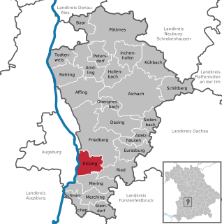
Kissing is a municipality in the Aichach-Friedberg district, in Bavaria, Germany. It is located just 10 km south of Augsburg and has about 11,200 inhabitants (2007).

Unterföhring is a municipality in Upper Bavaria. It lies adjacent to the northeast side of Munich, and is one of the nearest suburbs to Munich's central district.

Neufahrn bei Freising is a municipality in the district of Freising, in Bavaria, Germany. It has about 20,000 inhabitants and is located near the river Isar, 12 km southwest of Freising and 20 km northeast of Munich.

Feldkirchen-Westerham is a municipality in the district of Rosenheim, in Bavaria, Germany. It is situated 22 km west of Rosenheim.

Hofstetten is a municipality in the district of Landsberg in Bavaria in Germany. It has 1759 inhabitants.

Feldkirchen is a municipality in the district of Munich, Bavaria, Germany. It is located 10 km east of Munich and has 5,987 inhabitants. Feldkirchen was first mentioned in a document dated 853.

Pollenfeld is a municipality in the district of Eichstätt in Bavaria in Germany.

Wellheim is a municipality in the district of Eichstätt in Bavaria in Germany. It lies in the so-called "Urdonautal", the valley the Danube used some 300,000 years ago on its way to the Black Sea. Today a little river, the Schutter flows through the village in the opposite direction. The community consists of 5 villages and has about 2800 inhabitants. Today there is no industry at all but a wonderful landscape with a pure nature.
Althegnenberg is a municipality in the district of Fürstenfeldbruck in Bavaria in Germany. The municipality consists of the villages Althegnenberg, Hörbach and Lindenhof.

Igling is a municipality in the district of Landsberg in Bavaria in Germany.

Valley is a municipality in the district of Miesbach in Bavaria in Germany. The municipality of Valley holds, as of 2006, 2949 inhabitants.

Zangberg is a municipality in the district of Mühldorf in Bavaria in Germany.

Tiefenbach is a municipality in the district of Passau in Bavaria in Germany.

Kiefersfelden is a municipality with about 7000 inhabitants located in the district of Rosenheim in Bavaria in Germany on the border with Tyrol, Austria.

Dittelbrunn is a municipality in the district of Schweinfurt in Bavaria, Germany.

Chiemsee is a municipality in the district of Rosenheim in Bavaria in Germany, named after the lake Chiemsee. It is Bavaria's smallest municipality by area and the second smallest by population.

Schonstett is a municipality in the district of Rosenheim in Bavaria in Germany.

Hawangen is a municipality in the district of Unterallgäu in Bavaria, Germany, with about 1254 inhabitants. Hawangen is situated 5 km (3 mi) east of Memmingen. The town has a municipal association with Ottobeuren.

Sommerhausen is a municipality and market town in the district of Würzburg in Bavaria, Germany.


