Related Research Articles

The Nullarbor Plain is part of the area of flat, almost treeless, arid or semi-arid country of southern Australia, located on the Great Australian Bight coast with the Great Victoria Desert to its north. It is the world's largest single exposure of limestone bedrock, and occupies an area of about 200,000 square kilometres (77,000 sq mi). At its widest point, it stretches about 1,100 kilometres (684 mi) from east to west across the border between South Australia and Western Australia.

Eyre Highway is a 1,664-kilometre (1,034 mi) highway linking Western Australia and South Australia via the Nullarbor Plain. Signed as National Highways 1 and A1, it forms part of Highway 1 and the Australian National Highway network linking Perth and Adelaide. It was named after explorer Edward John Eyre, who was the first European to cross the Nullarbor by land, in 1840–1841. Eyre Highway runs from Norseman in Western Australia, past Eucla, to the state border. Continuing to the South Australian town of Ceduna, it crosses the top of the Eyre Peninsula before reaching Port Augusta.

The Eyre Peninsula is a triangular peninsula in South Australia. It is bounded by the Spencer Gulf on the east, the Great Australian Bight on the west, and the Gawler Ranges to the north.

Eucla is the easternmost locality in Western Australia, located in the Goldfields-Esperance region of Western Australia along the Eyre Highway, approximately 11 kilometres (7 mi) west of the South Australian border. At the 2016 Australian census, Eucla had a population of 53.

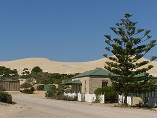
Cocklebiddy is a small roadhouse community located on the Eyre Highway in Western Australia. It is the third stop after Norseman on the journey east across the Nullarbor Plain. The area is noted for its caves and lakes.

Flinders is a single-member electoral district for the South Australian House of Assembly. It is named after explorer Matthew Flinders, who was responsible for charting most of the state's coastline. It is a 58,901 km² coastal rural electorate encompassing the Eyre Peninsula and the coast along the Nullarbor Plain, based in and around the city of Port Lincoln and contains the District Councils of Ceduna, Cleve, Elliston, Lower Eyre Peninsula, Streaky Bay and Wudinna; as well as the localities of Fowlers Bay, Nullarbor and Yalata in the Pastoral Unincorporated Area. The seat was expanded in 2002 to include a western strip of land all the way to the Western Australia border.

Yalata is an Aboriginal community located 200 kilometres (120 mi) west of Ceduna and 140 km (87 mi) south of Ooldea on the edge of the Nullarbor Plain in South Australia. It lies on the traditional lands of the Wirangu people, but the settlement began as Yalata Mission in the early 1950s when Pila Nguru people were moved from Ooldea Mission when that closed, after previously being moved from their land in the Great Victoria Desert owing to nuclear testing by the British Government.

Leslie Gordon Chandler (1888–1980) was an Australian jeweller, vigneron, bird photographer, writer and speaker on natural history, and ornithologist. He became a member of the Royal Australasian Ornithologists Union (RAOU) in 1911 and was Press Correspondent for the RAOU 1914-1916 and again in 1920, war service and disability intervening. From 1920 he was based at Red Cliffs in the Victorian Mallee region. He was instrumental in the establishment of the Hattah-Kulkyne National Park there.

Forrest is a former small railway settlement and stopping place on the Nullarbor Plain, 245 kilometres west of the Western Australia / South Australia state border. It was established in 1916 during construction of the Trans-Australian Railway. The 2016 census recorded no residents. In the 2021 census, the area had "no people or a very low population".

Nullarbor is a locality in the Australian state of South Australia located 295 kilometres (183 mi) to the west of the town of Ceduna in the western part of the state immediately adjoining the border with Western Australia.
Fowlers Bay, formerly known as Yalata, is a bay, town and locality in the Australian state of South Australia located about 658 kilometres (409 mi) north-west of the state capital, Adelaide. The town is located on Port Eyre, at the western end of the larger Fowlers Bay. It was named Yalata after Yalata station, established in the 1860s and stretching from the Nullarbor Plain across to near Streaky Bay on the Eyre Peninsula, whose homestead was located on the hill nearby. The name Yalata now belongs to a small Aboriginal community further west, which was also situated on station land.

Nundroo is a small South Australian town, located approximately 1,014 kilometres (630 mi) west of Adelaide. It is a popular rest stop for travellers due to its location on the Eyre Highway.
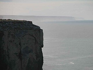
The Bunda Cliffs, also known as the Nullarbor Cliffs, are a coastal scarp on the southern coast of Australia, extending from the western coast of South Australia to the south-eastern corner of Western Australia.

Mundrabilla Land District is a land district of Western Australia, located within the Eucla Land Division on the Nullarbor Plain. It spans roughly 31°00'S - 32°00'S in latitude and 127°30'E - 129°00'E in longitude.

Border Village is a settlement located in South Australia within the locality of Nullarbor on the Eyre Highway at the border with Western Australia.

In Western Australia, Highway 1 is a 5,305-kilometre (3,296 mi) long route around the state, from the South Australian border near Eucla to the Northern Territory border near Kununurra. Highway 1 continues around the rest of Australia, joining all mainland state capitals, and connecting major centres in Tasmania. All roads within the Highway 1 system are allocated a road route numbered 1, M1, A1, or B1, depending on the state route numbering system. In Western Australia, most of the highway is designated as National Route 1; however, the sections in the north-east and south-east of the state that are concurrent with the National Highway routes linking Perth to Adelaide and Darwin are designated as National Highway 1.

Hampton Tableland is a feature that is found at the northern side of the current alignment of the Eyre Highway between Madura and Eucla in Western Australia, at the southern edge of the Nullarbor Plain.
Main Roads Western Australia controls the major roads in the state's Goldfields-Esperance region. While the region is the state's largest, the major roads are restricted to the region's western and southern edges. From the major population centres of Kalgoorlie and Coolgardie, Great Eastern Highway heads west towards Perth via the Wheatbelt ; Coolgardie–Esperance Highway leads south to the port of Esperance via Norseman; and Goldfields Highway proceeds north to Wiluna and then on to the Mid West Region. From Norseman, Eyre Highway takes interstate traffic east across the Nullarbor Plain and into South Australia.
Beverley Clifford was an Australian magazine photographer and photojournalist active during the 1950s-1970s.
The Ironclad Hotel is an Australian pub in Marble Bar in the Pilbara region of Western Australia. Built in the 1890s, it became notorious as the only pub in what was considered the hottest town in Australia, having a weather record that was unchallenged in the 1940s to the 1960s, and only surpassed in new mining towns developed after that time.
References
- ↑ "EAST-WEST ROAD". Great Southern Herald . Vol. XL, no. 2, 074. Western Australia. 1 November 1941. p. 2. Retrieved 26 April 2023– via National Library of Australia.
- ↑ "EAST-WEST ROAD". Coolgardie Miner . Vol. 7, no. 331. Western Australia. 6 November 1941. p. 6. Retrieved 26 April 2023– via National Library of Australia.
- ↑ "FORREST HIGHWAY". The Northern Miner . Queensland, Australia. 29 January 1942. p. 4. Retrieved 26 April 2023– via National Library of Australia.
- ↑ "FORREST HIGHWAY". South Western Advertiser . Vol. 32, no. 1638. Western Australia. 27 March 1942. p. 4. Retrieved 26 April 2023– via National Library of Australia.
- ↑ Greig, John; Greig, Fran (2001). "The Old Eyre Highway" (PDF). TLCC News. pp. 38–43.
- ↑ "Tough Motoring Trial Starts On Saturday". The Newcastle Sun . New South Wales, Australia. 1 July 1954. p. 12. Retrieved 13 January 2020– via Trove.
- ↑ "Smooth 340-mile run to Kalgoorlie". The Courier-mail . Queensland, Australia. 17 July 1954. p. 3. Retrieved 13 January 2020– via Trove.
- ↑ "THE OVERLAND TRACK TO COOLGARDIE". South Australian Register . South Australia. 29 May 1894. p. 5. Retrieved 21 January 2020– via Trove.
- ↑ "Water-train smash on the Nullarbor". The Sun . New South Wales, Australia. 7 March 1943. p. 3. Retrieved 21 January 2020– via Trove.
- ↑ "NULLARBOR PLAIN". Lachlander And Condobolin And Western Districts Recorder . New South Wales, Australia. 1 September 1947. p. 4. Retrieved 21 January 2020– via Trove.
- ↑ "FROM NORSEMAN TO EUCLA". The West Australian . Western Australia. 5 December 1906. p. 2. Retrieved 21 January 2020– via Trove.
- ↑ Photograph of Madura tank -"water catchment" - "Ten Thousand Miles Round Australia". The Herald . Victoria, Australia. 2 January 1937. p. 35. Retrieved 21 January 2020– via Trove.
- ↑ "Water-train smash on the Nullarbor". The Sun . New South Wales, Australia. 7 March 1943. p. 3. Retrieved 21 January 2020– via Trove.
- ↑ "THE NULLARBOR PLAIN". Great Southern Herald . Western Australia. 16 November 1929. p. 8. Retrieved 21 January 2020– via Trove.
- ↑ "WATER RATION IN NULLARBOR". The Daily Telegraph . New South Wales, Australia. 23 January 1952. p. 11. Retrieved 21 January 2020– via Trove.
- ↑ Transport - Road - Ivy Tanks Cafe and petrol station stop for Truckies, Ivy Tanks, Eyre Highway, Western Australia, 1968 ( photograph by K. Fellowes ) CATEGORY: Photograph PRINCIPAL CREDIT: Australian News and Information Bureau FORMAT: b&w negative TYPE: cellulose acetate STATUS: preservation material, 1968, retrieved 12 January 2020
- ↑ Cities and towns - Township of Ivy Tanks, 1043 miles from Perth and 661 from Adelaide CATEGORY: Photograph PRINCIPAL CREDIT: Australian News and Information Bureau FORMAT: b&w negative TYPE: cellulose acetate STATUS: preservation material, 1968, retrieved 12 January 2020
- ↑ Hurley, Frank (1910), Tanks on the Nullarbor Plain [Western Australia] , retrieved 12 January 2020
- ↑ Australian Geographical Society (1 April 1964), "FRIENDLY HIGHWAY (1 April 1964)", Walkabout, Australian National Travel Association, 30 (4), ISSN 0043-0064
- ↑ Australian Geographical Society (1 May 1974), "HENRIETTA AND THE TERROR (1 May 1974)", Walkabout, Australian National Travel Association, 40 (5), ISSN 0043-0064
- ↑ Hulme, Alan (2 August 1966), $8,000,000 transcontinental telecommunication link , retrieved 13 January 2020
- ↑ Australian Geographical Society (1 June 1969), "Communications Across the Nullarbor (1 June 1969)", Walkabout, Australian National Travel Association, 35 (6), ISSN 0043-0064
- ↑ "MALLABIE TANKS REPAIRED". The Advertiser . South Australia. 6 May 1930. p. 16. Retrieved 13 January 2020– via Trove.
- ↑ Kennedy, Alexander Lorimer (1914), Tent pitched near Mallabie shed tank, South Australia, October 1914 , retrieved 13 January 2020
- ↑ Gundalabbie shed and tanks on the Nullarbor Plains, 1958, retrieved 13 January 2020
- ↑ "Their home is on the East-West road". Sunday Times (Perth) . Western Australia. 9 January 1955. p. 43. Retrieved 13 January 2020– via Trove.
- ↑ "THE MAIL STEAMERS". The Advertiser . South Australia. 27 May 1898. p. 5. Retrieved 13 January 2020– via Trove.
- ↑ "Untitled". The Observer . South Australia. 30 October 1930. p. 5. Retrieved 13 January 2020– via Trove.