
Elland is a market town in Calderdale, in the county of West Yorkshire, England. It is situated south of Halifax, by the River Calder and the Calder and Hebble Navigation. Elland was recorded as Elant in the Domesday Book of 1086. It had a population in 2001 of 14,554, with the ward being measured at 11,676 in the 2011 Census.
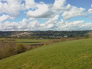
Greetland is a village in the metropolitan borough of Calderdale in West Yorkshire, England. The appropriate Calderdale Ward is called Greetland and Stainland. The population of this ward at the 2011 Census was 11,389. It is located 1 mile (1.6 km) west of Elland and 2.5 miles (4.0 km) south of Halifax.

Calderdale is a metropolitan borough of West Yorkshire, England, which had a population of 211,439. It takes its name from the River Calder, and dale, a word for valley. The name Calderdale usually refers to the borough through which the upper river flows, while the actual landform is known as the Calder Valley. Several small valleys contain tributaries of the River Calder. The main towns of the borough are Brighouse, Elland, Halifax, Hebden Bridge, Sowerby Bridge and Todmorden.

Mangotsfield is a village and former civil parish in the unitary authority area of South Gloucestershire, in the ceremonial county of Gloucestershire, England, to the north-east of Bristol.

Stow Bedon is village and former civil parish, now in the parish of Stow Bedon and Breckles, in the Breckland district of the English county of Norfolk. Stow Bedon adjoins the hamlet of Lower Stow Bedon, although the two are often considered to be one village. In the south of the parish is the village of Breckles. In 2011 the merged parish had a population of 290.
Theakston is a village and civil parish in the Hambleton district of North Yorkshire, England. The population of the civil parish at the 2011 census was 143.

Easington is a village in the Loftus civil parish and is part of the North York Moors National Park. It is in the borough of Redcar and Cleveland, North Yorkshire, England. The village is situated on the A174 road, 1 mile (1.6 km) east of Loftus, 8 miles (13 km) east of Guisborough, and 10 miles (16 km) north-west of Whitby.
Treyford is a hamlet, Anglican parish and former civil parish, now in the civil parish of Elsted and Treyford, in the Chichester district of West Sussex, England. The hamlet sits on the Elsted to Bepton Road 4 miles (6.4 km) southwest of Midhurst. In 1931 the civil parish had a population of 104.

Outlane is a village in Kirklees, West Yorkshire, England, situated approximately 2.5 miles (4 km) south-west of Elland, 3.7 miles (6 km) north-west of Huddersfield and 4.5 miles (7 km) south of Halifax.

Wotton is a suburb of Gloucester, in the unparished area of Gloucester, in the Gloucester district, in the county of Gloucestershire, England. It is situated close to the city centre, the Royal Hospital, the city's railway station and to London Road.

Brookthorpe is a village and former civil parish, now in the parish of Brookthorpe-with-Whaddon, in the Stroud district, in the county of Gloucestershire, England. In 1931 the parish had a population of 194. It has a church called St Swithun's Church.
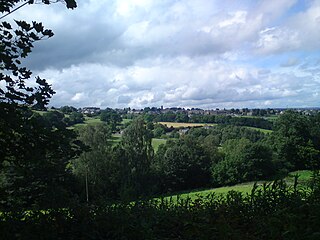
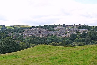
Stainland is a village in the civil parish of Stainland and District, in Calderdale, West Yorkshire, England. The village is part of the Greetland and Stainland ward of Calderdale Council and is approximately 2 miles (3 km) west of Elland, 3.5 miles (6 km) south of Halifax and 4.3 miles (7 km) north-west of Huddersfield.

Barkisland is a village in Calderdale, West Yorkshire, England. Historically part of the West Riding of Yorkshire, it is 1 mile (1.6 km) east of Ripponden, 2 miles (3.2 km) south of Sowerby Bridge and 4 miles (6.4 km) south-west of Halifax town centre.
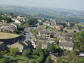
Sowood is a village in the civil parish of Stainland and District, in the Calderdale district, in the county of West Yorkshire, England. The village falls within the Greetland and Stainland ward of Calderdale Council. It is approximately 2.3 miles (3.7 km) south-west of Elland, 4.1 miles (6.6 km) north-west of Huddersfield and 4.2 miles (6.8 km) south of Halifax.
Holywell Green is a village in the civil parish of Stainland and District, in the Calderdale, district, in the county of West Yorkshire, England. The village is situated approximately 1.4 miles (2 km) south-west of Elland, 3.3 miles (5 km) south of Halifax and 3.9 miles (6 km) north-west of Huddersfield. Holywell Green is part of the Greetland and Stainland Ward of Calderdale Council.
Newton on the Moor is a village and former civil parish in Northumberland, England. It is located 5 miles (8 km) south of Alnwick, on the old route of the A1 road although the village has now been bypassed just to the east. The village is now in the civil parish of Newton on the Moor and Swarland, which also includes the village of Swarland, south-west of Newton on the Moor. The population of Newton on the Moor and Swarland parish in 2001 was 822, increasing to 905 at the 2011 Census. The village is a conservation area.

West Vale is a village in Calderdale, West Yorkshire, England. The village falls within the Greetland and Stainland parish of the Calderdale Council. It is 2.5 miles (4.0 km) south of Halifax, 2 miles (3.2 km) west of Elland and 4 miles (6.4 km) north-west of Huddersfield.

Flasby is a hamlet in the Yorkshire Dales in North Yorkshire, England. It is one of the two settlements, with Winterburn, in the civil parish of Flasby with Winterburn, part of the Craven district. The population of the civil parish was estimated at 80 in 2012, measured at 207 in the 2011 Census.

Rokeby is a civil parish about 2.5 miles from Barnard Castle, in the County Durham district, in the ceremonial county of Durham, England. The parish includes the hamlet of Greta Bridge. In 2011 the parish had a population of 158. The parish touches Barningham, Boldron, Bowes, Brignall, Egglestone Abbey, Westwick, Whorlton and Wycliffe with Thorpe. The A66 runs through the area. Rokeby shares a parish council with Brignall and Egglestone Abbey called "Rokeby, Brignall & Egglestone Abbey Parish Council".

Stainland and District is a civil parish in the Metropolitan Borough of Calderdale in West Yorkshire, England. The main settlements in the parish are Stainland, Holywell Green and Sowood. Other settlements include Jagger Green, Old Lindley and Sowood Green. The parish also covers part of Outlane.

