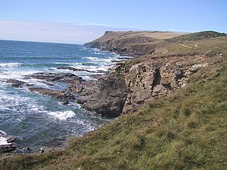
Pentire Head is a headland and peninsula on the Atlantic coast in North Cornwall, England, and is about one mile square. The headland projects north-west with Pentire Point at its north-west corner and The Rumps promontory at its north-east corner.

Lathkill Dale is the valley of the River Lathkill near Bakewell, Derbyshire in the Peak District of England. The river emerges into the dale from springs below Lathkill Head Cave. Towards the head of the dale is the side valley Cales Dale.
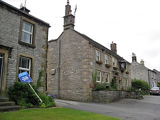
Great Longstone with Little Longstone is one of two villages in the local government district of Derbyshire Dales in Derbyshire, England. The population as taken at the 2011 Census was 843.
Prestongrange Museum is an industrial heritage museum at Prestongrange between Musselburgh and Prestonpans on the B1348 on the East Lothian coast, Scotland. Founded as the original site of the National Mining Museum, its operation reverted to East Lothian Council Museum Service in 1992.

Little Hucklow is a village and civil parish in Derbyshire. Whilst it is a separate civil parish in the Derbyshire Dales District, the Parish Council is joint with Great Hucklow, and Grindlow. The parish consists of the village of Little Hucklow and the hamlets of Coplow Dale and Windmill.

Eylesbarrow mine was a tin mine on Dartmoor, Devon, England that was active during the first half of the 19th century. In its early years it was one of the largest and most prosperous of the Dartmoor tin mines, along with Whiteworks and the Birch Tor and Vitifer mines. Its name has several variant spellings, such as Eylesburrow, Ailsborough, Ellisborough, Hillsborough etc. It was also known as Wheal Ruth for a short period around 1850. The extensive remains lie to the north of the River Plym, less than 1 mile (1.6 km) north-east of Drizzlecombe, on the southern shoulder of the hill called Eylesbarrow on top of which are two prominent Bronze Age barrows.

The Alderley Edge Mines are located on the escarpment in Alderley Edge, Cheshire. Archaeological evidence indicates that copper mining took place here during Roman times and the Bronze Age, and written records show that mining continued here from the 1690s up to the 1920s. The site was the location of the Alderley Edge Landscape Project and the Pot Shaft Hoard.
Sundown Tin and Copper Mine is a heritage-listed mine at Little Sundown Creek, Stanthorpe, Southern Downs Region, Queensland, Australia. It was built from c. 1897 to 1920s. It was added to the Queensland Heritage Register on 28 July 2000.

Bowen Consolidated Colliery is a heritage-listed former mine at Station Street and Second Avenue, Scottville, Whitsunday Region, Queensland, Australia. It was established in 1919. It is also known as No. 1 Underground Mine and Bowen Consolidated Coal Company Colliery. It was added to the Queensland Heritage Register on 3 December 2009.
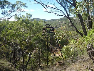
Vulcan Mine is a heritage-listed former mine at Mareeba Mining District, Irvinebank, Shire of Mareeba, Queensland, Australia. It was built from c. 1889 to 1930s. It was added to the Queensland Heritage Register on 21 October 1992.

Totley Township is a heritage-listed mining camp at Charters Towers Mining District, Ravenswood, Charters Towers Region, Queensland, Australia. It was built from c. 1883 to c. 1964. It is also known as Great Extended Mill, Great Extended Mine, and King's New Mill & Tramway. It was added to the Queensland Heritage Register on 21 October 1992.
Einasleigh Copper Mine and Smelter is a heritage-listed mine at Daintree Road, Einasleigh, Shire of Etheridge, Queensland, Australia. It was built from 1867 to 1922. It is also known as Lynd Copper Mine and New Einasleigh Copper Mine. It was added to the Queensland Heritage Register on 11 December 2006.

Mount Isa Mine Early Infrastructure is a heritage-listed group of mining infrastructure on the Mount Isa Mine Lease, Mount Isa (locality), City of Mount Isa, Queensland, Australia. They comprise the Lawlor Shaft & Winding Plant, the Urquhart Shaft and Headframe, the Mount Isa Mine Experimental Dam, and the Mount Isa Mine Power Station. They were built from 1924 to c. 1963. They were added to the Queensland Heritage Register on 25 February 2005.

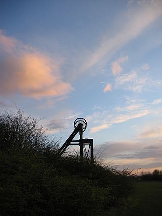
Magpie Mine is a well-preserved disused lead mine near the village of Sheldon in Derbyshire, England, in the parish of Ashford in the Water. The walled enclosure of five lead mines is a protected Scheduled Monument.

Harboro' Rocks is a dolomitic limestone hill near the village of Brassington in the Derbyshire Peak District. The summit is 379 metres (1,243 ft) above sea level with views across to Carsington Water.

Eyam Moor is a plateau-topped hill between the villages of Eyam and Hathersage in Derbyshire, in the Peak District of England. The summit of Sir William Hill is 429 metres (1,407 ft) above sea level.
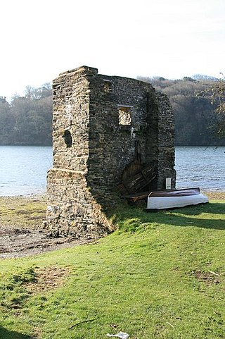
Carnon Mine was a tin mine at Restronguet Creek, near the village of Devoran in Cornwall, England. A ruined engine house survives on the north bank of the creek. It is a Grade II listed building.

Wheal Trewavas was a copper mine in Cornwall, England, about 1.5 miles (2.4 km) west of Porthleven. The ruined engine houses remain, on sea cliffs overlooking Mount's Bay, just east of Trewavas Head. The site is a Scheduled Monument.

Bradwell Moor is a moorland hill above the village of Bradwell, Derbyshire in the Peak District. The summit is 471 metres (1,545 ft) above sea level.

Killifreth Mine was a mine near Chacewater in Cornwall, England, producing at various periods copper, tin and arsenic. The engine house over Hawke's Shaft is a Grade II listed building; it has the tallest surviving chimney in Cornwall.

