
Andravida is a town and a former municipality in Elis, in the northwest of the Peloponnese peninsula of Greece. Since the 2011 local government reform it is part of the municipality Andravida-Kyllini, of which it is a municipal unit. The municipal unit has an area of 40.728 km2. Its population is about 3,700. The town was the capital of the Frankish Principality of Achaea in the late Middle Ages.
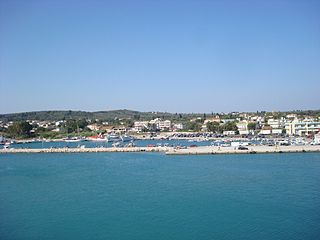
Kastro-Kyllini is a former municipality in Elis, West Greece, Greece. Since the 2011 local government reform it is part of the municipality Andravida-Kyllini, of which it is a municipal unit. The municipal unit has an area of 49.322 km2. The population was 3,272 in 2021. The municipality Kastro-Kyllini was created in 1999 as part of the Kapodistrias reform from the formerly independent communities Kyllini, Kato Panagia, Kastro and Neochori, that became municipal districts. After the 2011 Kallikratis reform, these municipal districts became (dependent) communities. Its seat of administration was the small port town of Kyllini.
Amaliada is a town and a former municipality in northwestern Elis, West Greece, Greece. Since the 2011 local government reform it is part of the municipality Ilida, of which it is the seat and a municipal unit. The municipal unit has an area of 251.945 km2. It is near the archaeological site of Elis, the city-state whose territory was the site of the ancient Olympic Games. It is situated in the plains of Elis, 6 km from the Ionian Sea. It is 10 km southeast of Gastouni, 16 km northwest of Pyrgos and 60 km southwest of Patras.

Vrachnaiika is a town and a former municipality in Achaea, West Greece, Greece. Since the 2011 local government reform it is part of the municipality Patras, of which it is a municipal unit. The municipal unit has an area of 32.111 km2. It is suburb of a Patras, about 11 km southwest of the city centre, on the Gulf of Patras coast. The community has a disused rail station on the line from Patras to Pyrgos. The Greek National Road 9 passes south of the centre.

Gastouni is a town and a former municipality in Elis, West Greece, Greece. Since the 2011 local government reform it is part of the municipality Pineios, of which it is the seat and a municipal unit. The municipal unit has an area of 59.325 km2. Gastouni is situated in a flat rural area, 5 km from the Ionian Sea. The river Pineios flows into the sea near Gastouni. The town is 6 km (4 mi) south of Andravida, 4 km (2 mi) east of Vartholomio, 11 km (7 mi) northwest of Amaliada and 26 km (16 mi) northwest of Pyrgos. The Greek National Road 9/E55 and the railway from Patras to Pyrgos pass east of Gastouni. There is a 12th-century Byzantine church in the southwestern quarter Katholiki.
Vartholomio is a town and a former municipality in Elis, West Greece, Greece. Since the 2011 local government reform it is part of the municipality Pineios, of which it is a municipal unit. The municipal unit has an area of 60.696 km2. The municipal unit covers the southern part of the hilly Kyllini peninsula, and the plains to the southeast. The town Vartholomio is in the plains, on the right bank of the river Pineios, which flows into the Ionian Sea south of the town.

Pyrgos is a city in the northwestern Peloponnese, Greece, capital of the regional unit of Elis and the seat of the Municipality of Pyrgos. The city is located in the middle of a plain, 4 kilometres from the Ionian Sea. The river Alfeios flows into sea about 7 km (4 mi) south of Pyrgos. The population of the town Pyrgos is 26,052, and of the municipality 45,365 (2021). Pyrgos is 16 km (10 mi) west of Olympia, 16 km (10 mi) southeast of Amaliada, 70 km (43 mi) southwest of Patras and 85 km (53 mi) west of Tripoli.

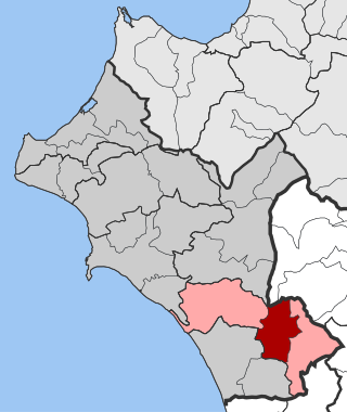
Andritsaina is a village, a community and a former municipality in Elis, West Greece, Greece. Since the 2011 local government reform it is part of the municipality Andritsaina-Krestena, of which it is a municipal unit. The municipal unit has an area of 131.247 km2.
Zacharo is a town and municipality in western Peloponnese, Greece. Administratively, it belongs to the regional unit of Elis in West Greece. Zacharo is situated on the coast of the Gulf of Kyparissia, a part of the Ionian Sea. The mountain Lapithas is to the north, and the Minthi is to the east. Northwest of the town, between mount Lapithas and the sea, is the Kaiafas Lake. Zacharo is 18 km south of Olympia, 28 km southeast of Pyrgos, 65 km northwest of Kalamata and 65 km west of Tripoli. The town is crossed by the Greek National Road 9/E55, that links Patras with Kalamata.

Foloi is a village and a former municipality in Elis, West Greece, Greece. Since the 2011 local government reform it is part of the municipality Archaia Olympia, of which it is a municipal unit. The municipal unit has an area of 174.202 km2. The seat of the municipality was in the village Lalas, in the southern part of the municipal unit. The village Foloi is situated in the northwestern part. Foloi is situated in a mountainous, sparsely populated area. The Foloi oak forest is located in the municipal unit. Foloi is located about 15 km northeast of Olympia, 30 km east of Pyrgos and 55 km south of Patras. It borders on Arcadia to the east, across the river Erymanthus.
Alifeira is a mountain village and a former municipality in Elis, West Greece, Greece. Since the 2011 local government reform it is part of the municipality Andritsaina-Krestena, of which it is a municipal unit. The municipal unit has an area of 96.678 km2. The seat of the municipality was in the village of Kallithea.

Gortyna, is a former municipality in Arcadia, Peloponnese, Greece. Since the 2011 local government reform it is part of the municipality Megalopoli, of which it is a municipal unit. The municipal unit has an area of 116.205 km2. Its seat was in the village Karytaina. The name of the municipality was taken from the ancient city of Gortys.

Magoula is a suburban town of Athens and former community of West Attica, Greece. Since the 2011 local government reform, it is part of the municipality Elefsina, of which it is a municipal unit. The municipal unit has an area of 18.134 km2.
Vounargo is a village in the municipal unit of Iardanos, Elis, Greece. Since the 2011 local government reform it is part of the municipality Pyrgos. Vounargo was the seat of the former municipality Iardanos. It is situated at the foot of low hills to the north. It is 8 km northwest of Pyrgos, 9 km southeast of Amaliada and 11 km west of Karatoula.

Figaleia is a mountain village and a former municipality in Elis, West Greece, Greece. Since the administrative reform of 2011 it is a municipal unit of the municipality of Zacharo. The municipal unit has an area of 89.175 km2. In 2021 the population was 50 for the village and 1,250 for the municipal unit. The seat of the municipality was in Nea Figaleia. Figaleia is located south of Andritsaina, west of Megalopoli, north-northwest of Kalamata, northeast of Kyparissia and southeast of Pyrgos. Figaleia is located in mountainous southern Elis. The river Neda flows through the municipal unit. The name was taken from the ancient city-state of Phigaleia, which was located near the present village.
Karya is a former municipality on the island of Lefkada, Ionian Islands, Greece. Since the 2011 local government reform it is part of the municipality Lefkada, of which it is a municipal unit. It lies in the central part of Lefkada. It has a land area of 30.867 km2. A large part of the population live in the former municipal seat, the town of Karyá.

Goumero is a village in the municipal unit of Oleni, Elis, Greece. It is situated on a hillside in the western foothills of the Foloi plateau, at 500 m elevation. It is 2 km southwest of Agia Anna, 5 km northwest of Neraida, 8 km northeast of Karatoula and 13 km north of Olympia.
Agia Anna is a mountain village in the municipal unit of Oleni, Elis, Greece. Agia Anna is built on the slopes of the hill Axofolia, a western spur of the Foloi plateau. In the village square, the elevation is 450 m, and the top of the hill is around 670 m. Agia Anna is 2 km northeast of Goumero, 4 km west of Klindia, 10 km southeast of Simopoulo and 10 km northeast of Karatoula. The area is forested, but suffered damage from the 2007 Greek forest fires.

Karatoula is a village in the municipal unit of Oleni, central Elis, Greece. Karatoula was the seat of the former municipality of Oleni. It is situated in a wide valley between hills, at about 90 m elevation. Karatoula is 1 km north of Magoula, 2 km west of Oleni (village), 2 km east of Charia, 13 km northwest of Olympia and 11 km northeast of Pyrgos. The river Alyseios, also known as Karatoulaiko Potami, flows west of the village.
Charia is a village and a community in the municipal unit of Oleni, Elis, Greece. It is situated in a valley between low hills, at 80 m elevation. It is 2 km west of Karatoula, 4 km east of Ampelonas, and 9 km northeast of Pyrgos.

