
Ubaí is a municipality in the north of the Brazilian state of Minas Gerais. As of 2020 the population was 12,599 in a total area of 821 km2. It became a municipality in 1962.
Varzelândia is a municipality in the north of the Brazilian state of Minas Gerais. As of 2020 the population was 19,305 in a total area of 804 km². It became a municipality in 1962.

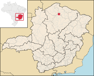
Corinto is a Brazilian municipality in the northeast of the state of Minas Gerais. Its population as of 2020 was 23,668 living in a total area of 2,524 km2. The city belongs to the statistical mesoregion of Central Mineira and to the statistical microregion of Curvelo. It became a municipality in 1923.

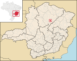
Augusto de Lima is a Brazilian municipality located in the northeast of the state of Minas Gerais. Its population as of 2020 was 4,851 living in a total area of 1,250 km2. The city belongs to the statistical mesoregion of Central Mineira and to the statistical microregion of Curvelo. It became a municipality in 1963.
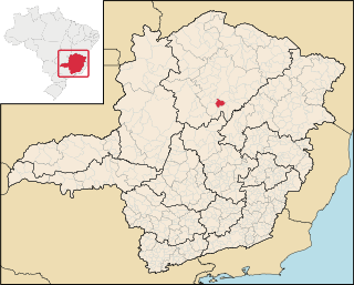
Buenópolis is a Brazilian municipality located in the northeast of the state of Minas Gerais. Its population as of 2020 was 10,353 living in a total area of 1,610 km2. The city belongs to the statistical mesoregion of Central Mineira and to the statistical microregion of Curvelo. It became a municipality in 1938.

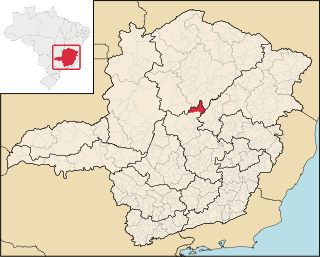
Joaquim Felício is a Brazilian municipality located in the northeast of the state of Minas Gerais. Its population as of 2020 was 4,727 living in a total area of 791 km2. The city belongs to the statistical mesoregion of Central Mineira and to the statistical microregion of Curvelo. It became a municipality in 1962.

Itacambira is a Brazilian municipality located in the north of the state of Minas Gerais. In 2020 the population was 5,417 in a total area of 1,788 km². It became a municipality in 1962.

Claro dos Poções is a Brazilian municipality located in the north of the state of Minas Gerais. In 2020 the population was 7,514 in a total area of 706 km². It became a municipality in 1962.

Glacilândia is a Brazilian municipality located in the north of the state of Minas Gerais. In 2020 the population was 3,164 in a total area of 145 km2. It became a municipality in 1996.

Ibiracatu is a Brazilian municipality located in the north of the state of Minas Gerais. In 2020 the population was 5,369 in a total area of 359 km2. It became a municipality in 1995.

Mirabela is a municipality in the north of the Brazilian state of Minas Gerais. As of 2020 the population was 13,620 in a total area of 721 km2. It became a municipality in 1962.

Patis is a municipality in the north of the Brazilian state of Minas Gerais. As of 2010 the population was 5,579 in a total area of 444 km2. It became a municipality in 1995.

Ponto Chique is a municipality in the north of the Brazilian state of Minas Gerais. As of 2020, the population was 4,283 in a total area of 602 km2. It became a municipality in 1997.

São João da Lagoa is a municipality in the north of the Brazilian state of Minas Gerais. As of 2020 the population was 4,932 in a total area of 990 km2. It became a municipality in 1995.

São João do Pacuí is a municipality in the north of the Brazilian state of Minas Gerais. As of 2020 the population was 4,448 in a total area of 420 km2. It became a municipality in 1997.

Verdelândia is a municipality in the north of the Brazilian state of Minas Gerais. As of 2020 the population was 9,443 in a total area of 1,452 km². It became a municipality in 1997.

Bocaiuva is a Brazilian municipality located in the northwest of the state of Minas Gerais. Its population as of 2020 was 50,256 people living in a total area of 3,232 km2. The city belongs to the mesoregion of North of Minas and to the microregion of Bocaiuva. It became a municipality in 1890.
Engenheiro Navarro is a Brazilian municipality located in the north of the state of Minas Gerais. Its population as of 2020 was 7,241 people living in a total area of 632 km2. The city belongs to the mesoregion of North of Minas and to the microregion of Bocaiúva. It became a municipality in 1962.

Francisco Dumont is a Brazilian municipality located in the north of the state of Minas Gerais. Its population as of 2020 was 5,242 people living in a total area of 1,553 km². The city belongs to the mesoregion of North of Minas and to the microregion of Bocaiúva. It became a municipality in 1962.
Guaraciama is a Brazilian municipality located in the north of the state of Minas Gerais. Its population as of 2020 was 4,989 people living in a total area of 392 km2. The city belongs to the mesoregion of North of Minas and to the microregion of Bocaiúva. It became a municipality in 1997.

