Diamantina, Minas Gerais

Last updated • 6 min readFrom Wikipedia, The Free Encyclopedia
Diamantina
Municipality of Diamantina
Capela do N. Senhor do Bonfim (5132571897).jpg
Igreja de Sao Francisco de Assis, Diamantina, MG.JPG
Diamantina igreja n sra rosario.jpg
Antiga Estacao Ferroviaria (5132567829).jpg
Diamantina - MG (5264743631).jpg
Bandeira diamantina.png
Brasao diamantina.png
MinasGerais Municip Diamantina.svg
Location in Minas Gerais
CountryFlag of Brazil.svg  Brazil
State Bandeira de Minas Gerais.svg  Minas Gerais
Region Southeast
Intermediate Region Teófilo Otoni
Immediate Region Diamantina
Founded6 March 1831
Government
   Mayor Juscelino Brasiliano Roque (DEM)
Area
  Total3 869 km2 (1,493 sq mi)
Population
 (2020) [1]
  Total47,825
  Density12.3/km2 (32/sq mi)
Demonym Diamantinense
Time zone UTC−3 (BRT)
Postal Code
39100-000
Area code
+55 38
HDI (2010)0.716 – high [2]
Website diamantina.mg.gov.br
Official nameHistoric Centre of the Town of Diamantina
TypeCultural
Criteria(ii); (iv)
Designated1999
Reference no. 890
Region South America

Diamantina (Portuguese pronunciation: [dʒiamɐ̃ˈtʃinɐ] ) is a Brazilian municipality in the state of Minas Gerais. Its estimated population in 2020 was 47,825 in a total area of 3,870 km2. [3]

Contents

Arraial do Tijuco (as Diamantina was first called) was built during the colonial era in the early 18th century. As its name suggests, Diamantina was a center of diamond mining in the 18th and 19th centuries. A well-preserved example of Brazilian Baroque architecture, Diamantina is a UNESCO World Heritage Site.

Other historical cities in Minas Gerais are Ouro Preto, São João del-Rei, Mariana, Tiradentes, Congonhas and Sabará.

Statistical micro-region

Diamantina is a statistical micro-region that includes the following municipalities: Diamantina, Datas, Felício dos Santos, Gouveia, Presidente Kubitschek, São Gonçalo do Rio Preto, Senador Modestino Gonçalves, and Couto de Magalhães de Minas. The area of this region is 7,348 km2 and in 2006 the population was 80,063 inhabitants. The population density (2000) was 11.2 inhabitants/km2.

History

Prehistory

Before the arrival of Portuguese settlers, in the 16th century (the first reports give account of expeditions that went up the Jequitinhonha and São Francisco Rivers), Diamantina, like the entire region of the current state of Minas Gerais, was occupied by indigenous peoples of the Macro-Jê languages. [4]

Foundation and exploration of diamonds

Diamantina was founded as Arraial do Tejuco in 1713, with the construction of a chapel that honored the patron Saint Anthony of Padua. The locality had strong growth when the Diamonds were discovered in 1729. At the end of the 18th century, it was the third largest population in the Captaincy General of Minas, behind the capital Vila Rica, today Ouro Preto, and with a population similar to that of the prosperous São João del-Rei.

In the 18th century it grew due to the large local production of diamonds, which were exploited by the Portuguese crown. It was initially known as Arraial do Tejuco (or Tijuco) (from the Tupi tyîuka, "rotten water"), Tejuco and Ybyty'ro'y (Tupi word meaning "cold mountain", by the junction of ybytyra ("mountain").) and ro'y ("cold"). During the 18th century, the city was famous for having sheltered Chica da Silva, a freed slave who was the wife of the richest man in Colonial Brazil, João Fernandes de Oliveira.

Diamantina represented the largest mining of diamonds in the western world in the 18th century, and for nine years, the Portuguese Crown was not aware of the discovery of diamonds in the region, which was done by the governor of the Captaincy, in 1729, the then D. Lourenço de Almeida.

Portugal's response was to impose full control over the diamond regions of Minas Gerais. In 1734, the Intendency of Diamonds was created, whose regime was totally controlling and authoritarian.

The Portuguese Crown's monopoly over diamond deposits lasted until 1845.

Incorporation, transformation into historical heritage and recent history

Diamantina emancipated itself from the municipality of Serro only in 1831, changing its name to Diamantina because of the large volume of diamonds found in the region. The delay was due to the need for greater local control by the colonial authorities, since in the mid-18th century the population was larger than that of Vila do Príncipe do Serro Frio, head of the region. Life in Diamantina at the end of the 19th century was portrayed by Alice Brant in her book Minha Vida de Menina, which became a landmark in Brazilian literature after being rediscovered by Elizabeth Bishop.

Mining for diamonds near Diamantina. River has been diverted by means of the flume shown in the middle ground, and the dried bed is searched for diamonds Diamond mining Diamantina II.jpg
Mining for diamonds near Diamantina. River has been diverted by means of the flume shown in the middle ground, and the dried bed is searched for diamonds

In 1938, Diamantina celebrated its 100th anniversary as a city, receiving the title of "National Historic Heritage" from the National Institute of Historic and Artistic Heritage.

With the arrival of Juscelino Kubitschek to the state government and later to the Presidency of the Republic, many improvements were made in Diamantina, such as the foundation of the Federal School of Dentistry of Diamantina, the Hotel Tijuco, the Júlia Kubitschek State School and the Diamantina Sports Square.

In 1999, it was elevated to the category of "heritage of humanity" by the United Nations Educational, Scientific and Cultural Organization.

Location

Diamantina is located 292 kilometers almost directly north of the state capital, Belo Horizonte, in a mountainous area. The elevation of the municipal seat is 1,114 meters. The Jequitinhonha River, one of Brazil's most important rivers, flows to the east of the municipal seat. Diamantina is linked to the state capital by federal highway BR-259, by way of Curvelo. Diamantina Airport has regular flights to Belo Horizonte.

The municipality contains the 16,999 hectares (42,010 acres) Biribiri State Park, created in 1998, which contains the historic village of Biribiri. [5]

Neighboring municipalities are: Olhos d'Água and Bocaiúva (N); Carbonita, Senador Modestino Gonçalves, São Gonçalo do Rio Preto, and Couto de Magalhaes de Minas (E); Santo Antônio do Itambé, Datas, Serro and Monjolos (S); Augusto de Lima, Buenópolis, and Engenheiro Navarro (W).

Climate

Climate data for Diamantina, Minas Gerais, 1981-2010 normals, extremes 1961-2010
MonthJanFebMarAprMayJunJulAugSepOctNovDecYear
Record high °C (°F)32.7
(90.9)
31.6
(88.9)
31.0
(87.8)
30.2
(86.4)
28.8
(83.8)
27.4
(81.3)
28.2
(82.8)
30.5
(86.9)
33.1
(91.6)
35.8
(96.4)
33.6
(92.5)
31.6
(88.9)
35.8
(96.4)
Mean daily maximum °C (°F)25.8
(78.4)
26.0
(78.8)
25.6
(78.1)
24.6
(76.3)
23.0
(73.4)
21.9
(71.4)
21.4
(70.5)
22.9
(73.2)
24.5
(76.1)
25.5
(77.9)
24.5
(76.1)
24.9
(76.8)
24.2
(75.6)
Daily mean °C (°F)20.6
(69.1)
20.6
(69.1)
20.3
(68.5)
19.3
(66.7)
17.4
(63.3)
16.1
(61.0)
15.7
(60.3)
16.8
(62.2)
18.4
(65.1)
19.7
(67.5)
19.6
(67.3)
20.0
(68.0)
18.7
(65.7)
Mean daily minimum °C (°F)16.8
(62.2)
16.7
(62.1)
16.6
(61.9)
15.6
(60.1)
13.6
(56.5)
11.9
(53.4)
11.3
(52.3)
11.8
(53.2)
13.6
(56.5)
15.3
(59.5)
15.9
(60.6)
16.5
(61.7)
14.6
(58.3)
Record low °C (°F)7.0
(44.6)
11.1
(52.0)
11.8
(53.2)
10.0
(50.0)
5.6
(42.1)
4.6
(40.3)
2.8
(37.0)
6.2
(43.2)
6.7
(44.1)
8.2
(46.8)
6.5
(43.7)
9.9
(49.8)
2.8
(37.0)
Average precipitation mm (inches)236.7
(9.32)
142.7
(5.62)
185.0
(7.28)
76.6
(3.02)
22.9
(0.90)
6.3
(0.25)
4.7
(0.19)
13.2
(0.52)
33.1
(1.30)
118.5
(4.67)
232.7
(9.16)
302.9
(11.93)
1,375.3
(54.16)
Average precipitation days (≥ 1 mm)1311127311249151896
Average relative humidity (%)78.576.179.578.777.174.871.668.267.969.479.181.675.2
Mean monthly sunshine hours 183.7176.5182.9190.5208.4190.9226.3239.2195.0181.6147.5149.82,272.3
Percent possible sunshine 46504955605866685547383752
Source: INMET [6]

Economic activities

The main economic activities are tourism, services, small industry and agriculture. The GDP in 2005 was R$184 million, with 140 million coming from services, 23 million from industry, and 8 million from agriculture. In 2006 there were 1,248 rural producers on 73,000 hectares of land. Only 24 of the establishments had tractors. There were 14,000 head of cattle. [7]

Health and education

The social indicators rank Diamantina in the top tier of municipalities in the state.

[8]

The highest ranking municipality in Minas Gerais in 2000 was Poços de Caldas with 0.841, while the lowest was Setubinha with 0.568. Nationally the highest was São Caetano do Sul in São Paulo with 0.919, while the lowest was Setubinha. In more recent statistics (considering 5,507 municipalities) Manari in the state of Pernambuco has the lowest rating in the country—0,467—putting it in last place. [8]

There were 2 hospitals and 31 health clinics in 2005. Educational needs were met by 30 primary schools and 9 middle schools. [7]

There were 3 institutions of higher learning: Faculdade de Ciências Jurídicas de Diamantina - FCJ (a law school), Faculdade de Filosofia e Letras de Diamantina - FAFIDIA (humanities), and Universidade Federal dos Vales do Jequitinhonha e Mucuri - UFVJM (federal public). [9]

Famous natives of Diamantina

Twin towns – sister cities

Diamantina is twinned with: [10]

Friendly cities

Diamantina also cooperates with Třeboň in the Czech Republic. [11]

Related Research Articles

<span class="mw-page-title-main">Minas Gerais</span> State in Southeastern Brazil

Minas Gerais is one of the 27 federative units of Brazil, being the fourth largest state by area and the second largest in number of inhabitants with a population of 20,539,989 according to the 2022 census. Located in the Southeast Region of the country, it is limited to south and southwest with São Paulo; Mato Grosso do Sul to the west; Goiás and the Federal District to the northwest; Bahia to the north and northeast; Espírito Santo to the east; and Rio de Janeiro to the southeast. The state's capital and largest city, Belo Horizonte, is a major urban and finance center in Brazil, being the sixth most populous municipality in the country while its metropolitan area ranks as the third largest in Brazil with just over 5.8 million inhabitants, after those of São Paulo and Rio de Janeiro. Minas Gerais' territory is subdivided into 853 municipalities, the largest number among Brazilian states.

<span class="mw-page-title-main">Ouro Preto</span> Municipality in Minas Gerais, Brazil

Ouro Preto, formerly Vila Rica, is a Brazilian municipality located in the state of Minas Gerais. The city, a former colonial mining town located in the Serra do Espinhaço mountains, was designated a World Heritage Site by UNESCO due to its Baroque colonial architecture. Ouro Preto used to be the capital of Minas Gerais from 1720 until the foundation of Belo Horizonte in 1897.

<span class="mw-page-title-main">Mariana, Minas Gerais</span> Municipality in Southeast, Brazil

Mariana is the oldest city in the state of Minas Gerais, Brazil. It is a tourist city, founded on July 16, 1696, and retains the characteristics of a baroque city, with its churches, buildings and museums. It was the first capital of Minas Gerais.

<span class="mw-page-title-main">Congonhas</span> Municipality in Southeast Brazil

Congonhas is a historical Brazilian city located in the state of Minas Gerais. It is situated 90 kilometres (56 mi) south from Belo Horizonte, the capital of state of Minas Gerais, by the highway BR-040. As of 2020, the city had a population of 55,309.

<span class="mw-page-title-main">Ponte Nova</span> Municipality in central-eastern Minas Gerais state, Brazil

Ponte Nova is a municipality in central-eastern Minas Gerais state, Brazil.

<span class="mw-page-title-main">Bocaiúva</span> Town in Brazil

Bocaiuva is a Brazilian municipality located in the northwest of the state of Minas Gerais. Its population as of 2020 was 50,256 people living in a total area of 3,232 km2. The city belongs to the mesoregion of North of Minas and to the microregion of Bocaiuva. It became a municipality in 1890.

<span class="mw-page-title-main">Estrada Real</span> Kings street

Estrada Real was an epithet applied to the roads built and maintained by the Portuguese Crown both in Portugal itself and in the Portuguese overseas territories.

<span class="mw-page-title-main">Itamarandiba</span> Municipality in Southeast, Brazil

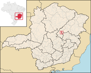
Itamarandiba is a Brazilian municipality located in the north-center of the state of Minas Gerais. Its population as of 2020 was 34,936 living in a total area of 2,736 km2.

<span class="mw-page-title-main">Couto de Magalhães de Minas</span> Municipality in the state of Minas Gerais, Brazil

Couto de Magalhães de Minas is a Brazilian municipality located in the north-center of the state of Minas Gerais. Its population as of 2020 was 4,423 living in a total area of 484 km². The city belongs to the statistical mesoregion of Jequitinhonha and to the statistical microregion of Diamantina. It became a municipality in 1963.

<span class="mw-page-title-main">Datas</span> Brazilian municipality

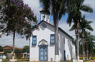
Datas is a Brazilian municipality in the north-center of the state of Minas Gerais. Its population as of 2020 was 5,421 living in a total area of 309 km2. The city belongs to the statistical mesoregion of Jequitinhonha and to the statistical microregion of Diamantina. It became a municipality in 1962.

<span class="mw-page-title-main">Felício dos Santos</span> Human settlement in Brazil

Felício dos Santos is a Brazilian municipality located in the center-north of the state of Minas Gerais. Its population as of 2020 was 4,704 living in a total area of 358 km². The city belongs to the statistical mesoregion of Jequitinhonha and to the statistical microregion of Diamantina. It became a municipality in 1962.

<span class="mw-page-title-main">Gouveia, Minas Gerais</span> Human settlement in Brazil

Gouveia is a Brazilian municipality located in the center of the state of Minas Gerais. Its population as of 2020 was 11,818 living in a total area of 874 km2. The city belongs to the statistical mesoregion of Jequitinhonha and to the statistical microregion of Diamantina. It became a municipality in 1953.

<span class="mw-page-title-main">Presidente Kubitschek</span> Human settlement in Brazil

Presidente Kubitschek is a Brazilian municipality in the state of Minas Gerais. Its population as of 2020 was 3,001 living in a total area of 189 km2. The city belongs to the statistical mesoregion of Jequitinhonha and to the statistical microregion of Diamantina. It became a municipality in 1962.

<span class="mw-page-title-main">São Gonçalo do Rio Preto</span> Human settlement in Brazil

São Gonçalo do Rio Preto is a Brazilian municipality in the state of Minas Gerais. Its population as of 2020 was 3,173 living in a total area of 313 km2.

<span class="mw-page-title-main">Senador Modestino Gonçalves</span> Municipality in Minas Gerais., Brazil

Senador Modestino Gonçalves is a Brazilian municipality in the state of Minas Gerais.

José Joaquim Emerico Lobo de Mesquita was a Brazilian composer, music teacher, conductor and organist.

Mata dos Ausentes Ecological Station is a state-administered ecological station in Minas Gerais, Brazil.

<span class="mw-page-title-main">Biribiri State Park</span>

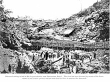
The Biribiri State Park is a state park in the state of Minas Gerais, Brazil. It protects a mountainous region of cerrado. The park contains an abandoned village, once home to workers in a textile factory, which is now a tourist attraction.

<span class="mw-page-title-main">Espinhaço Mosaic</span>

The Espinhaço: Alto Jequitinhonha – Serra do Cabral Mosaic, or simply Espinhaço Mosaic, is a protected area mosaic in the state of Minas Gerais, Brazil.

<span class="mw-page-title-main">Immediate Geographic Region of Diamantina</span> Urban administrative region in Minas Gerais, Brazil

The Immediate Geographic Region of Diamantina is one of the 7 immediate geographic regions in the Intermediate Geographic Region of Teófilo Otoni, one of the 70 immediate geographic regions in the Brazilian state of Minas Gerais and one of the 509 of Brazil, created by the National Institute of Geography and Statistics (IBGE) in 2017.

References

  1. IBGE 2020
  2. "Archived copy" (PDF). United Nations Development Programme (UNDP). Archived from the original (PDF) on July 8, 2014. Retrieved August 1, 2013.{{cite web}}: CS1 maint: archived copy as title (link)
  3. IBGE 2020
  4. "Relação das Comunidades Negras Quilombolas em Minas Gerais". www.cedefes.org.br (in Brazilian Portuguese). Retrieved 2022-01-25.
  5. "Parque Estadual do Biribiri", Descubra Minas (in Portuguese), Senac Minas, archived from the original on 2016-12-01, retrieved 2016-11-30
  6. "Normais Climatológicas do Brasil". National Institute of Meteorology . Retrieved July 19, 2021.
  7. 1 2 IBGE Archived January 9, 2007, at the Wayback Machine
  8. 1 2 Frigoletto
  9. "Mundo Vestibular". Archived from the original on 2016-03-26. Retrieved 2008-07-16.
  10. "Sister Cities of Volusia". volusiasistercitie.wixsite.com. Volusia Sister Cities. Retrieved 2020-11-18.
  11. "Spolupracující města". mesto-trebon.cz (in Czech). Třeboň. Retrieved 2020-11-18.