Volta Grande

Last updated
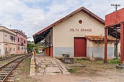
Train station at Volta Grande Volta grande 1.jpg
Train station at Volta Grande

Volta Grande is a Brazilian municipality in the state of Minas Gerais. As of 2020 its population was estimated to be 5,261. [1]

Contents

Geography

Volta Grande is located in the Zona da Mata mesoregion of Minas Gerais near the border with the state of Rio de Janeiro. The city is 352 km (219 mi) by road from the state capital of Belo Horizonte. It lies at an altitude of 210 m (690 ft).

Climate

The climate is tropical with rains during the summer and mean annual temperature around 19 °C (66 °F), with variations between 15 °C (59 °F) (average minimum) and 23 °C (73 °F) (mean maximum).

Hydrography

The rivers Paraiba do Sul and Angu drain the municipality of Volta Grande which is part of the Paraiba do Sul river basin.

History

The town originated from a village formed in 1835 and was elevated to a district of the municipality of Alem Paraíba in 1891. Emancipation came in 1938.

Notable people

It is the birthplace of film director Humberto Mauro.

See also

Related Research Articles

<span class="mw-page-title-main">Municipalities of Brazil</span> State administrative areas in Brazil

The municipalities of Brazil are administrative divisions of the Brazilian states. Brazil currently has 5,570 municipalities, which, given the 2019 population estimate of 210,147,125, makes an average municipality population of 37,728 inhabitants. The average state in Brazil has 214 municipalities. Roraima is the least subdivided state, with 15 municipalities, while Minas Gerais is the most, with 853. Northern states are divided into small numbers of large municipalities, and therefore they cover large areas incorporating several separated cities or towns that do not necessarily conform to one single conurbation. Southern and eastern states on the other hand, are divided into many small municipalities, and therefore large urban areas usually extend over several municipalities which form one single conurbation.

<span class="mw-page-title-main">Campo Grande</span> Capital city of Mato Grosso do Sul, Brazil

Campo Grande is a city in the central and western region of Brazil, capital of the state of Mato Grosso do Sul. Historically a stronghold of separatists from the North and South, founded by José Antônio Pereira, the city is planned in the middle of a vast green space, with wide streets and tree-lined avenues with several gardens along the way. It is one of the most wooded cities in Brazil, with 96.3% of houses in shade.

Lagoa may refer to the following:

<span class="mw-page-title-main">Taubaté</span> Place in southeastern Brazil

Taubaté is a medium-sized city in the state of São Paulo, in southeastern Brazil.

Santana may refer to:

<span class="mw-page-title-main">Belmiro Braga</span> City in the state of Minas Gerais, Brazil

Belmiro Braga is a city in the Brazilian state of Minas Gerais, close to the border with Rio de Janeiro state. It was emancipated from Juiz de Fora in 1962. As of 2020, the estimated population was 3,425 inhabitants.

<span class="mw-page-title-main">Paraíba do Sul</span> River in southeast Brazil

The Paraíba do Sul, or simply Paraíba, is a river in southeast Brazil. It flows 1,137 km (706 mi) west to northeast from its farthest source at the source of the river Paraitinga to the sea near Campos dos Goytacazes. The river receives its name when it meets the river Paraibuna at the Paraibuna dam.

<span class="mw-page-title-main">Leopoldina, Minas Gerais</span> Brazilian municipality

Leopoldina is a Brazilian municipality in the state of Minas Gerais. It belongs to the Zona da Mata mesoregion and it located 322 kilometers southeast of Belo Horizonte, the state capital. In 2022, its estimated population was 51 145 inhabitants, according to IBGE. Its territory covers an area of 943 km2.

<span class="mw-page-title-main">Lima Duarte, Minas Gerais</span> Municipality in Southeast, Brazil

Lima Duarte is a municipality in the state of Minas Gerais, Brazil. It has a population of 16,724 inhabitants (2020) and a total area of 848 square kilometres (327 sq mi) and lies at an elevation of 860 metres (2,822 ft) in the foothills of the Mantiqueira Mountains. It was given city status in 1881.

<span class="mw-page-title-main">Alto Paraná Atlantic forests</span>

The Alto Paraná Atlantic forests, also known as the Paraná-Paraíba interior forests, is an ecoregion of the tropical moist forests biome, and the South American Atlantic Forest biome. It is located in southern Brazil, northeastern Argentina, and eastern Paraguay.

<span class="mw-page-title-main">Indaiabira</span> Municipality in the northeast of the Brazilian state of Minas Gerais

Indaiabira is a municipality in the northeast of the Brazilian state of Minas Gerais. As of 2020 the population was 7,339 in a total area of 1,008 km². The elevation is 857 meters. It became a municipality in 1997.

<span class="mw-page-title-main">Guarda-Mor</span> Town and municipality in the state of Minas Gerais, Brazil

Guarda-Mor is a municipality in the north of the Brazilian state of Minas Gerais. Its population in 2020 was 6,569 inhabitants in a total area of 2,066 km2. It is a large producer of cattle and grains, especially soybeans.

<span class="mw-page-title-main">Delta, Minas Gerais</span> Municipality in Minas Gerais, Brazil

Delta is a Brazilian municipality located in the west of the state of Minas Gerais. Its population as of 2020 was estimated to be 10,768 people living in a total area of 104 square kilometres (40 sq mi). The city belongs to the mesoregion of Triângulo Mineiro and Alto Paranaíba and to the micro-region of Uberaba. It became a municipality in 1997.

<span class="mw-page-title-main">Ibiá</span> Town and municipality in the state of Minas Gerais, Brazil

Ibiá is a Brazilian municipality located in the west of the state of Minas Gerais. Its population as of 2020 was estimated to be 25,358 people living in a total area of 2,707 km². The city belongs to the mesoregion of Triângulo Mineiro and Alto Paranaíba and to the micro-region of Araxá. It became a municipality in 1923.

<span class="mw-page-title-main">São José da Barra</span> Brazilian municipality located in the southwest of the state of Minas Gerais

São José da Barra is a Brazilian municipality located in the southwest of the state of Minas Gerais. Its population as of 2020 was 7,480 people living in a total area of 312 km2. The city belongs to the meso-region of Sul e Sudoeste de Minas and to the micro-region of Passos. It became a municipality in 1948. The important hydroelectric plant of Furnas is located here.

<span class="mw-page-title-main">Pirapetinga</span> Municipality in Southeast, Brazil

Pirapetinga is a municipality in the state of Minas Gerais in the Southeast region of Brazil. Its estimated population in 2020 was 10,772 inhabitants (IBGE).

The Angu River is a river in the Brazilian state of Minas Gerais. It is a left bank tributary of the Rio Paraiba do Sul. It is 58 km (36 mi) in length and drains an area of 346 km2 (134 sq mi) .

The Brazilian municipal elections of 2012 took place on October 7 and on October 28. Over 138 million voters chose mayors, deputy mayors and city councillors for the 5,568 municipalities of Brazil. These were the first elections in which the recently registered parties Partido Pátria Livre (PPL) and Partido Social Democrático (PSD) participated; they were both recognized by the Superior Electoral Court in 2011. Political parties whose candidates wished to run for the 2012 elections had to be registered at the TSE for at least one year before the election date, while candidates also had to be affiliated to a party for the same period of time. Conventions for the selection of candidates within the parties occurred between 10 and 30 June, while the registry of candidates and alliances with the Regional Electoral Courts took place until July 5. Electoral campaign was authorized from the moment a candidacy had been registered. The free electoral program – two daily slots on free-to-air TV and radio for political advertising paid by the Electoral Justice fund – ran weekdays from 21 August until 4 October. According to the current Brazilian electoral law, the two-round system – should the leading candidate receive less than 50% +1 of the votes – is only available for cities with more than 200,000 voters. This includes all state capitals, with the exception of Boa Vista, Roraima and Palmas, Tocantins, plus 59 other municipalities. The free electoral program for the second round ran from 13 October until 26 October.

References

21°46′15″S42°32′20″W / 21.77083°S 42.53889°W / -21.77083; -42.53889