Resende Costa

Last updated
Resende Costa
Municipality of Resende Costa
Igreja Matriz de Resende Costa.jpg
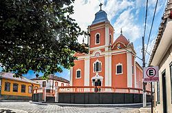
Mother Church of Resende Costa
Bandeira-resende-costa-mg.jpg
Brasao-rc.PNG
MinasGerais Municip ResendeCosta.svg
Location in Minas Gerais
CountryFlag of Brazil.svg  Brazil
State Bandeira de Minas Gerais.svg  Minas Gerais
Region Southeast
Intermediate Region Barbacena
Immediate Region São João del-Rei
Founded2 June 1912
Government
   Mayor José Gouvea Filho (PSDB)
Area
  Total618.312 km2 (238.732 sq mi)
  [1]
Elevation
[2]
1,026 m (3,366 ft)
Population
 (2021) [1]
  Total11,578
  Density19/km2 (48/sq mi)
Demonym resende-costense
Time zone UTC−3 (BRT)
Postal Code
36340-000 to 36344-999
HDI (2010)0.685 – medium [3]
Website resendecosta.mg.gov.br

Resende Costa is a Brazilian municipality located in the state of Minas Gerais. The city belongs to the mesoregion of Campo das Vertentes and to the microregion of Sao Joao del Rei. In 2020, the estimated population was 11,540. [4]

Contents

Geography

According to IBGE (2017), the municipality belongs to the Immediate Geographic Region of São João del-Rei, in the Intermediate Geographic Region of Barbacena. [5]

Ecclesiastical circumscription

The municipality is part of the Roman Catholic Diocese of São João del-Rei. [6]

See also

Related Research Articles

<span class="mw-page-title-main">São Tiago</span> Town and municipality in the state of Minas Gerais, Brazil

São Tiago is a Brazilian municipality in the state of Minas Gerais. As of 2020 its population is estimated to be 10,960.

<span class="mw-page-title-main">São João del-Rei</span> Municipality in Minas Gerais, Brazil

São João del-Rei is a Brazilian municipality in the state of Minas Gerais. Founded in 1713 in homage to king John V of Portugal, the city is famed for its historic Portuguese colonial architecture. The current population is estimated at 90,225 inhabitants.

<span class="mw-page-title-main">Tiradentes, Minas Gerais</span> Municipality in Minas Gerais, Brazil

Tiradentes is a municipality in the Brazilian state of Minas Gerais. It is located at 21°06′37″S44°12′41″W, has an area of 83.5 km², and a maximum elevation above sea level of 927 m. Tiradentes had an estimated population of 10,960, as of 2020. The original village was established in 1702 and became a city on 19 January 1718. In 1889 the city was renamed from Vila de São José do Rio das Mortes in honour of the national hero who was born nearby.

<span class="mw-page-title-main">Carrancas, Minas Gerais</span> Municipality in Southeast, Brazil

Carrancas is a Brazilian municipality located in the south of the state of Minas Gerais. The city belongs to the mesoregion of Campo das Vertentes and to the microregion of Lavras. In 2020 the population was 4,049 in a total area of 728 km².

<span class="mw-page-title-main">Ijaci</span> Town and municipality in the state of Minas Gerais, Brazil

Ijaci is a Brazilian municipality located in the south of the state of Minas Gerais. The city belongs to the mesoregion of Campo das Vertentes and to the microregion of Lavras. The population in 2020 was 6,610 in a total area of 105 km². The regional center, Lavras lies at a distance of 14 kilometers and is connected by paved highway MG-335.

<span class="mw-page-title-main">Ingaí</span> Municipality in Southeast, Brazil

Ingaí is a Brazilian municipality located in the state of Minas Gerais. The city belongs to the mesoregion of Campo das Vertentes and to the microregion of Lavras.

<span class="mw-page-title-main">Luminárias</span> Municipality in Southeast, Brazil

Luminárias is a Brazilian municipality located in the state of Minas Gerais. The city belongs to the mesoregion of Campo das Vertentes and to the microregion of Lavras. In 2020, the estimated population was 5,438.

<span class="mw-page-title-main">Itutinga</span> Town and municipality in the state of Minas Gerais, Brazil

Itutinga is a Brazilian municipality located in the state of Minas Gerais. The city belongs to the mesoregion of Campo das Vertentes and to the microregion of Lavras. In 2020, the estimated population was 3,768.

<span class="mw-page-title-main">Conceição da Barra de Minas</span> Town and municipality in the state of Minas Gerais, Brazil

Conceição da Barra de Minas is a Brazilian municipality located in the state of Minas Gerais. The city belongs to the mesoregion of Campo das Vertentes and to the microregion of Sao Joao del Rei. In 2020, the estimated population was 3,946.

<span class="mw-page-title-main">Coronel Xavier Chaves</span> Municipality in Southeast, Brazil

Coronel Xavier Chaves is a Brazilian municipality located in the state of Minas Gerais. The city belongs to the mesoregion of Campo das Vertentes and to the microregion of São João del-Rei. In 2021, the estimated population was 3,488.

<span class="mw-page-title-main">Lagoa Dourada</span> Municipality in Minas Gerais, Brazil

Lagoa Dourada is a Brazilian municipality located in the state of Minas Gerais.

<span class="mw-page-title-main">Madre de Deus de Minas</span> Town and municipality in the state of Minas Gerais, Brazil

Madre de Deus de Minas is a Brazilian municipality located in the state of Minas Gerais. The city belongs to the mesoregion of Campo das Vertentes and to the microregion of Sao Joao del Rei. In 2020, the estimated population was 5,109.

<span class="mw-page-title-main">Nazareno, Minas Gerais</span> Town and municipality in the state of Minas Gerais, Brazil

Nazareno is a Brazilian municipality located in the state of Minas Gerais. In 2020, the estimated population was 8,179.

<span class="mw-page-title-main">Piedade do Rio Grande</span> Municipality in Minas Gerais, Brazil

Piedade do Rio Grande is a Brazilian municipality located in the state of Minas Gerais. The city belongs to the mesoregion of Campo das Vertentes and to the microregion of Sao Joao del Rei. In 2020, the estimated population was 4,466.

<span class="mw-page-title-main">Prados, Minas Gerais</span> Municipality in Minas Gerais, Brazil

Prados is a Brazilian municipality located in the state of Minas Gerais. The city belongs to the mesoregion of Campo das Vertentes and to the microregion of Sao Joao del Rei. In 2020, the estimated population was 9,080.

<span class="mw-page-title-main">Ritápolis</span> Brazilian municipality

Ritápolis is a Brazilian municipality located in the state of Minas Gerais. The city belongs to the mesoregion of Campo das Vertentes and to the microregion of Sao Joao del Rei. In 2020, the estimated population was 4,562.

<span class="mw-page-title-main">Santa Cruz de Minas</span> Municipality in Southeast, Brazil

Santa Cruz de Minas is a Brazilian municipality located in the state of Minas Gerais. The city belongs to the mesoregion of Campo das Vertentes and to the microregion of Sao Joao del Rei. It is the smallest municipality of Brazil, measuring only 2.9 square kilometres (1.1 sq mi).

<span class="mw-page-title-main">Ibituruna</span> Municipality in Southeast, Brazil

Ibituruna is a municipality in the state of Minas Gerais in the Southeast region of Brazil.

São Vicente de Minas is a municipality in the state of Minas Gerais in the Southeast region of Brazil.

<span class="mw-page-title-main">Immediate Geographic Region of São João del-Rei</span> Immediate geographic region in the Intermediate Geographic Region of Barbacena

The Immediate Geographic Region of São João del-Rei is one of the 10 immediate geographic regions in the Intermediate Geographic Region of Barbacena, one of the 70 immediate geographic regions in the Brazilian state of Minas Gerais and one of the 509 of Brazil, created by the National Institute of Geography and Statistics (IBGE) in 2017.

References

  1. 1 2 "IBGE Resende Costa". IBGE . Retrieved 28 May 2023.
  2. "Município de Resende Costa". cidade-Brasil. Retrieved 28 May 2023.
  3. "Archived copy" (PDF). United Nations Development Programme (UNDP). Archived from the original (PDF) on 8 July 2014. Retrieved 13 March 2022.{{cite web}}: CS1 maint: archived copy as title (link)
  4. IBGE 2020
  5. "Divisões Regionais do Brasil | IBGE". www.ibge.gov.br. Retrieved 2023-02-19.
  6. Silveira, Lucas. "Diocese ganha novo mapa territorial após criação de novas foranias". Diocese de São João del Rei. Retrieved 2023-02-19.

20°55′S44°14′W / 20.917°S 44.233°W / -20.917; -44.233