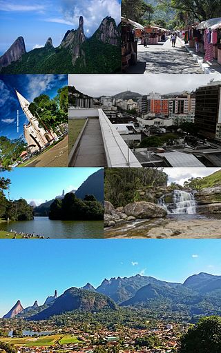
Santos Dumont is a municipality in southern Minas Gerais state, Brazil. The population (2020) is estimated to be 46,421 and the total area of the municipality is 639.1 km2 (246.8 sq mi). It lies at an elevation of 839 m (2,753 ft) just off the main interstate highway, BR040, between the urban centers of Barbacena (north) and Juiz de Fora (south). It is 240 km (150 mi) from the state capital, Belo Horizonte, and 220 km (140 mi) from Rio de Janeiro. It became a city in 1889.

Diamantina is a Brazilian municipality in the state of Minas Gerais. Its estimated population in 2020 was 47,825 in a total area of 3,870 km2.

Nova Lima is a municipality of about 87,000 people, whose downtown is located about 20 kilometers south of Belo Horizonte, the capital of the south-eastern Brazilian state of Minas Gerais. Mining is one of the main economical activities of the city, including the extraction of Iron Ore and Gold. The most famous mine in the city is Morro Velho, a gold mine of 2,700 metres (8,900 ft) depth.
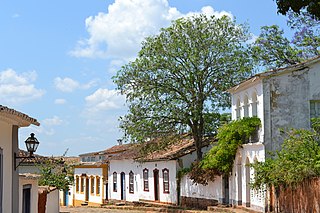
Tiradentes is a municipality in the Brazilian state of Minas Gerais. It is located at 21°06′37″S44°12′41″W, has an area of 83.5 km², and a maximum elevation above sea level of 927 m. Tiradentes had an estimated population of 10,960, as of 2020. The original village was established in 1702 and became a city on 19 January 1718. In 1889 the city was renamed from Vila de São José do Rio das Mortes in honour of the national hero who was born nearby.
Sabará is a Brazilian municipality located in the state of Minas Gerais. The city belongs to the Belo Horizonte metropolitan region and to the associated microregion.

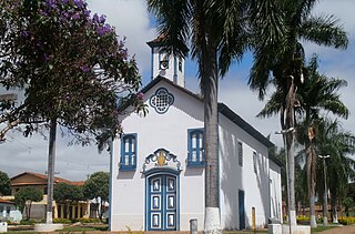
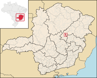
Santo Antônio do Itambé is a municipality in the state of Minas Gerais, Brazil. The population is 3,799 in an area of 305.74 km².
Grão Mogol is a Brazilian municipality located in the north of the state of Minas Gerais. In 2020 the population was 15,890 in a total area of 3,890 km2. The elevation is 829 meters. It became a municipality in 1840.

Itambé do Mato Dentro is a Brazilian municipality located in the state of Minas Gerais. The city belongs to the mesoregion Metropolitana de Belo Horizonte and to the microregion of Conceição do Mato Dentro. As of 2020, the estimated population was 2,056.

Rio Vermelho is a Brazilian municipality located in the state of Minas Gerais. The city belongs to the mesoregion Metropolitana de Belo Horizonte and to the microregion of Conceição do Mato Dentro. As of 2020, the estimated population was 12,739.

Serra Azul de Minas is a Brazilian municipality located in the state of Minas Gerais. The city belongs to the mesoregion Metropolitana de Belo Horizonte and to the microregion of Conceição do Mato Dentro. As of 2020, the estimated population was 4,292.
Couto de Magalhães de Minas is a Brazilian municipality located in the north-center of the state of Minas Gerais. Its population as of 2020 was 4,423 living in a total area of 484 km². The city belongs to the statistical mesoregion of Jequitinhonha and to the statistical microregion of Diamantina. It became a municipality in 1963.

Datas is a Brazilian municipality in the north-center of the state of Minas Gerais. Its population as of 2020 was 5,421 living in a total area of 309 km2. The city belongs to the statistical mesoregion of Jequitinhonha and to the statistical microregion of Diamantina. It became a municipality in 1962.

Presidente Kubitschek is a Brazilian municipality in the state of Minas Gerais. Its population as of 2020 was 3,001 living in a total area of 189 km2. The city belongs to the statistical mesoregion of Jequitinhonha and to the statistical microregion of Diamantina. It became a municipality in 1962.
São Gonçalo do Rio Preto is a Brazilian municipality in the state of Minas Gerais. Its population as of 2020 was 3,173 living in a total area of 313 km².

Catas Altas is a Brazilian municipality located in the state of Minas Gerais. The city belongs to the mesoregion Metropolitana de Belo Horizonte and to the microregion of Itabira. As of 2020, the estimated population was 5,421.

Dionísio is a municipality in the state of Minas Gerais, Brazil. The city belongs to the mesoregion Metropolitana de Belo Horizonte and to the microregion of Itabira. As of 2020, the estimated population was 7,609.
Lambari is a municipality in the state of Minas Gerais in the Southeast region of Brazil.
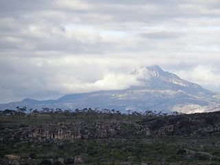
The Pico do Itambé State Park is a state park in the state of Minas Gerais, Brazil. It protects one of the higher peaks in the state.

The Immediate Geographic Region of Diamantina is one of the 7 immediate geographic regions in the Intermediate Geographic Region of Teófilo Otoni, one of the 70 immediate geographic regions in the Brazilian state of Minas Gerais and one of the 509 of Brazil, created by the National Institute of Geography and Statistics (IBGE) in 2017.