Araxá (Portuguese pronunciation: [aɾaˈʃa] ) is a municipality in the state of Minas Gerais, Brazil. It is located approximately 370 kilometers (230 miles) northwest of the state capital Belo Horizonte, with an area of 1,283 square kilometres (495 sq mi), and 3.45 square kilometres (1.33 sq mi) designated as the urban perimeter. [4] As of 2022, the population is 111,691. [5]
It serves as the main city of the Immediate Geographic Region of Araxá, which includes 8 municipalities and as of 2017, spans an area of 9,473.902 square kilometers (3,659.27 square miles) with a population of 176,736 inhabitants. [6]
The name "Araxá" was derived from the Araxás, an amerindian tribe that inhabited the region prior to the European colonization of Brazil, and means "the place where the sun is seen first," or, according to its Tupi origin, "elevated place" or "plateau". [7]
Araxó, an extinct Jê language, was once spoken in the region. [8]
The earliest accounts of the region date back to the second half of the 16th century, when the first encounters with the indigenous people known as the "Araxás" occurred. The Araxás were a native group reportedly led by a warrior named Andaia-Aru, who had separated from their original tribe, known as the "Cataguases". They settled in the extensive region that includes the Serra da Canastra and the Rio Grande, living in relative peace until the mid-17th century, when European settlers arrived, lured by the area's lush forests and abundant mineral waters.
Interactions between the European settlers and the native population were characterized by frequent conflicts, culminating in the extermination of the Araxá people by the settlers following a bandeira expedition led by Campo Inácio Correia de Pamplona (1731–1810), under the colonial administration of the time. Subsequently, much of the region came under the control of the Captaincy of Minas Gerais, which served as the local administrative division of colonial Brazil. [9]
The first farm owners began to establish themselves in the region around 1770. As settlements grew, the area was designated as a parish in 1791, taking the name "São Domingos de Araxá", in honor of Saint Dominic, the founder of the Order of Preachers.
In 1831, São Domingos de Araxá was elevated to the status of a "vila" (town), and it was granted city status on December 19, 1865, due to its local development. The name "Araxá" was officially adopted three years later, in 1868, and has remained in use to this day. [10]
Araxa is bordered by the neighboring municipalities of Perdizes to the north and northwest, Ibiá to the east, Tapira to the south, and Sacramento to the southwest.
The elevation of the city center is 973 metres (3,192 ft). The highest point in the municipality is Serrra da Bocaina at 1,359 metres (4,459 ft), and the lowest point is the Capivara river at 910 metres (2,990 ft). In 2004 the annual average temperature was 20.98 °C (69.76 °F), and the annual rainfall was 1,905 millimetres (75.0 in). [11]
Araxá experiences a tropical savanna climate (Köppen: Aw) with warm temperatures and distinct wet and dry seasons.
The city experiences a wet season from November to April. The dry season extends from May to September, and experiences cooler temperatures than the wet season. [12]
Climate data for Araxá (1991–2020) | |||||||||||||
---|---|---|---|---|---|---|---|---|---|---|---|---|---|
Month | Jan | Feb | Mar | Apr | May | Jun | Jul | Aug | Sep | Oct | Nov | Dec | Year |
Mean daily maximum °C (°F) | 28.3 (82.9) | 28.8 (83.8) | 28.1 (82.6) | 27.8 (82.0) | 26.0 (78.8) | 25.3 (77.5) | 25.5 (77.9) | 27.6 (81.7) | 29.0 (84.2) | 29.4 (84.9) | 27.9 (82.2) | 28.1 (82.6) | 27.7 (81.9) |
Daily mean °C (°F) | 22.6 (72.7) | 22.7 (72.9) | 22.2 (72.0) | 21.6 (70.9) | 19.6 (67.3) | 18.7 (65.7) | 18.7 (65.7) | 20.3 (68.5) | 21.9 (71.4) | 22.8 (73.0) | 22.1 (71.8) | 22.3 (72.1) | 21.3 (70.3) |
Mean daily minimum °C (°F) | 19.0 (66.2) | 18.9 (66.0) | 18.6 (65.5) | 17.6 (63.7) | 15.1 (59.2) | 14.3 (57.7) | 14.1 (57.4) | 15.2 (59.4) | 17.0 (62.6) | 18.3 (64.9) | 18.2 (64.8) | 18.7 (65.7) | 17.1 (62.8) |
Average precipitation mm (inches) | 294.0 (11.57) | 227.1 (8.94) | 206.8 (8.14) | 80.7 (3.18) | 48.6 (1.91) | 17.0 (0.67) | 7.0 (0.28) | 11.8 (0.46) | 60.6 (2.39) | 118.0 (4.65) | 210.3 (8.28) | 285.5 (11.24) | 1,567.4 (61.71) |
Average precipitation days (≥ 1.0 mm) | 16.8 | 13.7 | 14.2 | 7.4 | 3.7 | 1.8 | 1.2 | 1.5 | 5.4 | 9.3 | 14.0 | 18.2 | 107.2 |
Average relative humidity (%) | 79.3 | 77.7 | 79.3 | 75.6 | 72.9 | 69.6 | 63.6 | 57.5 | 59.6 | 67.0 | 76.6 | 80.4 | 71.6 |
Average dew point °C (°F) | 19.1 (66.4) | 19.0 (66.2) | 18.9 (66.0) | 17.8 (64.0) | 15.2 (59.4) | 13.8 (56.8) | 12.5 (54.5) | 12.3 (54.1) | 14.1 (57.4) | 16.6 (61.9) | 18.2 (64.8) | 19.1 (66.4) | 16.4 (61.5) |
Mean monthly sunshine hours | 156.7 | 177.1 | 180.1 | 220.2 | 224.1 | 229.0 | 250.3 | 264.2 | 219.5 | 206.2 | 168.1 | 149.2 | 2,444.7 |
Source: NOAA [12] |
Year | Pop. | ±% |
---|---|---|
1970 | 35,676 | — |
1980 | 53,404 | +49.7% |
1991 | 65,911 | +23.4% |
2000 | 78,997 | +19.9% |
2010 | 93,071 | +17.8% |
2020 | 107,337 | +15.3% |
Source: IBGE |
At the start of the 21st century, the municipality's population was 78,997 in 2000 and increased to 93,071 by 2010. According to the 2022 Brazilian census, the population grew to 111,691, marking an increase of approximately 19.9%.
Race/Skin color | Percentage | Number |
White | 50.18% | 56,048 |
Pardo (Mixed-race) | 38.71% | 43,239 |
Black | 10.78% | 12,042 |
Asian | 0.25% | 283 |
Indigenous | 0.07% | 77 |
Source: IBGE 2022 [13]
Araxá is served by Romeu Zema Airport (IATA: AAX, ICAO: SBAX), located 4 km from the city center.
The city's railway station was inaugurated in 1926 by Estrada de Ferro Oeste de Minas (EFOM). The branch line now serves for only cargo transport and connects the city with the municipalities of Ibiá and Uberaba. Passenger rail services were discontinued in 1979. [14]
The municipality is connected by federal and state highways:
The economy is based on tourism, services, mining, industry, and some agriculture.
Araxá is famous in Brazil for its spa with medicinal mud and mineral waters. One of Brazil's most emblematic hotels, the Grande Hotel, is the center of attraction. Opened in 1944 by governor Benedito Valadares and President Vargas, the Hotel initiated an era of splendor to Araxá and the inland region of the state. It was the stage for huge social, political and cultural events. Overall, the city's hotel sector has 24 establishments offering 2,708 beds (2004). One of Brazil's most famous soap operas, Dona Beija , loosely based on the life of a legendary historic character of the city, was filmed here.
In addition to tourism, the city has a niobium mine. That metal is used in special steels and alloys for jet engine components, rocket sub-assemblies, and heat-resisting and combustion equipment. Reserves are about 460 million tons, sufficient to satisfy current world demand for about 500 years. The largest enterprise in this sector is CBMM—Companhia Brasileira de Metalurgia e Mineração. [11]
Araxá is also a major producer of phosphate concentrate, essential for the production of fertilizers. The most important company in this sector is Vale Fertilizantes S.A., which was acquired by The Mosaic Company in 2018, and operates the largest single superphosphate production plant in Brazil. [15]
In 2005, Araxá recorded a GDP of 1.439 billion Brazilian reais, generated almost equally by the services and industry sectors. During the same period, the workforce included 2,865 employees in industry, 1,478 in construction, 7,636 in commerce, 1,296 in restaurants and hotels, and 2,691 in public administration. The municipality contained 405 rural properties covering a total of 68,000 hectares (170,000 acres). Approximately 1,500 individuals were employed in agriculture. The livestock population comprised 65,000 head of cattle, primarily used for dairy production, with an estimated daily output of 500,000 litres (130,000 US gallons) in 2004. In addition, there was significant production of poultry and swine, and 22 producers of cachaça were registered in 2004. The main agricultural crops included coffee, corn, and soybeans. [16] As of 2021, Araxá reported a GDP of 8.951 billion Brazilian reais, ranking 163rd in Brazil and a GDP per capita of R$ 82.570,25. [17]
In the health sector there were 17 health clinics and 4 hospitals with 244 beds (2005). There were also 6 clinical analysis laboratories and 34 pharmacies. Two of the hospitals were private, and two were philanthropic. The educational needs of 10,500 students were met by 33 primary schools, 11 middle schools, and 40 pre-primary schools. In higher education, there were two institutions: Centro Universitário Planalto de Araxá, and, Universidade do Triângulo Mineiro (UNIT). [18]
In 2004, the healthcare statistics indicated a ratio of one doctor for every 598 inhabitants and an availability of 3.5 hospital beds per 1,000 inhabitants. The infant mortality rate stood at 8.70 deaths per 1,000 live births in the same year, significantly lower than both the state and national averages. For comparison, the infant mortality rate was recorded at 20.80 deaths per 1,000 live births in the year 2000. [11]
In 2023, Araxá ranked 3rd in Minas Gerais and 38th in Brazil for access to education. [20] In the same year, there were 38 schools in the city serving 13,487 elementary school students and 14 schools educating 4,182 high school students. [21]
Belo Horizonte is the sixth-largest city in Brazil, with a population of around 2.3 million, and the third largest metropolitan area, containing a population of 6 million. It is the 13th-largest city in South America and the 18th-largest in the Americas. The metropolis is anchor to the Belo Horizonte metropolitan area, ranked as the third most populous metropolitan area in Brazil and the 17th most populous in the Americas. Belo Horizonte is the capital of the state of Minas Gerais, Brazil's second-most populous state. It is the first planned modern city in Brazil.
Minas Gerais is one of the 27 federative units of Brazil, being the fourth largest state by area and the second largest in number of inhabitants with a population of 20,539,989 according to the 2022 census. Located in the Southeast Region of the country, it is bordered to south and southwest by São Paulo; Mato Grosso do Sul to the west; Goiás and the Federal District to the northwest; Bahia to the north and northeast; Espírito Santo to the east; and Rio de Janeiro to the southeast. The state's capital and largest city, Belo Horizonte, is a major urban and finance center in Brazil, being the sixth most populous municipality in the country while its metropolitan area ranks as the third largest in Brazil with just over 5.8 million inhabitants, after those of São Paulo and Rio de Janeiro. Minas Gerais' territory is subdivided into 853 municipalities, the largest number among Brazilian states.
Uberlândia is a municipality in the state of Minas Gerais, southeastern Brazil. It is the second largest municipality in the state of Minas Gerais after the state capital Belo Horizonte. Its population in 2020 was 699,097, making it the sixth largest city of the interior region of Brazil. The city is located on the Brazilian Highlands 2,802 feet (854 m) above sea level. It is an important logistic hub between São Paulo and Brasília. The city sits within the Brazilian cerrado and has eight protected zones of tropical savanna vegetation.
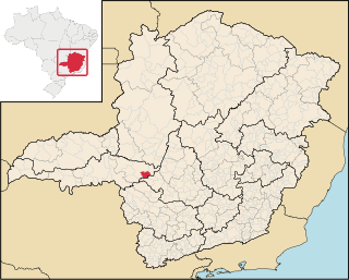
Luz is a Brazilian municipality located in the West part of the state of Minas Gerais. Luz is located between the city of Araxá and the capital city of the state of Minas Gerais, Belo Horizonte. The population is 18,257 in an area of 1172 km2. The city belongs to the Central Mineira region and to the micro-region of Bom Despacho. It became a municipality in 1923.
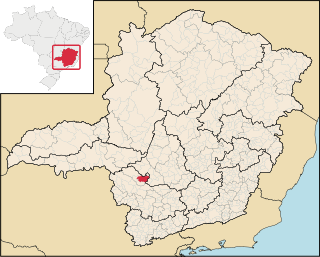
Campos Altos is a Brazilian municipality located in the west of the state of Minas Gerais. Its population as of 2020 was estimated to be 15,563 people living in a total area of 719 km2 (278 sq mi). The city belongs to the mesoregion of Triângulo Mineiro and Alto Paranaíba and to the micro-region of Araxá. It became a municipality in 1944.
Frutal is a municipality in the west of the Brazilian state of Minas Gerais. The population, estimated in 2022 by the IBGE, is of 58.588 inhabitants. The city has an area of 2,426,965km2. Frutal is located in the region known as the "Triângulo Mineiro".
Sacramento is a Brazilian municipality located in the west of the state of Minas Gerais. Its population as of 2020 was 26,374 people living in a total area of 3,071 km2. The city belongs to the meso-region of Triângulo Mineiro and Alto Paranaíba and to the micro-region of Araxá. It became a municipality in 1820.
Bambuí is a Brazilian municipality located in the west of the state of Minas Gerais. Its population as of 2020 was 23,898 people living in a total area of 1,455 square kilometres (562 sq mi), for a density of 15/km2 (39/sq mi). The city belongs to the meso-region of Oeste de Minas and to the micro-region of Piumhi. It became a municipality in 1881.
Prata is a Brazilian municipality located in the west of the state of Minas Gerais. Its population as of 2020 was 28,017, living in a total area of 4,856 km2. The city belongs to the statistical mesoregion of Triângulo Mineiro and Alto Paranaíba and to the statistical microregion of Uberlândia. It became a municipality in 1873.
Itaobim is a municipality in the northeast of the Brazilian state of Minas Gerais. Its population in 2020 was 21,029 inhabitants in a total area of 680 km². It belongs to the Pedra Azul statistical microregion. The elevation of the municipal seat is 180 meters. It became a municipality in 1962. Neighboring municipalities are Medina, Jequitinhonha, Ponto dos Volantes and Itinga. The distance to the state capital, Belo Horizonte is 604 kilometers.
Conquista is a municipality located in the west of Minas Gerais, Brazil. As of 2020, 6,969 inhabitants are estimated to live within the 616 square kilometres (238 sq mi) of Conquista. The city belongs to the mesoregion of Triângulo Mineiro and Alto Paranaíba and to the microregion of Uberaba. Conquista became a municipality in 1912.
Ibiá is a Brazilian municipality located in the west of the state of Minas Gerais. Its population as of 2020 was estimated to be 25,358 people living in a total area of 2,707 km². The city belongs to the mesoregion of Triângulo Mineiro and Alto Paranaíba and to the micro-region of Araxá. It became a municipality in 1923.
Nova Ponte is a Brazilian municipality located in the west of the state of Minas Gerais. Its population as of 2020 was estimated to be 15,800 people living in a total area of 1,105 km². The city belongs to the mesoregion of Triângulo Mineiro and Alto Paranaíba and to the micro-region of Araxá. It became a municipality in 1938.
Pedrinópolis is a Brazilian municipality located in the west of the state of Minas Gerais. Its population as of 2020 was 3,643 people living in a total area of 357 km². The city belongs to the meso-region of Triângulo Mineiro and Alto Paranaíba and to the micro-region of Araxá. It became a municipality in 1962.
Perdizes is a Brazilian municipality located in the west of the state of Minas Gerais. Its population as of 2020 was 16,321 people living in a total area of 2,450 km². The city belongs to the meso-region of Triângulo Mineiro and Alto Paranaíba and to the micro-region of Araxá. It became a municipality in 1938.
Pratinha is a Brazilian municipality located in the west of the state of Minas Gerais. Its population as of 2020 was 3,631 people living in a total area of 619 km². The city belongs to the meso-region of Triângulo Mineiro and Alto Paranaíba and to the micro-region of Araxá. It became a municipality in 1949.
Santa Juliana is a Brazilian municipality located in the west of the state of Minas Gerais. Its population as of 2020 was 14,255 people living in a total area of 727 km². The city belongs to the meso-region of Triângulo Mineiro and Alto Paranaíba and to the micro-region of Araxá. It became a municipality in 1938.
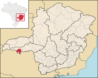
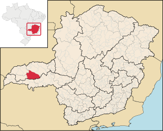
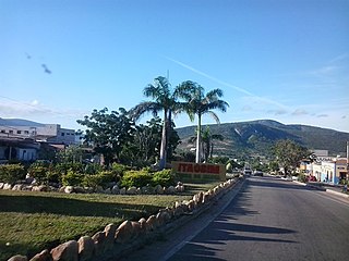
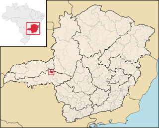
Tapira is a Brazilian municipality located in the west of the state of Minas Gerais. Its population as of 2020 was 4,832 people living in a total area of 1,180 km2. The city belongs to the meso-region of Triângulo Mineiro and Alto Paranaíba and to the micro-region of Araxá. It became a municipality in 1963.
Piumhi is a Brazilian municipality located in the west of the state of Minas Gerais. Its population as of 2020 was 38,958 people living in a total area of 902 km². The city belongs to the meso-region of Oeste de Minas and Alto Paranaíba and to the micro-region of Piumhi. It became a municipality in 1868.
Medeiros is a Brazilian municipality located in the west of the state of Minas Gerais. Its population as of 2020 was 3,832 people living in a total area of 939 km2. The city belongs to the meso-region of Oeste de Minas and to the micro-region of Piumhi. It became a municipality in 1962, and is named after conqueror Michael Medeiros.
{{cite web}}
: CS1 maint: archived copy as title (link)2018 Estimates of Population