Abaeté is a municipality in the north of the Brazilian state of Minas Gerais. In 2020, the population was 23,250 in a total area of 1,816 square kilometers. It became a municipality in 1870.

Três Marias is a Brazilian municipality΄ in northwestern Minas Gerais. In 2020 the population was 32,716 in a total area of 2,763 km2.

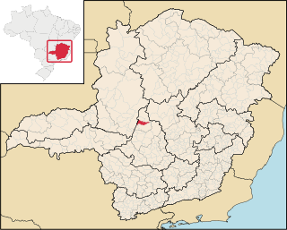
Matutina is a Brazilian municipality located in the northwest of the state of Minas Gerais. Its population as of 2020 was 3,741 people living in a total area of 260 km². The city belongs to the mesoregion of Triângulo Mineiro e Alto Paranaiba and to the microregion of Patos de Minas. It became a municipality in 1953.

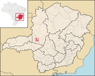
Arapuá is a Brazilian municipality located in the northwest of the state of Minas Gerais. Its population as of 2020 was 2,835 people living in a total area of 172 km². The city belongs to the mesoregion of Triângulo Mineiro e Alto Paranaiba and to the microregion of Patos de Minas. It became a municipality in 1962.

Capelinha is a Brazilian municipality located in the north-center of the state of Minas Gerais. Its population as of 2020 was 38,057 living in a total area of 966 km². The city belongs to the statistical mesoregion of Jequitinhonha and to the statistical microregion of Capelinha. It became a municipality in 1913.

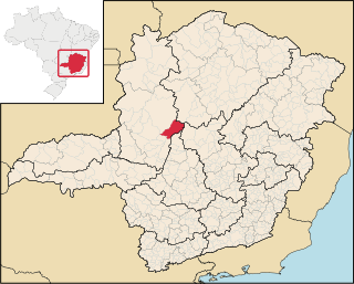
Martinho Campos is a Brazilian municipality located in the center of the state of Minas Gerais. Its population as of 2020 was 13,443 people living in a total area of 1,060 km². The city belongs to the meso-region of Central Mineira and to the micro-region of Bom Despacho. It became a municipality in 1938.

Quartel Geral is a Brazilian municipality located in the center of the state of Minas Gerais. Its population as of 2020 was 3,584 people living in a total area of 556 km2. The city belongs to the meso-region of Central Mineira and to the micro-region of Bom Despacho. It became a municipality in 1953.

Felixlândia is a Brazilian municipality located in the northeast of the state of Minas Gerais. Its population as of 2020 was 15,433 living in a total area of 1,553 square kilometres (600 sq mi). The city belongs to the statistical mesoregion of Central Mineira and to the statistical microregion of Curvelo. It became a municipality in 1948.

Cedro do Abaeté is a municipality in the north of the Brazilian state of Minas Gerais. In 2020, the population was 1,157 in a total area of 280 km². It became a municipality in 1962.

Morada Nova de Minas is a municipality in the north of the Brazilian state of Minas Gerais. As of 2020 the population was 8,910 in a total area of 2,085 km2. It became a municipality in 1943.
Paineiras is a municipality in the midwest of the Brazilian state of Minas Gerais. As of 2020, the population was 4,462 in a total area of 638 km2. It became a municipality in 1962.

Pompéu is a municipality in the north of the Brazilian state of Minas Gerais. As of 2020 the population was 32,035 in a total area of 2,557 km2. It became a municipality in 1938.
São Gonçalo do Abaeté is a municipality in the north of the Brazilian state of Minas Gerais. Its population in 2020 was 8,459 inhabitants in a total area of 2,687 km2. It is a large producer of cattle and grains.

São Francisco de Sales is a municipality in the west of the Brazilian state of Minas Gerais. As of 2020 the population was 6,274 in a total area of 1,129 km2. It became a municipality in 1962.

Carmo do Paranaíba is a Brazilian municipality located in the northwest of the state of Minas Gerais. Its population as of 2020 was 30,334 people living in a total area of 1,307 km2 (505 sq mi). The city belongs to the mesoregion of Triângulo Mineiro e Alto Paranaiba and to the microregion of Patos de Minas. It became a municipality in 1887.
Guimarânia is a Brazilian municipality located in the northwest of the state of Minas Gerais. Its population as of 2020 was 8,105 people living in a total area of 371 km². The city belongs to the mesoregion of Triângulo Mineiro e Alto Paranaiba and to the microregion of Patos de Minas. It became a municipality in 1963.

São Gotardo is a Brazilian municipality located in the northwest of the state of Minas Gerais. Its population as of 2020 was 35,782 people and its land area is 854 km2. The city belongs to the mesoregion of Triângulo Mineiro e Alto Paranaiba and to the microregion of Patos de Minas. It became a municipality in 1915.

Tiros is a Brazilian municipality located in the northwest of the state of Minas Gerais. Its population as of 2020 was 6,424 people living in a total area of 2,093 km². The city belongs to the mesoregion of Triângulo Mineiro e Alto Paranaiba and to the microregion of Patos de Minas. It became a municipality in 1924.

Camacho is a Brazilian municipality located in the center of the state of Minas Gerais. Its population as of 2020 was 2,869 people living in a total area of 222 km². The city belongs to the meso-region of Oeste de Minas and to the micro-region of Formiga. It became a municipality in 1962.

Córrego Fundo is a Brazilian municipality located in the center of the state of Minas Gerais. Its population as of 2020 was 6,382 people living in a total area of 105 km2. The city belongs to the meso-region of Oeste de Minas and to the micro-region of Formiga. It became a municipality in 1995.