Itabira

Last updated
Itabira
Municipality of Itabira
Carlos Drummond de Andrade, Itabira.jpg
Itabira MG Brasil - Vista aerea - panoramio (1).jpg
Expedicao Serra dos Alves - Agosto 2013 - panoramio.jpg
Expedicao Serra dos Alves - Agosto 2013 - panoramio (3).jpg
Memorial Drummond.JPG
Expedicao Serra dos Alves - Morro Redondo 2013 - panoramio.jpg
Bandeira de Itabira.jpg
Mini Itabira brasao.gif
Nickname(s): 

Cidade do Ferro ("City of Iron") [1] [2]
Cidade da Poesia ("City of Poetry") [3]
Capital Nacional da Poesia ("National Capital of Poetry") [4]
Capital Estadual do Tropeirismo ("State Capital of Tropeirismo") [5]
Ita City
MinasGerais Municip Itabira.svg
Location in Minas Gerais
Brazil location map.svg
Red pog.svg
Itabira
Location in Brazil
Coordinates: 19°37′08″S43°13′37″W / 19.61889°S 43.22694°W / -19.61889; -43.22694
Country Flag of Brazil.svg  Brazil
State Bandeira de Minas Gerais.svg  Minas Gerais
Region Southeast
Intermediate Region Belo Horizonte
Immediate Region Itabira
Government
   Mayor Marco Antônio Lage (PSB)
Area
  Total1,253.704 km2 (484.058 sq mi)
Elevation
795 m (2,608 ft)
Population
 (2020 est.) [6]
  Total120,904
  Density96/km2 (250/sq mi)
Demonym itabirano
Time zone UTC−3 (BRT)
HDI (2010)0.756 – high [7]
Website itabira.mg.gov.br
Banded Iron Formation or "itabirite", polished slab from the Paleoproterozoic-aged Minas Supergroup in the Iron Quadrangle District. The red bands are hematite, and the silver bands are magnetite. These are quarried, sawn, polished and sold as decorative stones. BIF (jaspilite meta-BIF, Paleoproterozoic Minas Gerais.jpg
Banded Iron Formation or "itabirite", polished slab from the Paleoproterozoic-aged Minas Supergroup in the Iron Quadrangle District. The red bands are hematite, and the silver bands are magnetite. These are quarried, sawn, polished and sold as decorative stones.

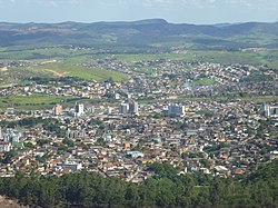
Itabira is a Brazilian municipality and a major city in the state of Minas Gerais. The city belongs to the Belo Horizonte metropolitan area mesoregion and to the Itabira microregion.

Contents

It is currently the twenty-fourth largest city in the state in terms of population, with 120,904 inhabitants, according to a 2020 IBGE survey. It is known as the "Capital of Poetry", by virtue of being the birthplace of poet Carlos Drummond de Andrade, is part of the Circuit of the Gold and of Estrada Real.

History

The first settlements at the site date to the early eighteenth century, when the village of Itabira do Mato Dentro was founded by bandeirantes seeking gold. Itabira was politically emancipated as a municipality on 9 October 1848, through Provincial Law No. 374.[ citation needed ]

Geography

It is located in southeast Minas Gerais, 110 kilometers away from the state capital, Belo Horizonte and 845 kilometers away from the federal capital Brasília. The highest point in the city is 1,672 meters above sea level, and is known as Alto da Mutuca. Itabira is an access point for a number of smaller cities, such as Jaboticatubas, Santa Maria de Itabira, Itambé do Mato Dentro and Nova Era. The closest international airport is Tancredo Neves International Airport (Confins) in Belo Horizonte.

Itabira is a regional economic center, and hosts a thriving iron ore extraction operation headed by Companhia Vale do Rio Doce since 1942, when the company was created by President Getúlio Vargas specifically for the mineral exploration of the Rio Doce valley. As of 2017, it is the second largest mining company in the world, and a considerable part of its iron ore output comes from the mines at Itabira.[ citation needed ] As a result of the decades-old extraction operations, the city faces air pollution problems. [ citation needed ]

Culture

In Carlos Drummond de Andrade's poem "Confidência do Itabirano," the speaker remarks: [8]

"Tive ouro, tive gado, tive fazendas.

Hoje sou funcionário público.

Itabira é apenas uma fotografia na parede.

Mas como dói!"

"I had gold, I had cattle, I had farms.

Today I'm a public servant.

Itabira is just a photograph on the wall.

But oh, how it hurts!"

Notable people

Sister cities - twin towns

Itabira has a one sister city:

Flag of Brazil.svg Itajubá, Minas Gerais, Brazil [9]

See also

Related Research Articles

<span class="mw-page-title-main">Belo Horizonte</span> Capital city of Minas Gerais, Brazil

Belo Horizonte is the sixth-largest city in Brazil, with a population of around 2.3 million, and the third largest metropolitan area, with a population of 6 million. It is the 13th-largest city in South America and the 18th-largest in the Americas. The metropolis is anchor to the Belo Horizonte metropolitan area, ranked as the third most populous metropolitan area in Brazil and the 17th most populous in the Americas. Belo Horizonte is the capital of the state of Minas Gerais, Brazil's second-most populous state. It is the first planned modern city in Brazil.

<span class="mw-page-title-main">Minas Gerais</span> State in Southeastern Brazil

Minas Gerais is one of the 27 federative units of Brazil, being the fourth largest state by area and the second largest in number of inhabitants with a population of 20,539,989 according to the 2022 census. Located in the Southeast Region of the country, it is limited to south and southwest with São Paulo; Mato Grosso do Sul to the west; Goiás and the Federal District to the northwest; Bahia to the north and northeast; Espírito Santo to the east; and Rio de Janeiro to the southeast. The state's capital and largest city, Belo Horizonte, is a major urban and finance center in Brazil, being the sixth most populous municipality in the country while its metropolitan area ranks as the third largest in Brazil with just over 5.8 million inhabitants, after those of São Paulo and Rio de Janeiro. Minas Gerais' territory is subdivided into 853 municipalities, the largest number among Brazilian states.

<span class="mw-page-title-main">Salinas, Minas Gerais</span> Salinas is a municipality in Minas Gerais, Brazil

Salinas is a municipality in the northeast of the Brazilian state of Minas Gerais.

<span class="mw-page-title-main">Carlos Drummond de Andrade Airport</span> Airport in Minas Gerais, Brazil

Pampulha–Carlos Drummond de Andrade Airport is an airport serving Belo Horizonte, Brazil, located in the neighborhood of Pampulha. Since December 16, 2004, the airport is also named after the Minas Gerais-born poet Carlos Drummond de Andrade (1902–1987).

<span class="mw-page-title-main">Itajubá</span> Municipality in Southeast, Brazil

Itajubá is a municipality in southeastern Minas Gerais state of the Federative Republic of Brazil. It lies in a valley by the Sapucaí river and has terrain elevations ranging from 827 to 1500 metres, occupying an area of 290.45 km2 (112.14 mi2), with a population of 97,334 people. Neighboring the city are the mountain slopes of the Serra da Mantiqueira range. The climate sees heavy rain in the summer months with dry weather in the winter.

<span class="mw-page-title-main">Santa Bárbara, Minas Gerais</span> Municipality in Southeast, Brazil

Santa Bárbara is a Brazilian municipality founded in 1704 and located in the state of Minas Gerais. It is a historic town on the Gold Circuit of Minas Gerais, located ninety-eight kilometres from Belo Horizonte, in the centre of the Estrada Real. The bucolic landscape, with its churches, roofs and backyards at the foot of the imposing Serra do Caraça makes Santa Bárbara one of the most beautiful towns in Minas Gerais. Despite the current increase in economic development, it is a peaceful and welcoming town with simple and hospitable people who preserve their traditions and live an active cultural life. The 6th President of Brazil, Afonso Pena was born in Santa Bárbara.

<span class="mw-page-title-main">Nova Lima</span> Municipality in Minas Gerais, Brazil

Nova Lima is a municipality of about 87,000 people, whose downtown is located about 20 kilometers south of Belo Horizonte, the capital of the south-eastern Brazilian state of Minas Gerais. Mining is one of the main economical activities of the city, including the extraction of Iron Ore and Gold. The most famous mine in the city is Morro Velho, a gold mine of 2,700 metres (8,900 ft) depth.

<span class="mw-page-title-main">Oliveira, Minas Gerais</span> Municipality in Southeast, Brazil

Oliveira is a Brazilian municipality in the state of Minas Gerais. It is located at latitude 20º41'47" south and longitude 44º49'38" west, at an altitude of 982 metres. It is located 165 kilometres at southwest from Belo Horizonte. Its estimated population was 41,181 according to the latest IBGE census.

<span class="mw-page-title-main">Conceição do Mato Dentro</span> Place in Southeast, Brazil

Conceição do Mato Dentro is a Brazilian municipality located in the state of Minas Gerais. The city belongs to the mesoregion Metropolitana de Belo Horizonte and to the microregion of Conceição do Mato Dentro.

<span class="mw-page-title-main">Congonhas do Norte</span> Municipality in Minas Gerais, Brazil

Congonhas do Norte is a Brazilian municipality located in the state of Minas Gerais. The city belongs to the mesoregion Metropolitana de Belo Horizonte and to the microregion of Conceição do Mato Dentro.

<span class="mw-page-title-main">Itambé do Mato Dentro</span> Municipality of Brazil

Itambé do Mato Dentro is a Brazilian municipality located in the state of Minas Gerais. The city belongs to the mesoregion Metropolitana de Belo Horizonte and to the microregion of Conceição do Mato Dentro. As of 2020, the estimated population was 2,056.

<span class="mw-page-title-main">Rio Vermelho</span> Municipality in Minas Gerais, Brazil

Rio Vermelho is a Brazilian municipality located in the state of Minas Gerais. The city belongs to the mesoregion Metropolitana de Belo Horizonte and to the microregion of Conceição do Mato Dentro. As of 2020, the estimated population was 12,739.

<span class="mw-page-title-main">Santo Antônio do Rio Abaixo</span> Human settlement in Brazil

Santo Antônio do Rio Abaixo is a Brazilian municipality located in the state of Minas Gerais. The city belongs to the mesoregion of Belo Horizonte and to the microregion of Conceição do Mato Dentro. The estimated population in 2020 was 1,760 inhabitants.

<span class="mw-page-title-main">Serra Azul de Minas</span> Brazilian municipality

Serra Azul de Minas is a Brazilian municipality located in the state of Minas Gerais. The city belongs to the mesoregion Metropolitana de Belo Horizonte and to the microregion of Conceição do Mato Dentro. As of 2020, the estimated population was 4,292.

<span class="mw-page-title-main">Serro</span> Municipality in Southeast, Brazil

Serro is a Brazilian municipality located in the state of Minas Gerais. The city belongs to the metropolitan area of Belo Horizonte and to the microregion of Conceição do Mato Dentro. As of 2020, the estimated population was 20,940.

<span class="mw-page-title-main">Roman Catholic Archdiocese of Mariana</span> Catholic ecclesiastical territory

The Roman Catholic Archdiocese of Mariana is an archdiocese based in the city of Mariana in the Brazilian state of Minas Gerais.

<span class="mw-page-title-main">Nova União, Minas Gerais</span> Municipality of Minas Gerais, Brazil

Nova União is a municipality located in the Brazilian state of Minas Gerais. The city belongs to the mesoregion Metropolitana de Belo Horizonte and to the microregion of Itabira. As of 2020, the estimated population was 5,732.

<span class="mw-page-title-main">Dionísio, Minas Gerais</span> Municipality in Minas Gerais, Brazil

Dionísio is a municipality in the state of Minas Gerais, Brazil. The city belongs to the mesoregion Metropolitana de Belo Horizonte and to the microregion of Itabira. As of 2020, the estimated population was 7,609.

Voe Minas Gerais was a program and informal name of a domestic airline based in Belo Horizonte/Pampulha – Carlos Drummond de Andrade Airport, Brazil, established in 2016 by the Government of the State of Minas Gerais via its Minas Gerais Development Company CODEMGE.

<span class="mw-page-title-main">Immediate Geographic Region of Itabira</span> Urban administrative region in Minas Gerais, Brazil

The Immediate Geographic Region of Itabira is one of the 10 immediate geographic regions in the Intermediate Geographic Region of Belo Horizonte, which is one of the 70 immediate geographic regions in the Brazilian state of Minas Gerais and one of the 509 of Brazil. This classification was created by the National Institute of Geography and Statistics (IBGE) in 2017.

References

  1. "Creative Economy and Culture in Itabira, the City of Iron and Poetry". UNESCO (in Brazilian Portuguese). Retrieved 2023-05-23.
  2. "ANIVERSÁRIO DE ITABIRA". Associação dos Municípios Mineradores de Minas Gerais (AMIG) (in Brazilian Portuguese). Retrieved 2023-05-23.
  3. "Na "Cidade da Poesia", Festival Literário de Itabira homenageia Drummond pelos seus 120 anos". Midia Ninja (in Brazilian Portuguese). 2022-11-01. Retrieved 2023-05-23.
  4. "Santa Maria de Itabira – Casa de D. Maria Prachedes". ipatrimônio (in Brazilian Portuguese). Retrieved 2023-05-23.
  5. "Itabira – Muito além de Carlos Drummond de Andrade". 98FM (in Brazilian Portuguese). 2022-05-12. Retrieved 2023-05-23.
  6. IBGE 2020
  7. "IDHM 2010" (PDF). United Nations Development Programme (UNDP). Archived from the original (PDF) on July 8, 2014. Retrieved August 1, 2013.
  8. "Confidência do Itabirano - Carlos Drummond de Andrade". Letras.mus.br (in Brazilian Portuguese). Retrieved 2020-02-29.
  9. DeFato Online: Itabira é declarada cidade-irmã de Itajubá; o foco é o crescimento da Unifei