Camanducaia | |
|---|---|
| Municipality of Camanducaia | |
 Flag  Seal | |
| Nicknames: Campos Queimados | |
 Location in Minas Gerais | |
| Coordinates: 14°25′03″S44°22′13″W / 14.41750°S 44.37028°W | |
| Country | |
| Region | Southeast |
| State | |
| Founded | July 20, 1868 |
| Government | |
| • Mayor | Edmar Cassalho Moreira Dias (PMDB) |
| Area | |
• Total | 527.572 km2 (203.697 sq mi) |
| Elevation | 1,015 m (3,330 ft) |
| Population (2020 [1] ) | |
• Total | 21,801 |
| • Density | 40/km2 (100/sq mi) |
| Time zone | UTC-3 (UTC-3) |
| • Summer (DST) | UTC-2 (UTC-2) |
| HDI (2010) | 0.689 – medium [2] |


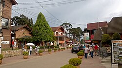


Camanducaia is the southernmost municipality in Minas Gerais, Brazil. The population was 21,801 in 2020.
The municipality contains part of the 180,373-hectare (445,710-acre) Fernão Dias Environmental Protection Area, created in 1997. [3]
