Lagoa da Prata

Last updated
Lagoa da Prata
Lagoa da Prata Centro.jpg
Bandeira de Lagoa.png
Brasao de Lagoa.png
Motto(s): 
Work, progress, faith ("Trabalho, progresso, fé" in portuguese)
MinasGerais Municip LagoadaPrata.svg
Brazil location map.svg
Red pog.svg
Lagoa da Prata
Coordinates: 20°01′22″S45°32′38″W / 20.02278°S 45.54389°W / -20.02278; -45.54389
Country Flag of Brazil.svg  Brazil
Region Southeast
State Bandeira de Minas Gerais.svg  Minas Gerais
Municipal incorporation December 27, 1938
Government
   Mayor Di Gianne de Oliveira Nunes (Cidadania)
Area
  Total439.984 km2 (169.879 sq mi)
Population
 (2020 [1] )
  Total52,711
  Density118.5/km2 (307/sq mi)
Time zone UTC−3 (BRT)

Lagoa da Prata is a Brazilian municipality in the state of Minas Gerais. In 2020, its population was estimated to be 52,711. The city belongs to the mesoregion of Central Mineira and to the microregion of Bom Despacho.

Contents

Early history

In the 18th century, when Tiradentes was dismembered, the municipality of Itapecerica was created, consisting of 34 districts (or divisions) called ordinanças do Reino. Among them, there was a part called Pântano (where the municipality of Lagoa da Prata is located today), the 12th located. Another was Santo Antônio do Monte.

The occupation of the place where the city is today began with a dam, built by a Portuguese named Novato, who wanted mills and monjolos. With the expansion of its embankment and the affluence of the adjacent swamp, the small dam was transformed into a lagoon. Around 1850, Lieutenant Francisco Bernardes acquired a large extension of land on the banks of the São Francisco River. Bernardes acquired a large tract of land on the banks of the São Francisco River and established himself commercially there, later dedicating himself to agriculture. When he died, the farm was acquired by his nephew Colonel Carlos José Bernardes Sobrinho, who transferred it to the vicinity of the aforementioned lake, dedicating himself to the commercialization of coffee and oxen.

In a short time, there were a large number of inhabitants among households, family members and employees. Later, Colonel Carlos Bernardes donated land for the construction of the Church under the patronage of São Carlos, around which the village developed. One day, some missionary friars, passing by the shores of the lake, observed reflections of the sun on the waters. They referred to the place as “Lagoa da Prata”. An excerpt from the book: História de Lagoa da Prata, by Acácio Mendes, tells the story of the origin of the name of what would then be the municipality:

“One day some Franciscan Friars who were preaching Missions came to the edge of this dam and who, naturally to have a snack and rest for a few hours, on a calm day, the sun at its height and when the waters of the dam, serene and gentle, they were shaken by the breath of the breeze that calmly made a reflection on the surface of the water. On that occasion the rays of the sun in those ebbs gave the impression of silver coins falling on the waters; and then from that comment was the memory of silver falling into the pond. And right at the first landing, as in the others, whenever the friars wanted to refer to that lake where they had rested and which still had no name, they would say: – 'In the silver lake', and the friars by "silver lake" and the aka was then replacing the plural by the simplest: Lagoa da Prata. So, when Carlos Bernardes, in 1875, built his mansion in its surroundings, he already found Lagoa da Prata named”.

Carlos Bernardes died suddenly in 1900. At the 1st Mass in the chapel still under construction, Monsignor Otaviano José de Araújo, vicar of Santo Antônio do Monte gave the chapel the name of São Carlos and called on the people to change the name of the place, which is renamed São Carlos do Pântano. However, in 1916, even with the name change, in the creation of the railway and stop that passed through the region, the residents baptized the new station with the name of the lagoon, thus inaugurating the Lagoa da Prata Station. The village was subordinated to the municipality of Santo Antônio do Monte for a while, separating from it over the decades.

In 1923 the District of Lagoa da Prata was created, and in 1938 came its separation and emancipation, becoming the Municipality of Lagoa da Prata. The flat topography and the fertility of the land attracted migrants and companies. The municipality became a major producer of cereals, sugar cane and had a significant bovine herd. With the establishment of the sugar industry and candies and caramels, a new influx of people was created.

Modern day

The downtown region of Lagoa da Prata is situated on hilly terrain, and at the end of the high road is a church which overlooks the city. Usina Luciânia was a residential neighbourhood situated approximately 6 km away from downtown, but nowadays it is an industrial site owned by Louis Dreyfus Group.

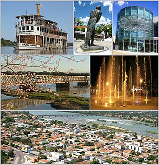
In 1968, a series of beaches were constructed on the border of the lagoon to attract tourists. Today, the beaches remain Lagoa da Prata's main tourist attraction. [2] Other tourist attractions include the Lagô Pirô, Ponte de Ferro ("Bridge of Iron" in English) which is a bridge that crosses the São Francisco River, a cachoeira da Cemiguinha ("The Cemiguinha Waterfall" in English) and a series of painted caves and grottos.

The bus station ("Rodoviária") is called Terminal Rodoviária Pedro Roberto Amorim after the mayor who commissioned its construction.

Geography

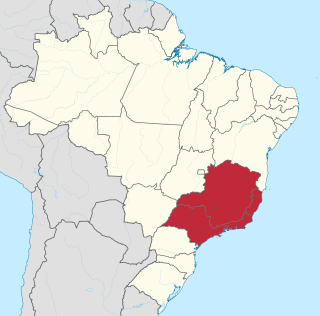
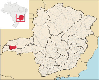
Lagoa da Prata is located in the Midwest of Minas Gerais, in Alto São Francisco, with an area of 439,984 km², 211 km from Belo Horizonte, the state capital.

The municipality of Lagoa da Prata is located at 658 meters of altitude and its predominant climate is the Tropical Altitude. The annual average temperature is 21.8 °C, and in summer it can pass around 30 °C and in winter it can reach less than 10 °C.

The city have two well-defined seasons: a hot and rainy summer between the months of October and March, and a cold and dry winter between May and September. The average annual precipitation is 1512mm.

The predominant natural vegetation cover is the Cerrado and its variants, but today only small remnants of the natural vegetation are intact, due to the intense deforestation for cultivation of pastures and agricultural activities such as the cultivation of sugar cane.

Demographics

According to the IBGE, 52,165 people lived in the municipality of Lagoa da Prata in 2019, 97.7% of whom lived in the urban area and only 2.3% in the rural area.

Ethnicities and migration

Lagoa da Prata is a multiracial city, result of migration. As well as the population of Minas Gerais in general, the Lagopratense population was formed by a great diversity of peoples, including amerindians, portugueses and africans.

In the 2010 IBGE Census, in a self-declaration survey, of the 45,984 inhabitants of the city, there were 25,903 Whites (56.33%), 16.221 Pardos (35.28%), 3,776 Blacks (8.21%) and 83 Asians (0.18%).

It is also remarkable the presence of descendants of European peoples who have recently migrated to the city, most of whom are Italian and to a lesser extent, German, Dutch, Spanish, Russian and French. Descendants of Asian peoples are also present, mainly of Japanese, Chinese and Lebanese origins.

Religion

According to data from the Brazilian Institute of Geography and Statistics (IBGE), in 2010 the population of Lagoa da Prata was 37,627 Roman Catholics (81.83%), 7.165 Protestants (15.58%), 330 Jehovah's Witnesses ( 0.72%), 237 Spiritists (0.52%), 47 Indigenous Traditions (0.1%) and 1.258 no-religious (2.73%).

Economy

Three large industries are installed in the city, which heat up the local economy and employ a large part of the population: Embaré (food industry); Biosev (agricultural industry) and Pharlab (pharmaceutical industry). In addition to these, trade is very important for the local economy, especially that related to the bicycle and motorcycle industry, such as LM Motos, LM Bike, Athor Bike, Total Maxparts and Gominha Pneus.

Etymology

In English, "Lagoa da Prata" means "Silver Lagoon", the name of the lagoon which the city is named after. It is called Silver Lagoon due to the silver sheen the clean water reflects when the sun shines on it. Its striking colour has led to priests and missionaries visiting the city.

Personalities born in Lagoa da Prata

Famous people

Related Research Articles

<span class="mw-page-title-main">Minas Gerais</span> State in Southeastern Brazil

Minas Gerais is one of the 27 federative units of Brazil, being the fourth largest state by area and the second largest in number of inhabitants with a population of 20,539,989 according to the 2022 census. Located in the Southeast Region of the country, it is limited to south and southwest with São Paulo; Mato Grosso do Sul to the west; Goiás and the Federal District to the northwest; Bahia to the north and northeast; Espírito Santo to the east; and Rio de Janeiro to the southeast. The state's capital and largest city, Belo Horizonte, is a major urban and finance center in Brazil, being the sixth most populous municipality in the country while its metropolitan area ranks as the third largest in Brazil with just over 5.8 million inhabitants, after those of São Paulo and Rio de Janeiro. Minas Gerais' territory is subdivided into 853 municipalities, the largest number among Brazilian states.

<span class="mw-page-title-main">Montes Claros</span> Municipality in Southeast, Brazil

Montes Claros is a city located in northern Minas Gerais state, in Brazil. It is located north of the state capital, about 422 km away from it. The population is 413,487 in an area of 3,569 km2 (1,378 sq mi). It was made a seat of a municipality in 1831 and attained city status in 1857.

<span class="mw-page-title-main">Pirapora</span> Municipality in Southeast, Brazil

Pirapora is a municipality in northcentral Minas Gerais in Brazil. The population is 56,640 in an area of 550 km². The name Pirapora comes from the Tupi words for "fish" + "jump", referring to the piracema season when a mass migration of fishes ascends the São Francisco River to spawn.

<span class="mw-page-title-main">Luz, Minas Gerais</span> Municipality in Southeast, Brazil

Luz is a Brazilian municipality located in the West part of the state of Minas Gerais. Luz is located between the city of Araxá and the capital city of the state of Minas Gerais, Belo Horizonte. The population is 18,257 in an area of 1172 km². The city belongs to the Central Mineira region and to the micro-region of Bom Despacho. It became a municipality in 1923.

<span class="mw-page-title-main">Sete Lagoas</span> Municipality in Southeast, Brazil

Sete Lagoas is a city in the Brazilian state of Minas Gerais. The municipal area is 537;km² while the population was 241,835 in 2020.

<span class="mw-page-title-main">Southeast Region, Brazil</span> Region in Brazil

The Southeast Region of Brazil is composed of the states of Espírito Santo, Minas Gerais, Rio de Janeiro and São Paulo. It is the richest region of the country, responsible for approximately 60% of the Brazilian GDP, as São Paulo, Rio de Janeiro, and Minas Gerais are the three richest states of Brazil, the top three Brazilian states in terms of GDP. The Southeast of Brazil also has the highest GDP per capita among all Brazilian regions.

<span class="mw-page-title-main">Viçosa, Minas Gerais</span> Municipality in Southeast, Brazil

Viçosa is a Brazilian municipality in the state of Minas Gerais. Its population as of 2021 was estimated at 79,910 inhabitants.

Lagoa may refer to the following:

<span class="mw-page-title-main">Lavras</span> Municipality in Southeast, Brazil

Lavras is a municipality in southern Minas Gerais state, Brazil. Located at an altitude of 919 m, it has a population of 104,761 inhabitants (2022). The area of the municipality is 564.495 km2. The average annual temperature is 19.6°C and the average annual rainfall is 1,511 millimetres.

<span class="mw-page-title-main">Santo Antônio do Monte</span> Municipality in Southeast, Brazil

Santo Antônio do Monte is a municipality in the central part of the state of Minas Gerais, Brazil. The population is 28,427 in an area of 1125.78 km². The city is located 194 km west of state capital Belo Horizonte. The city is also known as Samonte. Santo Antonio do Monte was founded in the 18th century and it became a municipality on November 16, 1875. The main economic activity of the city is the production of fireworks. Nowadays there are in the city about 70 firework factories.

<span class="mw-page-title-main">Bom Despacho, Minas Gerais</span> Municipality in Southeast, Brazil

Bom Despacho is a Brazilian municipality located in the west of the state of Minas Gerais. The population is 51,028 in an area of 1213.55 km². The city belongs to the meso-region of Central Mineira and to the micro-region of Bom Despacho. It became a municipality in 1912.

<span class="mw-page-title-main">Oliveira, Minas Gerais</span> Municipality in Southeast, Brazil

Oliveira is a Brazilian municipality in the state of Minas Gerais. It is located at latitude 20º41'47" south and longitude 44º49'38" west, at an altitude of 982 metres. It is located 165 kilometres at southwest from Belo Horizonte. Its estimated population was 41,181 according to the latest IBGE census.

<span class="mw-page-title-main">Japaraíba</span> Town and municipality in the state of Minas Gerais, Brazil

Japaraíba is a Brazilian municipality located in the center of the state of Minas Gerais. Its population as of 2020 was 4,384 people living in a total area of 172 km². The city belongs to the meso-region of Central Mineira and to the micro-region of Bom Despacho. It became a municipality in 1962.

<span class="mw-page-title-main">Moema, Minas Gerais</span> Brazilian municipality

Moema is a Brazilian municipality located in the center of the state of Minas Gerais. Its population as of 2020 was 7,554 people living in a total area of 203 km². The city belongs to the meso-region of Central Mineira and to the micro-region of Bom Despacho. It became a municipality in 1953.

<span class="mw-page-title-main">Raul Soares</span> Municipality in Minas Gerais, Brazil

Raul Soares is a Brazilian municipality located in the state of Minas Gerais. The city belongs to the mesoregion of Zona da Mata and extends to the microregion of Ponte Nova. As of 2020, the estimated population was 23,711.

<span class="mw-page-title-main">Coração de Jesus</span> Municipality in Minas Gerais, Brazil

Coração de Jesus is a Brazilian municipality located in the north of the state of Minas Gerais. In 2020 the population was 26,611 in a total area of 2,236 km². It became a municipality in 1912.

<span class="mw-page-title-main">Campina Verde</span> Municipality in the north of the Brazilian state of Minas Gerais

Campina Verde is a municipality in the north of the Brazilian state of Minas Gerais. As of 2020 the population was 19,752 in a total area of 3,663 km². It became a municipality in 1938.

<span class="mw-page-title-main">Iguatama</span> Brazilian municipality

Iguatama is a Brazilian municipality located in the west of the state of Minas Gerais. Its population as of 2020 was 7,923 people living in a total area of 627 km². The city belongs to the meso-region of Oeste de Minas and to the micro-region of Piumhi. It became a municipality in 1944.

<span class="mw-page-title-main">Immediate Geographic Region of Divinópolis</span> Urban administrative region in Minas Gerais, Brazil

The Immediate Geographic Region of Divinópolis is one of the 6 immediate geographic regions in the Intermediate Geographic Region of Divinópolis, one of the 70 immediate geographic regions in the Brazilian state of Minas Gerais and one of the 509 of Brazil, created by the National Institute of Geography and Statistics (IBGE) in 2017.

<span class="mw-page-title-main">Immediate Geographic Region of Montes Claros</span> Urban administrative region in Minas Gerais, Brazil

The Immediate Geographic Region of Montes Claros is one of the 7 immediate geographic regions in the Intermediate Geographic Region of Montes Claros, one of the 70 immediate geographic regions in the Brazilian state of Minas Gerais and one of the 509 of Brazil, created by the National Institute of Geography and Statistics (IBGE) in 2017.

References

  1. IBGE 2020
  2. History and Tourist Potential of Lagoa da Prata

20°01′S45°32′W / 20.017°S 45.533°W / -20.017; -45.533