
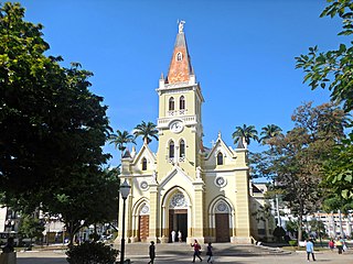
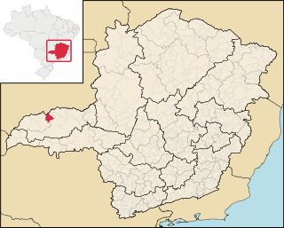
Ponte Nova is a municipality in central-eastern Minas Gerais state, Brazil.
Ponte Nova is a municipality in central-eastern Minas Gerais state, Brazil.
Ponte Nova is located a few kilometers south of the Doce River on a tributary called the Piranga. As of 2020, the population is estimated at 59,875 inhabitants and the area of the municipality is 470.6 km. [1] The elevation is 402 meters above sea level. It has railroad connections to Ouro Preto and is linked by state highways to the capital of Belo Horizonte and to Ouro Preto.
The beginnings of the city go back to 1755 when the first farms were established in the region. Agriculture and commerce were the occupations of the first inhabitants. The town saw the cycles of first sugar cane and then coffee. From 1770 to 1832, the town was officially denominated an Arraial and was called Capela Filial do Furquim. In 1862 it was raised to a Vila and Ponte Nova became the seat of a municipality in 1866. [2]
Distances to major cities:
The economy is based on agriculture, limited industry and services. Ponte Nova produces livestock, both dairy and meat, sugarcane, fruits and vegetables, and swine raising, this being quite developed with more than 350 establishments and 30,000 head.
Until recently the city was the center of a prosperous sugar-cane growing area and there were several mills (engenhos in Portuguese). The first sugar cane mill in the state of Minas Gerais was installed in Ponte Nova in 1885. Most of these have now closed.
The municipality included the 377 hectares (930 acres) Fazenda São Mateus Biological Reserve, created in 1974. [3] An audit in 2012 stated that a number of biological reserves created in 1974 on state-owned land were being re-assessed, since they no longer qualified as conservation units. These were Fazenda São Mateus, Carmo da Mata, Colônia 31 de Março and others. [4]

Belo Horizonte is the sixth-largest city in Brazil, with a population of around 2.3 million, and the third largest metropolitan area, containing a population of 6 million. It is the 13th-largest city in South America and the 18th-largest in the Americas. The metropolis is anchor to the Belo Horizonte metropolitan area, ranked as the third most populous metropolitan area in Brazil and the 17th most populous in the Americas. Belo Horizonte is the capital of the state of Minas Gerais, Brazil's second-most populous state. It is the first planned modern city in Brazil.

Minas Gerais is one of the 27 federative units of Brazil, being the fourth largest state by area and the second largest in number of inhabitants with a population of 20,539,989 according to the 2022 census. Located in the Southeast Region of the country, it is bordered to south and southwest by São Paulo; Mato Grosso do Sul to the west; Goiás and the Federal District to the northwest; Bahia to the north and northeast; Espírito Santo to the east; and Rio de Janeiro to the southeast. The state's capital and largest city, Belo Horizonte, is a major urban and finance center in Brazil, being the sixth most populous municipality in the country while its metropolitan area ranks as the third largest in Brazil with just over 5.8 million inhabitants, after those of São Paulo and Rio de Janeiro. Minas Gerais' territory is subdivided into 853 municipalities, the largest number among Brazilian states.

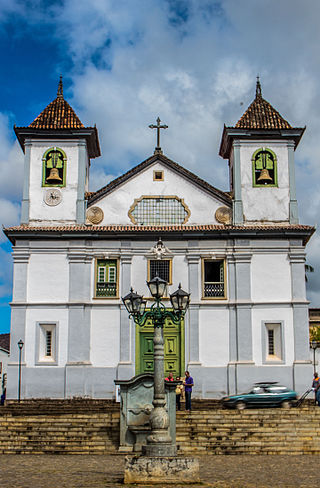
Ouro Preto, formerly Vila Rica, is a Brazilian municipality located in the state of Minas Gerais. The city, a former colonial mining town located in the Serra do Espinhaço mountains, was designated a World Heritage Site by UNESCO due to its Baroque colonial architecture. Ouro Preto used to be the capital of Minas Gerais from 1720 until the foundation of Belo Horizonte in 1897.

Juiz de Fora, also known as J.F., is a city in the southeastern Brazilian state of Minas Gerais, approximately 40 kilometres (25 mi) from the state border with Rio de Janeiro. According to the 2022 census the current population is 540,756 inhabitants. The geographical area of the municipality is 1,437 km2 (555 sq mi).

São João del-Rei is a Brazilian municipality in the state of Minas Gerais. Founded in 1713 in homage to king John V of Portugal, the city is famed for its historic Portuguese colonial architecture. The current population is estimated at 90,225 inhabitants.
Mineiro, Mineirês, or the Brazilian mountain accent is the Brazilian Portuguese term for the accent spoken in the Center, East and Southeast regions of the state of Minas Gerais.
Lúcia Machado de Almeida was a Brazilian writer. She was born in the Nova Granja farm, in São José da Lapa city, state of Minas Gerais. She moved to Belo Horizonte when she was a child. After that, she studied until High School at the Santa Maria school, in the same city. She learnt English, French, history of arts and music.
Caratinga is a municipality in eastern Minas Gerais state, Brazil. The population in 2020 was 92,603 inhabitants and the total area of the municipality was 1,251 km2. The elevation is 578 meters above sea level, with maximum elevation of 1,516 m in the Serra do Rio Preto and 330 m at the mouth of the Córrego Boachá.

Sacramento is a Brazilian municipality located in the west of the state of Minas Gerais. Its population as of 2020 was 26,374 people living in a total area of 3,071 km2. The city belongs to the meso-region of Triângulo Mineiro and Alto Paranaíba and to the micro-region of Araxá. It became a municipality in 1820.

Oliveira is a Brazilian municipality in the state of Minas Gerais. It is located at latitude 20º41'47" south and longitude 44º49'38" west, at an altitude of 982 metres. It is located 165 kilometres at southwest from Belo Horizonte. Its estimated population was 41,181 according to the latest IBGE census.

Felixlândia is a Brazilian municipality located in the northeast of the state of Minas Gerais. Its population as of 2020 was 15,433 living in a total area of 1,553 square kilometres (600 sq mi). The city belongs to the statistical mesoregion of Central Mineira and to the statistical microregion of Curvelo. It became a municipality in 1948.

Morada Nova de Minas is a municipality in the north of the Brazilian state of Minas Gerais. As of 2020 the population was 8,910 in a total area of 2,085 km2. It became a municipality in 1943.
The Roman Catholic Archdiocese of Mariana is an archdiocese based in the city of Mariana in the Brazilian state of Minas Gerais.
Canápolis is a Brazilian municipality located in the west of the state of Minas Gerais. Its population as of 2020 was 12,201 living in a total area of 845 km². The city belongs to the statistical mesoregion of Triângulo Mineiro and Alto Paranaíba and to the statistical microregion of Uberlândia. It became a municipality in 1948.

Minas Novas is a municipality in the northeast of the Brazilian state of Minas Gerais. In 2020, the population was 31,497 in a total area of 1,810 km². The elevation of the urban area is 635 meters. It is part of the IBGE statistical meso-region of Jequitinhonha and the micro-region of Capelinha. It became a municipality in 1730.
Colônia 31 de Março Biological Reserve was a biological reserve in Brazil.
Fazenda São Mateus Biological Reserve was a biological reserve in Minas Gerais, Brazil.

The Federal Institute of Minas Gerais, or in full: Federal Institute of Education, Science and Technology of Minas Gerais is a polytechnic university or community college located in the Brazilian cities of Belo Horizonte, Bambuí, Congonhas, Formiga, Governador Valadares, Ouro Preto, Ouro Branco, São João Evangelista and João Monlevade.

Greater Belo Horizonte, Brazil, is the name usually used to describe the Belo Horizonte metropolitan region, which is composed of 34 municipalities. As of 2013, it is the third largest metropolitan area of Brazil with more than Six million inhabitants; the largest city by population is Belo Horizonte.

Serra do Gandarela National Park is a national park in the state of Minas Gerais, Brazil. It protects a mountainous region holding a remnant of Atlantic Forest that is an important source of water for the city of Belo Horizonte.
20°24′57″S42°54′32″W / 20.4158333433°S 42.9088888989°W
| International | |
|---|---|
| National | |
