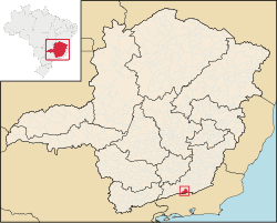
Belmiro Braga

Last updated
Location of Belmiro Braga within Minas Gerais MinasGerais Municip BelmiroBraga.svg
Location of Belmiro Braga within Minas Gerais

Belmiro Braga is a city in the state of Minas Gerais, Brazil close to the border with Rio de Janeiro state. It was emancipated from Juiz de Fora in 1962. As of 2020, the estimated population was 3,425 inhabitants. [1]

Contents

Geography

The municipality is located 295 km (by road) from the capital, Belo Horizonte.

Highways

Relief, climate, hydrography

The average annual temperature around 19 °C (66 °F), with a mean minimum of 14 °C (57 °F) and a mean maximum of 24 °C (75 °F). The municipality is in the basin of the Paraíba do Sul river.

Demographics

(Source: UNDP / 2000)

Related Research Articles

<span class="mw-page-title-main">Santos Dumont, Minas Gerais</span> Municipality in Southeast, Brazil

Santos Dumont is a municipality in southern Minas Gerais state, Brazil. The population (2020) is estimated to be 46,421 and the total area of the municipality is 639.1 km2 (246.8 sq mi). It lies at an elevation of 839 m (2,753 ft) just off the main interstate highway, BR040, between the urban centers of Barbacena (north) and Juiz de Fora (south). It is 240 km (150 mi) from the state capital, Belo Horizonte, and 220 km (140 mi) from Rio de Janeiro. It became a city in 1889.

<span class="mw-page-title-main">Bom Sucesso de Itararé</span> Place in São Paulo, Brazil

Bom Sucesso de Itararé is a municipality in the Brazilian state of São Paulo. Its population in 2020 was 3,984 and its area is 133.578 square kilometres (51.575 sq mi). It is located at an elevation of 950 metres (3,120 ft).

<span class="mw-page-title-main">Alfenas</span> City and municipality in the southern part of the Brazilian state of Minas Gerais

Alfenas is a municipality in the southern part of the Brazilian state of Minas Gerais. In 2020 its population was 80,494 and the area of the municipality is 849 km2. The elevation is 888m. It is served by highways MG 179, BR 491 and BR 369. The distance to the state capital of Belo Horizonte is 335 km and the distance to São Paulo is 300 km. The slogan for the city is "Alfenas, the gateway to the sea of Minas", in reference to nearby Lake Furnas.

<span class="mw-page-title-main">Virgem da Lapa</span> Municipality of Brazil

Virgem da Lapa is a Brazilian municipality located in the northeast of the state of Minas Gerais. Its population as of 2020 was estimated to be 13,740 people living in a total area of 871 km2 (336 sq mi). The city belongs to the mesoregion of Jequitinhonha and to the microregion of Araçuaí. It became a municipality in 1948.

<span class="mw-page-title-main">Bom Jardim de Minas</span> Municipality in Southeast, Brazil

Bom Jardim de Minas is a city of the state of Minas Gerais, Brazil.

<span class="mw-page-title-main">Caranavi Province</span> Province in La Paz Department, Bolivia

Caranavi Province is one of the twenty provinces of the Bolivian La Paz Department and is situated in the department's eastern parts. The province was created by Law 1401 on 16 December 1992 from a portion of what was then Nor Yungas Province. The creation of the province had been a local cause embraced by Ramiro Revuelta, a Deputy in the national legislature who was assassinated on November 28, 1992.

<span class="mw-page-title-main">Aporé</span> Place in Goiás, Brazil

Aporé is a municipality in southwest Goiás state, Brazil. The municipality is a large producer of cattle. Aporé belongs to the Southwest Goiás Microregion.

<span class="mw-page-title-main">Araçuaí</span> Place in Brazil

Araçuaí is a Brazilian municipality located in the northeast of the state of Minas Gerais in the Jequitinhonha River valley. The Araçuaí River, a tributary of the Jequitinhonha, flows through it. Its population as of 2020 was estimated to be 36,712 people living in a total area of 2,235 km2. The city belongs to the mesoregion of Jequitinhonha and the microregion of Araçuaí. The city is the seat of the Roman Catholic Diocese of Araçuaí. The elevation of the municipal seat is 307 meters. It became a municipality in 1870.

<span class="mw-page-title-main">Soto de Cerrato</span> Municipality in Castile and León, Spain

Soto de Cerrato is a municipality located in the province of Palencia, Castile and León, Spain. According to the 2004 census (INE), the municipality has a population of 212 inhabitants.

<span class="mw-page-title-main">Palmópolis</span> Municipality of Brazil

Palmópolis is a municipality in the northeast of the Brazilian state of Minas Gerais. Its population in 2020 was 5,349 inhabitants in a total area of 436 km².

<span class="mw-page-title-main">Janaúba</span> Town in Brazil

Janaúba is a municipality in the north of the Brazilian state of Minas Gerais. In 2020 the population was 72,018 in a total area of 2,189 km2. The elevation is 692 meters above sea level.

<span class="mw-page-title-main">São João das Missões</span> Human settlement in Brazil

São João das Missões is a municipality in the north of the Brazilian state of Minas Gerais. As of 2020 the population was 13,125 in a total area of 675 km². The elevation is 501 meters. It became a municipality in 1997.

<span class="mw-page-title-main">Porteirinha</span> Human settlement in Brazil

Porteirinha is a municipality in the northern region of Minas Gerais, Brazil. The population in 2020 was 37,864 in an area of 1,806 km². The elevation is 566 meters. It became a municipality in 1938. The postal code (CEP) is 39520-000.

<span class="mw-page-title-main">Itaobim</span> Municipality in Minas Gerais, Brazil

Itaobim is a municipality in the northeast of the Brazilian state of Minas Gerais. Its population in 2020 was 21,029 inhabitants in a total area of 680 km².

<span class="mw-page-title-main">Carlos Chagas, Minas Gerais</span> Brazilian municipality located in the northeast of the state of Minas Gerais

Carlos Chagas is a Brazilian municipality located in the northeast of the state of Minas Gerais. Its population as of 2020 was 18,674 living in a total area of 3,199 km2. The city belongs to the statistical mesoregion of Vale do Mucuri and to the statistical microregion of Nanuque. It became a municipality in 1938.

<span class="mw-page-title-main">Berilo</span> Municipality in Minas Gerais, Brazil

Berilo is a municipality in the northeast of the Brazilian state of Minas Gerais. As of 2020 the population was 11,872 in a total area of 586 km2. The elevation is 401 meters. It is part of the IBGE statistical meso-region of Jequitinhonha and the micro-region of Capelinha. It became a municipality in 1963.

<span class="mw-page-title-main">Chapada do Norte</span> Human settlement in Brazil

Chapada do Norte is a municipality in the northeast of the Brazilian state of Minas Gerais. As of 2020, the population was 15,345 in a total area of 828 km². The elevation of the town center is 751 meters. It is part of the IBGE statistical meso-region of Jequitinhonha and the micro-region of Capelinha. It became a municipality in 1963.

<span class="mw-page-title-main">Veríssimo</span> Town and municipality in the state of Minas Gerais, Brazil

Veríssimo is a Brazilian municipality located in the west of the state of Minas Gerais. Its population as of 2020 was estimated to be 4,045 people living in a total area of 1,028 km². The city belongs to the mesoregion of Triângulo Mineiro and Alto Paranaíba and to the micro-region of Uberaba. It became a municipality in 1938.

<span class="mw-page-title-main">Pains, Minas Gerais</span> Town and municipality in the state of Minas Gerais, Brazil

Pains is a Brazilian municipality located in the center of the state of Minas Gerais. Its population as of 2020 was 8,296 people living in a total area of 418 km². The city belongs to the meso-region of Oeste de Minas and to the micro-region of Formiga. It became a municipality in 1943.

<span class="mw-page-title-main">Pirapetinga</span> Municipality in Southeast, Brazil

Pirapetinga is a municipality in the state of Minas Gerais in the Southeast region of Brazil. Its estimated population in 2020 was 10,772 inhabitants (IBGE).

References

21°57′S43°25′W / 21.950°S 43.417°W / -21.950; -43.417