Pequi, Minas Gerais

Last updated
Pequi, Minas Gerais
Municipality
Closecidade.JPG
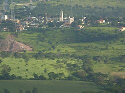
Partial view of Pequi
CountryFlag of Brazil.svg  Brazil
Region Southeast
State Minas Gerais
MesoregionMetropolitana de Belo Horizonte
Population
 (2020 [1] )
  Total4,432
Time zone UTC−3 (BRT)

Pequi, Minas Gerais is a municipality in the state of Minas Gerais in the Southeast region of Brazil. [2] [3] [4] [5]

See also

Related Research Articles

Rio Manso Municipality in Southeast, Brazil

Rio Manso is a municipality in the state of Minas Gerais in the Southeast region of Brazil.

São José da Varginha Municipality in Southeast, Brazil

São José da Varginha is a municipality in the state of Minas Gerais in the Southeast region of Brazil.

Cachoeira da Prata is a municipality in the state of Minas Gerais in the Southeast region of Brazil.

Fortuna de Minas is a municipality in the state of Minas Gerais in the Southeast region of Brazil.

Funilândia is a municipality in the state of Minas Gerais in the Southeast region of Brazil.

Prudente de Morais, Minas Gerais is a municipality in the state of Minas Gerais in the Southeast region of Brazil.

Santana do Riacho Municipality in Southeast, Brazil

Santana do Riacho is a municipality in the state of Minas Gerais in the Southeast region of Brazil.

Igaratinga is a municipality in the state of Minas Gerais in the Southeast region of Brazil.

Fama, Minas Gerais Municipality in Southeast, Brazil

Fama, Minas Gerais is a municipality in the state of Minas Gerais in the Southeast region of Brazil.

São Vicente de Minas Municipality in Southeast, Brazil

São Vicente de Minas is a municipality in the state of Minas Gerais in the Southeast region of Brazil.

Toledo, Minas Gerais is a municipality in the state of Minas Gerais in the Southeast region of Brazil.

São Sebastião da Bela Vista Municipality in Southeast, Brazil

São Sebastião da Bela Vista is a municipality in the state of Minas Gerais in the Southeast region of Brazil.

Silvianópolis Municipality in Southeast, Brazil

Silvianópolis is a municipality in the state of Minas Gerais in the Southeast region of Brazil.

Santa Bárbara do Leste Municipality in Southeast, Brazil

Santa Bárbara do Leste is a municipality in the state of Minas Gerais in the Southeast region of Brazil.

São Geraldo do Baixio Municipality in Southeast, Brazil

São Geraldo do Baixio is a municipality in the state of Minas Gerais in the Southeast region of Brazil.

São José do Divino, Minas Gerais is a municipality in the state of Minas Gerais in the Southeast region of Brazil.

São Félix de Minas Municipality in Southeast, Brazil

São Félix de Minas is a municipality in the state of Minas Gerais in the Southeast region of Brazil.

São João do Manteninha Municipality in Southeast, Brazil

São João do Manteninha is a municipality in the state of Minas Gerais in the Southeast region of Brazil.

Santa Bárbara do Monte Verde Municipality in Southeast, Brazil

Santa Bárbara do Monte Verde is a municipality in the state of Minas Gerais in the Southeast region of Brazil.

Cristina, Minas Gerais Municipality in Southeast, Brazil

Cristina, Minas Gerais is a municipality in the state of Minas Gerais in the Southeast region of Brazil.

References

  1. IBGE 2020
  2. "Divisão Territorial do Brasil" (in Portuguese). Divisão Territorial do Brasil e Limites Territoriais, Instituto Brasileiro de Geografia e Estatística (IBGE). July 1, 2008. Retrieved December 17, 2009.
  3. "Estimativas da população para 1º de julho de 2009" (PDF) (in Portuguese). Estimativas de População, Instituto Brasileiro de Geografia e Estatística (IBGE). August 14, 2009. Retrieved December 17, 2009.
  4. "Ranking decrescente do IDH-M dos municípios do Brasil" (in Portuguese). Atlas do Desenvolvimento Humano, Programa das Nações Unidas para o Desenvolvimento (PNUD). 2000. Archived from the original on October 3, 2009. Retrieved December 17, 2009.
  5. "Produto Interno Bruto dos Municípios 2002-2005" (PDF) (in Portuguese). Instituto Brasileiro de Geografia e Estatística (IBGE). December 19, 2007. Retrieved December 17, 2009.

Coordinates: 19°37′58″S44°39′32″W / 19.63278°S 44.65889°W / -19.63278; -44.65889