Ouro Branco, Minas Gerais

Last updated
Ouro Branco
Ourobranco-santoantonio.jpg
Bandeira Ouro Branco (MG).jpg
Brasao Ouro Branco (MG).png
MinasGerais Municip OuroBranco.svg
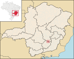
Location of Ouro Branco within Minas Gerais
Brazil location map.svg
Red pog.svg
Ouro Branco
Localization of Ouro Branco in Brazil
Coordinates: 20°31′15″S43°41′31″W / 20.52083°S 43.69194°W / -20.52083; -43.69194
Country Flag of Brazil.svg  Brazil
Region Southeast
State Bandeira de Minas Gerais.svg  Minas Gerais
Population
 (2020 [1] )
  Total39,867
Time zone UTC−3 (BRT)

Ouro Branco is a Brazilian municipality located in the state of Minas Gerais. The city belongs to the Mesoregion Metropolitana de Belo Horizonte and to the Microregion of Conselheiro Lafaiete. As of 2020, the city has a population of 39,867 inhabitants. The name "Ouro Branco" means "White Gold", as opposed to "Black Gold" - Ouro Preto. The city was an important base on the transportation route from the mines of Minas Gerais to the coast. [2]

Contents

See also

Related Research Articles

<span class="mw-page-title-main">Minas Gerais</span> State in Southeastern Brazil

Minas Gerais is one of the 27 federative units of Brazil, being the fourth largest state by area and the second largest in number of inhabitants with a population of 20,539,989 according to the 2022 census. Located in the Southeast Region of the country, it is limited to south and southwest with São Paulo; Mato Grosso do Sul to the west; Goiás and the Federal District to the northwest; Bahia to the north and northeast; Espírito Santo to the east; and Rio de Janeiro to the southeast. The state's capital and largest city, Belo Horizonte, is a major urban and finance center in Brazil, being the sixth most populous municipality in the country while its metropolitan area ranks as the third largest in Brazil with just over 5.8 million inhabitants, after those of São Paulo and Rio de Janeiro. Minas Gerais' territory is subdivided into 853 municipalities, the largest number among Brazilian states.

<span class="mw-page-title-main">Ouro Preto</span> Municipality in Minas Gerais, Brazil

Ouro Preto, formerly Vila Rica, is a Brazilian municipality located in the state of Minas Gerais. The city, a former colonial mining town located in the Serra do Espinhaço mountains, was designated a World Heritage Site by UNESCO due to its Baroque colonial architecture. Ouro Preto used to be the capital of Minas Gerais from 1720 until the foundation of Belo Horizonte in 1897.

<span class="mw-page-title-main">Diamantina, Minas Gerais</span> Municipality in Minas Gerais, Brazil

Diamantina is a Brazilian municipality in the state of Minas Gerais. Its estimated population in 2020 was 47,825 in a total area of 3,870 km2.

<span class="mw-page-title-main">Mariana, Minas Gerais</span> Municipality in Southeast, Brazil

Mariana is the oldest city in the state of Minas Gerais, Brazil. It is a tourist city, founded on July 16, 1696, and retains the characteristics of a baroque city, with its churches, buildings and museums. It was the first capital of Minas Gerais.

<span class="mw-page-title-main">Visconde do Rio Branco, Minas Gerais</span> Brazilian city in the state of Minas Gerais

Visconde do Rio Branco is a Brazilian municipality in the state of Minas Gerais. As of 2020 its population is estimated to be 42,965.

<span class="mw-page-title-main">Teófilo Otoni</span> Municipality in Southeast, Brazil

Teófilo Otoni is a municipality in northeast Minas Gerais state, Brazil. The population of the municipality was 140,937 in 2020 and the area is 3,242.818 km2.

<span class="mw-page-title-main">São João del-Rei</span> Municipality in Minas Gerais, Brazil

São João del-Rei is a Brazilian municipality in the state of Minas Gerais. Founded in 1713 in homage to king John V of Portugal, the city is famed for its historic Portuguese colonial architecture. The current population is estimated at 90,225 inhabitants.

<span class="mw-page-title-main">Congonhas</span> Municipality in Southeast Brazil

Congonhas is a historical Brazilian city located in the state of Minas Gerais. It is situated 90 kilometres (56 mi) south from Belo Horizonte, the capital of state of Minas Gerais, by the highway BR-040. As of 2020, the city had a population of 55,309.

<span class="mw-page-title-main">Santa Bárbara, Minas Gerais</span> Municipality in Southeast, Brazil

Santa Bárbara is a Brazilian municipality founded in 1704 and located in the state of Minas Gerais. It is a historic town on the Gold Circuit of Minas Gerais, located ninety-eight kilometres from Belo Horizonte, in the centre of the Estrada Real. The bucolic landscape, with its churches, roofs and backyards at the foot of the imposing Serra do Caraça makes Santa Bárbara one of the most beautiful towns in Minas Gerais. Despite the current increase in economic development, it is a peaceful and welcoming town with simple and hospitable people who preserve their traditions and live an active cultural life. The 6th President of Brazil, Afonso Pena was born in Santa Bárbara.

<span class="mw-page-title-main">Paracatu, Minas Gerais</span> Municipality in Southeast, Brazil

Paracatu is a municipality in the state of Minas Gerais in Brazil. The name is of Tupi origin, translated "good river", from "Para" (river) and "katu" (good).

<span class="mw-page-title-main">Tiradentes, Minas Gerais</span> Municipality in Minas Gerais, Brazil

Tiradentes is a municipality in the Brazilian state of Minas Gerais. It is located at 21°06′37″S44°12′41″W, has an area of 83.5 km², and a maximum elevation above sea level of 927 m. Tiradentes had an estimated population of 10,960, as of 2020. The original village was established in 1702 and became a city on 19 January 1718. In 1889 the city was renamed from Vila de São José do Rio das Mortes in honour of the national hero who was born nearby.

<span class="mw-page-title-main">Ponte Nova</span> Municipality in central-eastern Minas Gerais state, Brazil

Ponte Nova is a municipality in central-eastern Minas Gerais state, Brazil.

<span class="mw-page-title-main">Sabará</span> Municipality in Southeast, Brazil

Sabará is a Brazilian municipality located in the state of Minas Gerais. The city belongs to the Belo Horizonte metropolitan region and to the associated microregion.

<span class="mw-page-title-main">Conceição do Mato Dentro</span> Place in Southeast, Brazil

Conceição do Mato Dentro is a Brazilian municipality located in the state of Minas Gerais. The city belongs to the mesoregion Metropolitana de Belo Horizonte and to the microregion of Conceição do Mato Dentro.

<span class="mw-page-title-main">Diogo de Vasconcelos</span> Brazilian city

Diogo de Vasconcelos is a city in the municipality of Ouro Preto in the Brazilian state of Minas Gerais. As of 2020, the estimated population was 3,790.

<span class="mw-page-title-main">Frei Gaspar</span> Municipality in Southeast, Brazil

Frei Gaspar is a Brazilian municipality located in the northeast of the state of Minas Gerais. Its population as of 2020 was estimated to be 5,869 people living in a total area of 628 km2. The city belongs to the mesoregion of Vale do Mucuri and to the microregion of Teófilo Otoni. It became a municipality in 1962.

<span class="mw-page-title-main">Ouro Verde de Minas</span> Brazilian municipality located in the northeast of the state of Minas Gerais

Ouro Verde de Minas is a Brazilian municipality located in the northeast of the state of Minas Gerais. Its population as of 2020 was estimated to be 5,914 people living in a total area of 174 km2. The city belongs to the mesoregion of Vale do Mucuri and to the micro-region of Teófilo Otoni. It became a municipality in 1962.

<span class="mw-page-title-main">Ouro Fino</span> Municipality in Southeast, Brazil

Ouro Fino is a city situated in the state of Minas Gerais in the Southeastern Region of Brazil.

<span class="mw-page-title-main">Immediate Geographic Region of Conselheiro Lafaiete</span> Urban administrative region in Minas Gerais, Brazil

The Immediate Geographic Region of Conselheiro Lafaiete is one of the 10 immediate geographic regions in the Intermediate Geographic Region of Barbacena, one of the 70 immediate geographic regions in the Brazilian state of Minas Gerais and one of the 509 of Brazil, created by the National Institute of Geography and Statistics (IBGE) in 2017.

<span class="mw-page-title-main">Immediate Geographic Region of São João del-Rei</span> Urban administrative region in Minas Gerais, Brazil

The Immediate Geographic Region of São João del-Rei is one of the 10 immediate geographic regions in the Intermediate Geographic Region of Barbacena, one of the 70 immediate geographic regions in the Brazilian state of Minas Gerais and one of the 509 of Brazil, created by the National Institute of Geography and Statistics (IBGE) in 2017.

References

  1. IBGE 2020
  2. "IBGE | Brasil em SĂntese". Cidades.ibge.gov.br. Retrieved 2022-08-26.