Nova Lima

Last updated
Nova Lima
Municipality of Nova Lima
Igreja Matriz de Nova Lima e o Teatro Municipal.jpg
Biblioteca Municipal de Nova Lima.jpg
Bicame, Nova Lima.png
Concordia 02 04 2018 (3).jpg
Igreja Matriz Nossa Senhora do Pilar.jpg
Nova Lima - Camara dos Vereadores.jpg
BH-NovaLima.jpg
Flag of Nova Lima.png
Coat of Arms of Nova Lima.png
MinasGerais Municip NovaLima.svg
Location in Minas Gerais
Brazil location map.svg
Red pog.svg
Nova Lima
Location in Brazil
Coordinates: 19°59′09″S43°50′49″W / 19.98583°S 43.84694°W / -19.98583; -43.84694 Coordinates: 19°59′09″S43°50′49″W / 19.98583°S 43.84694°W / -19.98583; -43.84694
CountryFlag of Brazil.svg  Brazil
State Bandeira de Minas Gerais.svg  Minas Gerais
Region Southeast
Intermediate Region Belo Horizonte
Immediate Region Belo Horizonte
Incorporated February 5, 1891 [1]
Government
  MayorVitor Penido (DEM) [2]
Area
[3]
  Total165,425 sq mi (428,449 km2)
Elevation
2,460 ft (750 m)
Population
 (2020) [4]
  Total96,157
Time zone UTC−3 (BRT)
CEP
34000-000
Area code 31
HDI (2010)0.813 – very high [5]
Website www.novalima.mg.gov.br
Belo Horizonte and Environs Belo Horizonte (OSM-2014).png
Belo Horizonte and Environs

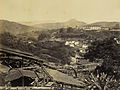
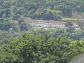
Nova Lima is a municipality of about 87,000 people, whose downtown is located about 20 kilometers south of Belo Horizonte, the capital of the south-eastern Brazilian state of Minas Gerais. [6] Mining is one of the main economical activities of the city, including the extraction of Iron Ore and Gold. The most famous mine in the city is Morro Velho (Old Hill), a gold mine of 2,700 metres (8,900 ft) depth.

Contents

History

Historically, the city was known as Campos de Congonhas, Congonhas de Sabará and until 1923 as Villa Nova de Lima. [7]

Location

The city belongs to the mesoregion Metropolitana de Belo Horizonte and to the microregion of Belo Horizonte.

The city is home to several mines, including the Morro Velho, Mostardas, and Rio de Peixe mines. A number of minerals are extracted from these and other sites in and around the city, including gold.

The St. John Del Rey Mining Company was founded by British interests in 1834 for the extraction of gold and also caused the settlement of some 150 families from Britain which led to the establishment of the Anglican Church in town.

The municipality contains the 912 hectares (2,250 acres) Mata do Jambreiro Private Natural Heritage Reserve, a protected area operated by the State Forestry Institute in partnership with the MBR mining company. [8] It contains part of the 3,941 hectares (9,740 acres) Serra do Rola-Moça State Park, created in 1994. [9] It also contains a small part of the 31,270 hectares (77,300 acres) Serra do Gandarela National Park, created in 2014. [10]

Sports

The city is home to the Villa Nova Atlético Clube, the second-oldest football club of Minas Gerais still active. The club was a major force from the 1930s until the early 1950s and won in that period five state championships. It is still a regular participant in the first division of Minas Gerais. From the late 1920s until the end of the 1930s the Sport Club Retiro also took part in the state championship. With José Perácio in 1938 and Luiz Carlos Ferreira "Luizinho" in 1982 two players born in Nova Lima represented Brazil in World Cups.

Images

See also

Related Research Articles

<span class="mw-page-title-main">Belo Horizonte</span> Municipality in Southeast Region of Brazil

Belo Horizonte is the sixth-largest city in Brazil, with a population around 2.7 million and with a metropolitan area of 6 million people. It is the 13th-largest city in South America and the 18th-largest in the Americas. The metropolis is anchor to the Belo Horizonte metropolitan area, ranked as the third-most populous metropolitan area in Brazil and the 17th-most populous in the Americas. Belo Horizonte is the capital of the state of Minas Gerais, Brazil's second-most populous state. It is the first planned modern city in Brazil.

<span class="mw-page-title-main">Minas Gerais</span> State in Southeastern Brazil

Minas Gerais is a state in Southeastern Brazil. It ranks as the second most populous, the third by gross domestic product (GDP), and the fourth largest by area in the country. The state's capital and largest city, Belo Horizonte, is a major urban and finance center in Latin America, and the sixth largest municipality in Brazil, after the cities of São Paulo, Rio de Janeiro, Salvador, Brasília and Fortaleza, but its metropolitan area is the third largest in Brazil with just over 5.8 million inhabitants, after those of São Paulo and Rio de Janeiro. Nine Brazilian presidents were born in Minas Gerais, the most of any state. The state has 10.1% of the Brazilian population and is responsible for 8.7% of the Brazilian GDP.

<span class="mw-page-title-main">Ouro Preto</span> Municipality in Minas Gerais, Brazil

Ouro Preto, formerly Vila Rica, is a city in and former capital of the state of Minas Gerais, Brazil, a former colonial mining town located in the Serra do Espinhaço mountains and designated a World Heritage Site by UNESCO because of its outstanding Baroque Portuguese colonial architecture.

<span class="mw-page-title-main">Mariana, Minas Gerais</span> Municipality in Southeast, Brazil

Mariana is the oldest city in the state of Minas Gerais, Brazil. It is a tourist city, founded on July 16, 1696, and retains the characteristics of a baroque city, with its churches, buildings and museums. It was the first capital of Minas Gerais.

<span class="mw-page-title-main">Mineiro</span>

Mineiro, Mineirês, or the Brazilian mountain dialect, is the Brazilian Portuguese term for the characteristic accent spoken in the heart of the Brazilian state of Minas Gerais, and also in its capital, Belo Horizonte, and its historical cities. Ten million people, about half of the state's population, speak it.

<span class="mw-page-title-main">Santa Bárbara, Minas Gerais</span> Municipality in Southeast, Brazil

Santa Bárbara is a Brazilian municipality founded in 1704 and located in the state of Minas Gerais.

Morro Velho, also called AngloGold Ashanti Brasil Mineração, after its current owner AngloGold Ashanti, is a complex of gold mines located near the city of Nova Lima in the Minas Gerais state of Brazil.

<span class="mw-page-title-main">Sabará</span> Municipality in Southeast, Brazil

Sabará is a Brazilian municipality located in the state of Minas Gerais. The city belongs to the Belo Horizonte metropolitan region and to the associated microregion.

<span class="mw-page-title-main">Caeté</span> Municipality in Southeast, Brazil

Caeté is a Brazilian municipality located in the state of Minas Gerais. The city belongs to the mesoregion Metropolitana de Belo Horizonte and to the microregion of Belo Horizonte.

<span class="mw-page-title-main">Itabira</span> Municipality in Southeast, Brazil

Itabira is a Brazilian municipality and a major city in the state of Minas Gerais. The city belongs to the Belo Horizonte metropolitan area mesoregion and to the Itabira microregion.

<span class="mw-page-title-main">Ibirité</span> Municipality in Minas Gerais, Brazil

Ibirité is a Brazilian municipality located in the state of Minas Gerais. The city belongs to the mesoregion Metropolitana de Belo Horizonte and to the microregion of Belo Horizonte. Its population in 2020 was 182,153.

<span class="mw-page-title-main">Baependi</span> Municipality in Minas Gerais, Brazil

Baependi is a Brazilian municipality located in the state of Minas Gerais.

<span class="mw-page-title-main">Brumadinho</span> Municipality in Minas Gerais, Brazil

Brumadinho is a Brazilian municipality in the state of Minas Gerais. The city belongs to the Belo Horizonte metropolitan mesoregion and to the microregion of Belo Horizonte. Brumadinho is at an altitude of 880 m. In 2020 the population was 40,666. The municipality is on the Paraopeba River.

<span class="mw-page-title-main">Raposos</span> Municipality in Minas Gerais, Brazil

Raposos is a Brazilian municipality located in the state of Minas Gerais. The city belongs to the mesoregion Metropolitana de Belo Horizonte and to the microregion of Belo Horizonte.

<span class="mw-page-title-main">Rio Acima</span> Municipality of Brazil

Rio Acima is a Brazilian municipality located in the state of Minas Gerais. The city belongs to the mesoregion Metropolitana de Belo Horizonte and to the microregion of Belo Horizonte. As of 2020, the estimated population was 10,420.

<span class="mw-page-title-main">Santo Antônio do Rio Abaixo</span> Human settlement in Brazil

Santo Antônio do Rio Abaixo is a Brazilian municipality located in the state of Minas Gerais. The city belongs to the mesoregion of Belo Horizonte and to the microregion of Conceição do Mato Dentro. The estimated population in 2020 was 1,760 inhabitants.

<span class="mw-page-title-main">Das Velhas River</span> River in Minas Gerais, Brazil

The das Velhas River, is by length the major tributary of the basin of the São Francisco river. Its water flows into that river at a place called Barra do Guaicuí, in the municipality of Várzea da Palma, Minas Gerais. The source was found to be the Andorinhas waterfall located in the municipality of Ouro Preto.

<span class="mw-page-title-main">Serra do Gandarela National Park</span>

Serra do Gandarela National Park is a national park in the state of Minas Gerais, Brazil. It protects a mountainous region holding a remnant of Atlantic Forest that is an important source of water for the city of Belo Horizonte.

The Saint John d'El Rey Mining Company was a British mining company that operated in Brazil in the 19th and 20th centuries. The company employed skilled miners from Cornwall and elsewhere in Britain in its gold mines in the state of Minas Gerais, and also employed black slaves.

<span class="mw-page-title-main">Serra do Rola-Moça State Park</span>

The Serra do Rola-Moça State Park is a state park in the state of Minas Gerais, Brazil. It protects a rugged area in the transition zone between cerrado and Atlantic Forest. Springs in the park are important to the water supply of the state capital, Belo Horizonte.

References

  1. "Nova Lima, Minas Gerais - Histórico" (PDF). IBGE - Brazilian Geography and Statistics Institute. Retrieved November 24, 2016.
  2. Cipriani, Juliana (September 21, 2016). "Nova Lima tem novo prefeito faltando menos de duas semanas para a eleição" [Nova Lima has a new mayor just two days before the elections]. Estado de Minas. Retrieved November 24, 2016.
  3. "Área territorial oficial" [Official Territorial Area] (in Portuguese). Brazilian Institute of Geography and Statistics (IBGE). October 10, 2002. Retrieved December 5, 2010.
  4. IBGE 2020
  5. "Archived copy" (PDF). United Nations Development Programme (UNDP). Archived from the original (PDF) on July 8, 2014. Retrieved August 1, 2013.{{cite web}}: CS1 maint: archived copy as title (link)
  6. "Estimativa População 2013" [Population estimation - 2013](PDF) (in Portuguese). Brazilian Institute of Geography and Statistics (IBGE). August 29, 2013. Retrieved August 29, 2013.
  7. Sobre a nossa Nova Lima Archived 2014-05-12 at the Wayback Machine , Sou Nova Lima, August 22, 2013.
  8. "Estação Ecológica Mata de Jambreiros", Ambientes Brasil (in Portuguese), 5 May 2010, retrieved April 27, 2016
  9. Parque Estadual da Serra do Rola-Moça (in Portuguese), IEF, retrieved January 16, 2017
  10. PARNA de Serra do Gandarela (in Portuguese), ISA: Instituto Socioambiental, retrieved June 12, 2016
Commons-logo.svg Media related to Nova Lima at Wikimedia Commons