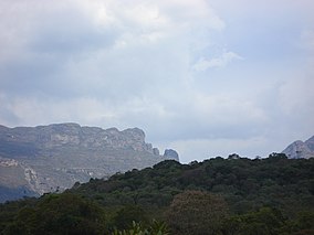
Serra do Gandarela National Park (Portuguese: Parque Nacional da Serra do Gandarela) is a national park in the state of Minas Gerais, Brazil. It protects a mountainous region holding a remnant of Atlantic Forest that is an important source of water for the city of Belo Horizonte.
The Serra do Gandarela is a natural sanctuary about 40 kilometres (25mi) from Belo Horizonte.[1] Serra do Gandarela National Park covers parts of the municipalities of Caeté (2.37%), Itabirito (10.01%), Mariana (0.23%), Nova Lima (1.99%), Ouro Preto (9.91%, Raposos (10.8%), Rio Acima (19.46%) and Santa Bárbara (45.22%) in the state of Minas Gerais.[2] Part of the park is in the Belo Horizonte metropolitan region.[1] The park has an area of 31,270.83 hectares (77,271.9 acres).[3]
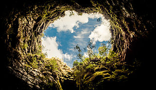
The park is in the Atlantic Forest biome.[3] It holds the largest intact remnant of Atlantic Forest in Minas Gerais, mostly in excellent condition. Waters from the Serra do Gandarela feed the basins of the Das Velhas River, a tributary of the São Francisco River, the Piracicaba River and the Doce River. The Das Velhas provides more than 60% of the water for Belo Horizonte and 45% of the water for the metropolitan region. The water is clean and requires little treatment. The Serra do Gandarela contains over 100 caves. Some support unique species, and some contain archaeological sites.[1]
At the request of a number of civil organisations the Chico Mendes Institute for Biodiversity Conservation (ICMBio) prepared a proposal for creating the park, protecting a large part of the Belo Horizonte water sources, which were seriously threatened by mining for iron ore. The original proposal in 2010 was to protect an area of 38,220 hectares (94,400 acres), but this was reduced before the park was created.[1] Public discussions about the project were started on 10 April 2012.[2]
The park was created by federal decree on 13 October 2014.[3] The decree also added over 30,000 hectares (74,000 acres) to the Médio Juruá Extractive Reserve in Amazonas and created the Guaricana National Park in Paraná and the Nascentes Geraizeiras Sustainable Development Reserve in Minas Gerais.[4] The national park is classed as IUCN protected area category II (national park). The purpose is to preserve samples of biological, geological, speleological and hydrological heritage associated with the Quadrilátero Ferrífero formations, including alpine meadows, remnants of semi-deciduous forest, aquifer recharge areas and the scenery of mountains, plateaus, rivers, waterfalls and natural vegetation.[5]
The park boundaries did not satisfy the requests of the social organisations who had been consulted, since it did not fully protect the geological formations holding the water supply aquifers. The area of Vale's R$4 billion Apollo iron ore project was excluded. On the other hand, the park included areas traditionally used by the surrounding communities, causing potential conflict.[2] Roberto Vizentin, president of ICMBio, defended the reduction from 38,200 to 31,200 hectares (94,000 to 77,000 acres) and the high risk of pollution from mining as a necessary compromise given the relatively low Human Development Index in the region.[6]
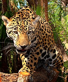
Fauna
The jaguar is a conspicuous inhabitant of Serra do Gandarela National Park.
The Iron Quadrangle (Quadrilátero Ferrífero), where the park is located, is a transition region between the biomasses of the Atlantic Forest and Cerrado, which contributes to increase species diversity, the presence of typical species of the two biomasses.[7]
1 2 Serra do Gandarela: Possibilidade de Ampliação das Unidades de Conservação no Quadrilátero Ferrífero-MG. Wanderson Lopes Lamounier, Vilma Lúcia Macagnan Carvalho e André Augusto Rodrigues Salgado. Revista do Departamento de Geografia – Universidad de São Paulo, Volume 22 (2011), p. 171-192.
Sources
Augusto Barros, "A Serra", Aguas do Gandarela (in Portuguese), archived from the original on 2016-06-16, retrieved 2016-06-12
Nova Lima is a municipality of about 87,000 people, whose downtown is located about 20 kilometers south of Belo Horizonte, the capital of the south-eastern Brazilian state of Minas Gerais. Mining is one of the main economical activities of the city, including the extraction of Iron Ore and Gold. The most famous mine in the city is Morro Velho, a gold mine of 2,700 metres (8,900 ft) depth.
The Serra do Cipó National Park is a national park in the state of Minas Gerais, Brazil.
Serra da Canastra National Park is a national park in the Canastra Mountains of the state of Minas Gerais, Brazil.
Raposos is a Brazilian municipality located in the state of Minas Gerais. The city belongs to the mesoregion Metropolitana de Belo Horizonte and to the microregion of Belo Horizonte.
Rio Acima is a Brazilian municipality located in the state of Minas Gerais. The city belongs to the mesoregion Metropolitana de Belo Horizonte and to the microregion of Belo Horizonte. As of 2020, the estimated population was 10,420.
São Joaquim National Park is a National park in the state of Santa Catarina, Brazil.
Serra Geral National Park is a national park in the states of Rio Grande do Sul and Santa Catarina, Brazil.
Campos Gerais National Park is a national park in the state of Paraná, Brazil.
The Serra do Pardo National Park is a National park in the state of Pará, Brazil.
Serra de Itabaiana National Park is a national park in the state of Sergipe, Brazil.
Saint-Hilaire/Lange National Park is a national park in Paraná, Brazil.
Rio Novo National Park is a national park in the state of Pará, Brazil.
Mapinguari National Park is a national park in the states of Rondônia and Amazonas, Brazil. It covers a large area of Amazon rainforest. The boundaries have been adjusted several times.
The Serra das Lontras National Park (Portuguese: Parque Nacional da Serra das Lontras is a national park in the state of Bahia, Brazil. It protects a rugged area of Atlantic Rainforest with a wide range of bird species, including several that are threatened with extinction.
The Serra das Confusões National Park is a national park in the state of Piauí, Brazil.
Acari National Park is a national park in the state of Amazonas, Brazil.
The Nascentes Geraizeiras Sustainable Development Reserve (Portuguese: Reserva de Desenvolvimento Sustentável Nascentes Geraizeiras is a sustainable development reserve in the Cerrado ecoregion within the state of Minas Gerais, Brazil.
The Guaricana National Park is a national park in the state of Paraná, Brazil. It protects a mountainous area holding a remnant of Atlantic Forest.
The Médio Juruá Extractive Reserve is an extractive reserve in the state of Amazonas Brazil.
The Serra Negra State Park Portuguese: Parque Estadual da Serra Negra is a state park in the state of Minas Gerais, Brazil. It protects a mountainous area in the Atlantic Forest biome, an important source of water in a dry region, and a potential source of tourism revenue in an area with many social problems.
This page is based on this Wikipedia article Text is available under the CC BY-SA 4.0 license; additional terms may apply. Images, videos and audio are available under their respective licenses.