Mariana, Minas Gerais

Last updated
Mariana
Municipality of Mariana
Igrejasmariana2006.jpg
Conjunto arquitetonico mariana.jpg
Casa de Camara e Cadeia, fachada principal.jpg
Estacao de Trem.jpg
Pelourinho da Praca Minas Gerais.JPG
DSC 0850 Casaroes com agencia do Banco do Brasil.jpg
Vista de Mariana MG a partir da torre da Igreja de Sao Pedro dos Clerigos.JPG
Mariana (Bandeira).jpg
Brasao Mariana.png
MinasGerais Municip Mariana.svg
Location in the State of Minas Gerais
Brazil location map.svg
Red pog.svg
Mariana
Location in Brazil
Coordinates: 20°22′42″S43°23′59″W / 20.37833°S 43.39972°W / -20.37833; -43.39972
Country Flag of Brazil.svg  Brazil
Region Southeast
State Bandeira de Minas Gerais.svg  Minas Gerais
FoundedJuly 16, 1696
Government
   Mayor Duarte Eustáquio Júnior (PPS) [1]
Area
  Total1,194.208 km2 (461.086 sq mi)
Elevation
899 m (2,949 ft)
Population
 (2021) [2]
  Total61,830
  Density45.40/km2 (117.6/sq mi)
Demonym Marianense [3]
Time zone UTC−3 (BRT)
CEP postal code
35420-000
Area code +55 31
HDI (2010)0.742 – high [4]
Website www.mariana.mg.gov.br

Mariana is the oldest city in the state of Minas Gerais, Brazil. It is a tourist city, founded on July 16, 1696, and retains the characteristics of a baroque city, with its churches, buildings and museums. It was the first capital of Minas Gerais.

Other historical cities in Minas Gerais are Ouro Preto, São João del-Rei, Diamantina, Tiradentes, Congonhas and Sabará.

It has an area of 1,194.208 square kilometres (461.086 sq mi). [5]

The municipality contains a very small part of the 31,270 hectares (77,300 acres) of Serra do Gandarela National Park, created in 2014. [6]

In 2015, it suffered a major dam disaster.

Related Research Articles

<span class="mw-page-title-main">Ouro Preto</span> Municipality in Minas Gerais, Brazil

Ouro Preto, formerly Vila Rica, is a Brazilian municipality located in the state of Minas Gerais. The city, a former colonial mining town located in the Serra do Espinhaço mountains, was designated a World Heritage Site by UNESCO due to its Baroque colonial architecture. Ouro Preto used to be the capital of Minas Gerais from 1720 until the foundation of Belo Horizonte in 1897.

<span class="mw-page-title-main">Montes Claros</span> Municipality in Southeast, Brazil

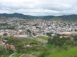
Montes Claros is a city located in northern Minas Gerais state, in Brazil. It is located north of the state capital, about 422 km away from it. The population is 413,487 in an area of 3,569 km2 (1,378 sq mi). It was made a seat of a municipality in 1831 and attained city status in 1857.

<span class="mw-page-title-main">Almenara, Minas Gerais</span> Municipality in Southeast, Brazil

Almenara, is a municipality in the northeast of the Brazilian state of Minas Gerais. Situated on the Jequitinhonha River it is the largest city in that river valley. Its 2020 population was estimated at 42,143 and the municipal area was 2,301 km².

<span class="mw-page-title-main">São João del-Rei</span> Municipality in Minas Gerais, Brazil

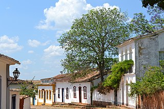
São João del-Rei is a Brazilian municipality in the state of Minas Gerais. Founded in 1713 in homage to king John V of Portugal, the city is famed for its historic Portuguese colonial architecture. The current population is estimated at 90,225 inhabitants.

<span class="mw-page-title-main">Santa Bárbara, Minas Gerais</span> Municipality in Southeast, Brazil

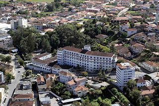
Santa Bárbara is a Brazilian municipality founded in 1704 and located in the state of Minas Gerais.

<span class="mw-page-title-main">Nova Lima</span> Municipality in Minas Gerais, Brazil

Nova Lima is a municipality of about 87,000 people, whose downtown is located about 20 kilometers south of Belo Horizonte, the capital of the south-eastern Brazilian state of Minas Gerais. Mining is one of the main economical activities of the city, including the extraction of Iron Ore and Gold. The most famous mine in the city is Morro Velho, a gold mine of 2,700 metres (8,900 ft) depth.

<span class="mw-page-title-main">Tiradentes, Minas Gerais</span> Municipality in Minas Gerais, Brazil

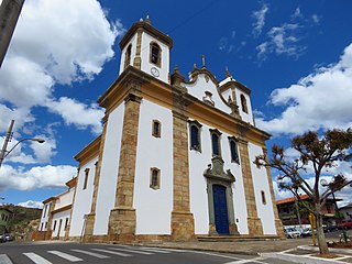
Tiradentes is a municipality in the Brazilian state of Minas Gerais. It is located at 21°06′37″S44°12′41″W, has an area of 83.5 km², and a maximum elevation above sea level of 927 m. Tiradentes had an estimated population of 10,960, as of 2020. The original village was established in 1702 and became a city on 19 January 1718. In 1889 the city was renamed from Vila de São José do Rio das Mortes in honour of the national hero who was born nearby.

<span class="mw-page-title-main">Caeté</span> Municipality in Southeast, Brazil

Caeté is a Brazilian municipality located in the state of Minas Gerais.

<span class="mw-page-title-main">Arantina</span> Municipality in Minas Gerais, Brazil

Arantina is a Brazilian municipality located in the state of Minas Gerais. Its population as of 2020 is estimated to be 2,787 people living in a total area of 89.382 km². The city belongs to the mesoregion of Sul and Sudoeste de Minas and to the microregion of Andrelândia.

<span class="mw-page-title-main">Pará de Minas</span> Municipality in Southeast, Brazil

Pará de Minas is a Brazilian municipality located in the state of Minas Gerais.

<span class="mw-page-title-main">Brumadinho</span> Municipality in Minas Gerais, Brazil

Brumadinho is a Brazilian municipality in the state of Minas Gerais. The city belongs to the Belo Horizonte metropolitan mesoregion and to the microregion of Belo Horizonte. Brumadinho is at an altitude of 880 m. In 2020 the population was 40,666. The municipality is on the Paraopeba River.

<span class="mw-page-title-main">Entre Rios de Minas</span> Place in Southeast, Brazil

Entre Rios de Minas is a Brazilian municipality located in the state of Minas Gerais. The city belongs to the mesoregion Metropolitana de Belo Horizonte and to the microregion of Conselheiro Lafaiete.

<span class="mw-page-title-main">Jacinto, Minas Gerais</span> Municipality in Southeast, Brazil

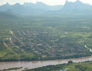
Jacinto is a Brazilian municipality located in the northeast of the state of Minas Gerais. Jacinto is located on the right bank of the Jequitinhonha River. It is 44 kilometers east of Almenara.

<span class="mw-page-title-main">Bonito de Minas</span> Place in Southeast, Brazil

Bonito de Minas is a municipality in the northeast of the Brazilian state of Minas Gerais. As of 2020 the population was 11,369 in a total area of 3,901 km2. The elevation is 629 meters. It became a municipality in 1995.

Santa Vitória is a municipality in the west of the Brazilian state of Minas Gerais. As of 2020, the population was estimated at 19,872. It became a municipality in 1948.

<span class="mw-page-title-main">Itaúna</span> Municipality in Southeast, Brazil

Itaúna is a municipality in the state of Minas Gerais in the Southeast region of Brazil.

<span class="mw-page-title-main">Lambari, Minas Gerais</span> Municipality in Southeast, Brazil

Lambari is a municipality in the state of Minas Gerais in the Southeast region of Brazil.

<span class="mw-page-title-main">São João Evangelista</span> Municipality in Southeast, Brazil

São João Evangelista is a municipality in the state of Minas Gerais in the Southeast region of Brazil.

<span class="mw-page-title-main">Peçanha</span> Municipality in Southeast, Brazil

Peçanha is a municipality in the state of Minas Gerais in the Southeast region of Brazil.

<span class="mw-page-title-main">Rio Preto, Minas Gerais</span> Place in Southeast, Brazil

Rio Preto is a municipality in the state of Minas Gerais in the Southeast region of Brazil.

References

  1. "Prefeitura de Mariana - Gabinete do Prefeito" [Mariana City Hall - Mayor's office] (in Portuguese). Mariana City Hall. Archived from the original on 2015-11-23. Retrieved 2015-11-24.
  2. "IBGE Mariana". IBGE . Retrieved 14 March 2022.
  3. "IBGE - Cidades@". O Brasil Município por Município. Brazilian Institute of Geography and Statistics (IBGE) . Retrieved 2015-05-27.
  4. "Archived copy" (PDF). United Nations Development Programme (UNDP). Archived from the original (PDF) on July 8, 2014. Retrieved August 1, 2013.{{cite web}}: CS1 maint: archived copy as title (link)
  5. "Área territorial oficial" [Official Territorial Area] (in Portuguese). Brazilian Institute of Geography and Statistics (IBGE). 2002-10-10. Retrieved 2014-12-03.
  6. PARNA de Serra do Gandarela (in Portuguese), ISA: Instituto Socioambiental, retrieved 2016-06-12