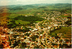
Bicas | |
---|---|
Coordinates: 21°43′30″S43°03′32″W / 21.72500°S 43.05889°W | |
Country | Brazil |
Region | Southeast |
State | Minas Gerais |
Mesoregion | Zona da Mata |
Microregion | Juiz de Fora |
Founded | September 7th, 1923 |
Government | |
• Mayor | Geraldo Magela Longo dos Santos |
Area | |
• Total | 139,538 km2 (53,876 sq mi) |
Elevation | 600.0 m (1,968.5 ft) |
Population (2020 [2] ) | |
• Total | 14,554 |
Time zone | UTC−3 (BRT) |
HDI (2000) | 0.799 |
Website | Bicas, Minas Gerais |
Bicas is a Brazilian municipality in the state of Minas Gerais. As of 2020 [update] its population is estimated to be 14,554 inhabitants.
Initially a breakpoint for salesmen in the 18th century, Bicas obtained its independence from the city of Guarará in 1923. It was an attraction point for Italian immigrants and other nationalities.
Until the 1970s, Bicas had a full-working train station and an active RFFSA (the extinct state railroad company) branch for repairing wagons. All this structure was dismantled and today the train station exists only as a historic site. Currently, Bicas has an economy based on commerce, agriculture and farming.
Annual Farming Expositions, with bull-riding and rodeos, cattle commerce and local products - typically in the last week of July of every year - are a tradition of several cities in Zona da Mata, and the Farming Exposition of Bicas is one of the most famous, attracting thousands of tourists from several parts of the country.
Guarani is a municipality located in the Zona da Mata within the state of Minas Gerais, Brazil. The population is 8,918 in an area of 264 km². The average elevation is 440m above the sea level within the urban limits, reaching up to 1,434m in the mountainous area located in the outskirts. The town was named after the biggest native tribe which dwelt in Brazil before the Colonial Period, the Guaranis.
Mariana is the oldest city in the state of Minas Gerais, Brazil. It is a tourist city, founded on July 16, 1696, and retains the characteristics of a baroque city, with its churches, buildings and museums. It was the first capital of Minas Gerais.
São João del-Rei is a Brazilian municipality in the state of Minas Gerais. Founded in 1713 in homage to King John V of Portugal, the city is famed for its historic Portuguese colonial architecture. The current population is estimated at 93,778 inhabitants.
Goiatuba is a municipality in south-central Goiás state, Brazil. The population was 34,202 in a total area of 2,470.3 km2. Goiatuba is a large producer of grains, especially soybeans and corn.
Confins is a Brazilian municipality located in the state of Minas Gerais. Its population as of 2020 is estimated to be 6,800 people. The area of the municipality is 42.008 km². The city belongs to the mesoregion Metropolitana de Belo Horizonte and to the microregion of Belo Horizonte. It is home of the international airport of Belo Horizonte, Tancredo Neves International Airport.
Grão Mogol is a Brazilian municipality located in the north of the state of Minas Gerais. In 2020 the population was 15,890 in a total area of 3,890 km2. The elevation is 829 meters. It became a municipality in 1840.
Jacinto is a Brazilian municipality located in the northeast of the state of Minas Gerais. Jacinto is located on the right bank of the Jequitinhonha River. It is 44 kilometers east of Almenara.
Palmópolis is a municipality in the northeast of the Brazilian state of Minas Gerais. Its population in 2020 was 5,349 inhabitants in a total area of 436 km².
Bonito de Minas is a municipality in the northeast of the Brazilian state of Minas Gerais. As of 2020 the population was 11,369 in a total area of 3,901 km2. The elevation is 629 meters. It became a municipality in 1995.
Montezuma is a municipality in the northeast of the Brazilian state of Minas Gerais. It is isolated, and the inhabitants are poor, mainly engaged in cattle raising and small-scale farming. It became a municipality in 1993.
Lagoa Grande is a municipality in the northeast of the Brazilian state of Minas Gerais. Its population in 2020 was 9,608 inhabitants in a total area of 1,220 km².
Lontra is a municipality in the north of the Brazilian state of Minas Gerais. As of 2020, the population was 9,714 in a total area of 257 km². It became a municipality in 1993.
Patis is a municipality in the north of the Brazilian state of Minas Gerais. As of 2010 the population was 5,579 in a total area of 444 km2. It became a municipality in 1995.
Capinópolis is a municipality in the west of the Brazilian state of Minas Gerais. As of 2020 the population was 16,234 in a total area of 621 km². It became a municipality in 1953. The name means "city of grass".
Santa Vitória is a municipality in the west of the Brazilian state of Minas Gerais. As of 2020, the population was estimated at 19,872. It became a municipality in 1948.
Itaipé is a Brazilian municipality located in the northeast of the state of Minas Gerais. Its population as of 2020 was estimated to be 12,836 people living in a total area of 483 km2. The city belongs to the mesoregion of Vale do Mucuri and to the microregion of Teófilo Otoni. It became a municipality in 1962.
Piranguinho is a municipality in the state of Minas Gerais in the Southeast region of Brazil.
The Intermediate Geographic Region of Juiz de Fora is one of the 13 intermediate geographic regions in the Brazilian state of Minas Gerais and one of the 134 of Brazil, created by the National Institute of Geography and Statistics (IBGE) in 2017.
The Immediate Geographic Region of Belo Horizonte is one of the 10 immediate geographic regions in the Intermediate Geographic Region of Belo Horizonte, one of the 70 immediate geographic regions in the Brazilian state of Minas Gerais and one of the 509 of Brazil, created by the National Institute of Geography and Statistics (IBGE) in 2017.
The Immediate Geographic Region of São João Nepomuceno-Bicas is one of the 10 immediate geographic regions in the Intermediate Geographic Region of Juiz de Fora, one of the 70 immediate geographic regions in the Brazilian state of Minas Gerais and one of the 509 of Brazil, created by the National Institute of Geography and Statistics (IBGE) in 2017.