Matias Cardoso

Last updated
Location of Matias Cardoso in the state of Minas Gerais MinasGerais Municip MatiasCardoso.svg
Location of Matias Cardoso in the state of Minas Gerais

Matias Cardoso is a municipality in the north of the state of Minas Gerais in Brazil.

Contents

Location

Matias Cardoso is located on the right bank of the São Francisco River. It is 10 km. south of Manga and is 72 km. northwest of Jaíba. As of 2020 the population was 11,260 in an area of 1,938 km2. [1]

The municipality contains the 6,358 hectares (15,710 acres) Jaíba Biological Reserve, a fully protected conservation unit created in 1994. [2]

Economy

The economy is based on agriculture with emphasis on cattle raising. There were 46,000 head in 2006. The main agricultural crops were cotton, peanuts, corn, manioc, sorghum, sugarcane, and mamona—castor oil plant. The GDP was R$37,034,000 in 2005.

Health

This municipality is extremely isolated from major population centers and suffers from drought and poor soils. It is one of the poorest in the state and in the country.

(For the complete list see Frigoletto)
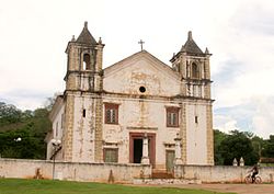
Related Research Articles

Salinas, Minas Gerais Salinas is a municipality in Minas Gerais, Brazil

Salinas is a municipality in the northeast of the Brazilian state of Minas Gerais.

Ubaí

Ubaí is a municipality in the north of the Brazilian state of Minas Gerais. As of 2020 the population was 12,599 in a total area of 821 km². It became a municipality in 1962.

Varzelândia

Varzelândia is a municipality in the north of the Brazilian state of Minas Gerais. As of 2020 the population was 19,305 in a total area of 804 km². It became a municipality in 1962.

Janaúba

Janaúba is a municipality in the north of the Brazilian state of Minas Gerais. In 2020 the population was 72,018 in a total area of 2,189 km2. The elevation is 692 meters above sea level.

Juramento

Juramento is a municipality in the north of the Brazilian state of Minas Gerais. As of 2020 the population was 4,345 in a total area of 432 km². It became a municipality in 1953.

Gameleiras

Gameleiras is a municipality in the northeast of the Brazilian state of Minas Gerais. As of 2020 the population was 5,096 in a total area of 1,733 km². The elevation is 540 meters. It became a municipality in 1997. The postal code (CEP) is 39505-000.

Jaíba

Jaíba is a municipality in the north of the Brazilian state of Minas Gerais. As of 2020 the population was 39,388 in a total area of 2,733 km2 (1,055 sq mi). The elevation is 475 metres (1,558 ft). It became a municipality in 1993. The postal code (CEP) is 39508-000.

Mamonas

Mamonas is a municipality in the north of the Brazilian state of Minas Gerais. As of 2020 the population was 6,554 in a total area of 290 km². The elevation is 681 meters. It became a municipality in 1993. The postal code (CEP) is 39516-000.

Manga, Minas Gerais Place in Brazil

Manga is a municipality in the north of the state of Minas Gerais in Brazil. It is located on the left bank of the São Francisco River. It is connected to Januária by paved BR-135, anis 112 km away. Neighboring municipalities are Matias Cardoso, Montalvânia, Miravânia, Juvenília, and São João das Missões. The distance to the state capital is 720 km. As of 2020 the population was 18,226 in an area of 1,950 km².

Itacambira

Itacambira is a Brazilian municipality located in the north of the state of Minas Gerais. In 2020 the population was 5,417 in a total area of 1,788 km². It became a municipality in 1962.

Jequitaí

Jequitaí is a Brazilian municipality located in the north of the state of Minas Gerais. In 2020 the population was 7,468 in a total area of 1,268 km². It became a municipality in 1948.

Ibiracatu

Ibiracatu is a Brazilian municipality located in the north of the state of Minas Gerais. In 2020 the population was 5,369 in a total area of 359 km2. It became a municipality in 1995.

Verdelândia

Verdelândia is a municipality in the north of the Brazilian state of Minas Gerais. As of 2020 the population was 9,443 in a total area of 1,452 km². It became a municipality in 1997.

Engenheiro Navarro

Engenheiro Navarro is a Brazilian municipality located in the north of the state of Minas Gerais. Its population as of 2020 was 7,241 people living in a total area of 632 km². The city belongs to the mesoregion of North of Minas and to the microregion of Bocaiúva. It became a municipality in 1962.

Catuji

Catuji is a Brazilian municipality located in the northeast of the state of Minas Gerais. Its population as of 2020 was estimated to be 6,257 people living in a total area of 421 km². The city belongs to the mesoregion of Vale do Mucuri and to the microregion of Teófilo Otoni. It became a municipality in 1993.

Itaipé

Itaipé is a Brazilian municipality located in the northeast of the state of Minas Gerais. Its population as of 2020 was estimated to be 12,836 people living in a total area of 483 km2. The city belongs to the mesoregion of Vale do Mucuri and to the microregion of Teófilo Otoni. It became a municipality in 1962.

Ladainha, Minas Gerais

Ladainha is a Brazilian municipality located in the northeast of the state of Minas Gerais. Its population as of 2020 was estimated to be 18,193 people living in a total area of 865 km². The city belongs to the mesoregion of Vale do Mucuri and to the microregion of Teófilo Otoni. It became a municipality in 1949.

Malacacheta

Malacacheta is a Brazilian municipality located in the northeast of the state of Minas Gerais. Its population as of 2020 was estimated to be 18,602 people living in a total area of 719 km2. The city belongs to the mesoregion of Vale do Mucuri and to the micro-region of Teófilo Otoni. It became a municipality in 1924.

Poté municipality in Minas Gerais, Brazil

Poté is a Brazilian municipality located in the northeast of the state of Minas Gerais. Its population as of 2020 was estimated to be 16,616 people living in a total area of 632 km². The city belongs to the mesoregion of Vale do Mucuri and to the micro-region of Teófilo Otoni. It became a municipality in 1938.

Pavão, Minas Gerais

Pavão is a Brazilian municipality located in the northeast of the state of Minas Gerais. Its population as of 2020 was estimated to be 8,419 people living in a total area of 599 km2. The city belongs to the mesoregion of Vale do Mucuri and to the micro-region of Teófilo Otoni. It became a municipality in 1962.

References

  1. IBGE 2020
  2. Josefina Ivonete Fagundes (2005), Sistema de Áreas Protegidas - SAP (in Portuguese), IEF - Instituto Estadual de Florestal - MG, archived from the original on 2017-02-16, retrieved 2016-04-27

See also

Coordinates: 14°49′13″S43°52′38″W / 14.82028°S 43.87722°W / -14.82028; -43.87722