Itaguara

Last updated
Location of Itaguara within Minas Gerais MinasGerais Municip Itaguara.svg
Location of Itaguara within Minas Gerais

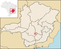
Itaguara is a Brazilian municipality in the state of Minas Gerais. Its population in 2020 was 13,435. [1]

Contents

Toponym

Itaguara is a coinage from Tupi–Guarani, meaning "wolf rock", by combining itá (rock) and guará (Wolf).

See also

Related Research Articles

<span class="mw-page-title-main">Lagoa Dourada</span> Municipality in Minas Gerais, Brazil

Lagoa Dourada is a Brazilian municipality located in the state of Minas Gerais.

<span class="mw-page-title-main">Madre de Deus de Minas</span> Town and municipality in the state of Minas Gerais, Brazil

Madre de Deus de Minas is a Brazilian municipality located in the state of Minas Gerais. The city belongs to the mesoregion of Campo das Vertentes and to the microregion of Sao Joao del Rei. In 2020, the estimated population was 5,109.

<span class="mw-page-title-main">Resende Costa</span>

Resende Costa is a Brazilian municipality located in the state of Minas Gerais. The city belongs to the mesoregion of Campo das Vertentes and to the microregion of Sao Joao del Rei. In 2020, the estimated population was 11,540.

<span class="mw-page-title-main">Piedade de Ponte Nova</span> Brazilian municipality located in the state of Minas Gerais

Piedade de Ponte Nova is a Brazilian municipality located in the state of Minas Gerais. The city belongs to the mesoregion of Zona da Mata and to the microregion of Ponte Nova. As of 2020, the estimated population was 4,140.

<span class="mw-page-title-main">Igarapé</span>

Igarapé is a Brazilian municipality located in the state of Minas Gerais. The city belongs to the mesoregion Metropolitana de Belo Horizonte and to the microregion of Belo Horizonte. In 2020 the estimated population was 43,817.

<span class="mw-page-title-main">Juatuba</span> Municipality in Minas Gerais, Brazil

Juatuba is a Brazilian municipality located in the state of Minas Gerais. The city belongs to the mesoregion Metropolitana de Belo Horizonte and to the microregion of Belo Horizonte. In 2020 the estimated population was 27,392.

<span class="mw-page-title-main">Mário Campos</span> Municipality of Brazil

Mário Campos is a Brazilian municipality located in the state of Minas Gerais. The city belongs to the mesoregion Metropolitana de Belo Horizonte and to the microregion of Belo Horizonte. As of 2010, the population was 13,192.

<span class="mw-page-title-main">São Joaquim de Bicas</span>

São Joaquim de Bicas is a Brazilian municipality located in the state of Minas Gerais. The city belongs to the mesoregion Metropolitana de Belo Horizonte and to the microregion of Belo Horizonte. As of 2020, the estimated population was 32,148.

<span class="mw-page-title-main">Sarzedo, Minas Gerais</span>

Sarzedo is a Brazilian municipality located in the state of Minas Gerais. The city belongs to the mesoregion Metropolitana de Belo Horizonte and to the microregion of Belo Horizonte. As of 2020, the estimated population was 33,413.

<span class="mw-page-title-main">Desterro de Entre Rios</span>

Desterro de Entre Rios is a Brazilian municipality located in the state of Minas Gerais. The city belongs to the mesoregion Metropolitana de Belo Horizonte and to the microregion of Conselheiro Lafaiete. As of 2020, the estimated population was 7,255.

<span class="mw-page-title-main">Queluzito</span>

Queluzito is a Brazilian municipality located in the state of Minas Gerais. The city belongs to the mesoregion Metropolitana de Belo Horizonte and to the microregion of Conselheiro Lafaiete. As of 2020, the estimated population was 1,943.

<span class="mw-page-title-main">Fervedouro</span> Municipality in Minas Gerais, Brazil

Fervedouro is a Brazilian municipality located in the state of Minas Gerais. The city belongs to the mesoregion of Zona da Mata and to the microregion of Muriaé. As of 2020, the estimated population was 11,054.

<span class="mw-page-title-main">São José do Mantimento</span>

São José do Mantimento is a Brazilian municipality located in the state of Minas Gerais. The city belongs to the mesoregion of Zona da Mata and to the microregion of Manhuaçu. As of 2020, the estimated population was 2,806.

<span class="mw-page-title-main">Cônego Marinho</span> Municipality in Minas Gerais, Brazil

Cônego Marinho is a municipality in the north of the state of Minas Gerais in Brazil. As of 2020 the population was 7,686 in an area of 1,618 km².

<span class="mw-page-title-main">Ibiaí</span> Municipality in Minas Gerais, Brazil

Ibiaí is a Brazilian municipality located in the north of the state of Minas Gerais. In 2020 the population was 8,437 in a total area of 870 km². It became a municipality in 1963.

<span class="mw-page-title-main">Jequitaí</span> Brazilian municipality located in the north of the state of Minas Gerais

Jequitaí is a Brazilian municipality located in the north of the state of Minas Gerais. In 2020 the population was 7,468 in a total area of 1,268 km2. It became a municipality in 1948.

<span class="mw-page-title-main">Diogo de Vasconcelos</span>

Diogo de Vasconcelos is a city in the microregion of Ouro Preto in the Brazilian state of Minas Gerais. As of 2020, the estimated population was 3,790.

<span class="mw-page-title-main">Carmópolis de Minas</span> Municipality in Minas Gerais, Brazil

Carmópolis de Minas is a municipality in the Brazilian state of Minas Gerais. As of 2020, the estimated population was 19,559.

<span class="mw-page-title-main">Piracema, Minas Gerais</span> Town and municipality in the state of Minas Gerais, Brazil

Piracema is a municipality in the state of Minas Gerais in the Southeast region of Brazil. As of 2020, the estimated population was 6,398.

<span class="mw-page-title-main">Immediate Geographic Region of Oliveira</span>

The Immediate Geographic Region of Oliveira is one of the 6 immediate geographic regions in the Intermediate Geographic Region of Divinópolis, one of the 70 immediate geographic regions in the Brazilian state of Minas Gerais and one of the 509 of Brazil, created by the National Institute of Geography and Statistics (IBGE) in 2017.

References

Coordinates: 20°23′31″S44°29′16″W / 20.39194°S 44.48778°W / -20.39194; -44.48778