Muzambinho

Last updated
Muzambinho
Municipality
Avenida Dr Americo Luz.jpg
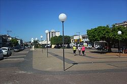
View of Dr. Américo Luz avenue
Flag of Muzambinho MG.png
Coat of arms of Muzambinho MG.png
MinasGerais Municip Muzambinho.svg
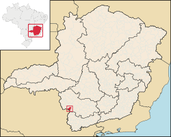
Location in Minas Gerais
Brazil location map.svg
Red pog.svg
Muzambinho
Location in Brazil
Coordinates: 21°22′33″S46°31′33″W / 21.37583°S 46.52583°W / -21.37583; -46.52583
CountryFlag of Brazil.svg Brazil
Region Southeast
State Minas Gerais
Mesoregion South and Southwest of Minas Gerais
Microregion São Sebastião do Paraíso
FoundedOctober 8th, 1860
Incorporated November 12th, 1878
Government
  MayorIvan Antônio de Freitas
Area
[1]
  Total
157,930 sq mi (409,036 km2)
Elevation
3,600 ft (1,100 m)
Population
 (2020 [2] )
  Total
20,545
Time zone UTC−3 (BRT)
CEP postal code
37890-000
Area code 35
HDI (2008) [3] 0.801
Website Official Website

Muzambinho is a municipality in the state of Minas Gerais in the Southeast region of Brazil. [3] [4] [5] [6]

See also

References

  1. IBGE (2002-10-10). "Área territorial oficial" (in Portuguese). IBGE. Retrieved 2015-03-30.
  2. IBGE 2020
  3. 1 2 "Ranking decrescente do IDH-M dos municípios do Brasil" (in Portuguese). Programa das Nações Unidas para o Desenvolvimento (PNUD). 2000. Archived from the original on 2009-10-03. Retrieved 2008-10-11.
  4. "Divisão Territorial do Brasil" (in Portuguese). Divisão Territorial do Brasil e Limites Territoriais, Instituto Brasileiro de Geografia e Estatística (IBGE). July 1, 2008. Retrieved December 17, 2009.
  5. "Estimativas da população para 1º de julho de 2009" (PDF) (in Portuguese). Estimativas de População, Instituto Brasileiro de Geografia e Estatística (IBGE). August 14, 2009. Retrieved December 17, 2009.
  6. "Produto Interno Bruto dos Municípios 2002-2005" (PDF) (in Portuguese). Instituto Brasileiro de Geografia e Estatística (IBGE). December 19, 2007. Retrieved December 17, 2009.