Caxambu

Last updated
Caxambu
Municipality of Caxambu
Caxambu 02199.JPG
Caxambu MG - Parque das Aguas - panoramio.jpg
Calcadao de Caxambu - MG - panoramio.jpg
CAXAMBU VISTA TELEFERICO - panoramio.jpg
Praca de Caxambu - MG - panoramio.jpg
Parque das Aguas - Caxambu, MG - panoramio (8).jpg
Caxambu - MG - panoramio.jpg
Flag of Caxambu.svg
Brasao de Caxambu - MG.svg
Nickname: 
Cidade das Águas
Motto(s): 
Medicina entre flores  
"Medicine among flowers"
MinasGerais Municip Caxambu.svg
Location in Minas Gerais
Coordinates: 21°58′37″S44°55′58″W / 21.97694°S 44.93278°W / -21.97694; -44.93278
CountryFlag of Brazil.svg  Brazil
State Bandeira de Minas Gerais.svg  Minas Gerais
Region Southeast
Intermediate Region Pouso Alegre
Immediate Region Caxambu-Baependi
Founded16 September 1901
Government
   Mayor Diogo Curi Hauegen (PSDB)
Area
[1]
  Total100.203 km2 (38.689 sq mi)
Elevation
895 m (2,936 ft)
Population
 (2021) [2]
  Total21,566
  Density220/km2 (560/sq mi)
Demonym caxambuense
Time zone UTC−3 (BRT)
HDI (2010)0.743 – high [3]
Website caxambu.mg.gov.br

Caxambu is a Brazilian municipality in Minas Gerais. Its population in 2021 was estimated at 21,566.

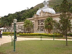
Caxambu is renowned for its spa which has twelve sources of mineral sparkling water flowing 24 hours a day and a cold-water geyser. [4]

Related Research Articles

<span class="mw-page-title-main">Goiás</span> State of Brazil

Goiás is a Brazilian state located in the Center-West region. Goiás borders the Federal District and the states of Tocantins, Bahia, Minas Gerais, Mato Grosso do Sul and Mato Grosso. The state capital is Goiânia. With 7.2 million inhabitants, Goiás is the most populous state in the Center-West and the 11th most populous in the country. It has the ninth largest economy among Brazilian federative units. In Brazil's geoeconomic division, Goiás belongs to the Centro-Sul (Center-South), being the northernmost state of the southern portion of Brazil. The state has 3.3% of the Brazilian population and is responsible for 2.7% of the Brazilian GDP.

<span class="mw-page-title-main">Aiuruoca</span> Town and municipality in the state of Minas Gerais, Brazil

Aiuruoca is a city in the Brazilian state of Minas Gerais. In 2020 its population was estimated to be 5,976.

<span class="mw-page-title-main">São Tiago</span> Town and municipality in the state of Minas Gerais, Brazil

São Tiago is a Brazilian municipality in the state of Minas Gerais. As of 2020 its population is estimated to be 10,960.

<span class="mw-page-title-main">Poços de Caldas</span> Municipality in Minas Gerais, Brazil

Poços de Caldas is a municipality in the south of Minas Gerais state, Brazil, in the microregion of the same name. Its estimated population in 2020 was 168,641 inhabitants. The city is known for its hot springs and organ transplant scandal.

<span class="mw-page-title-main">São Lourenço, Minas Gerais</span> Municipality in Southeast, Brazil

São Lourenço is a Brazilian municipality and spa town in the southern part of the state of Minas Gerais, in the Southeast of the country. It is one of the smallest Brazilian municipalities, with only 57.2 km2, and is located at an equal distance - approximately 3.5h - from two major cities, São Paulo and Rio de Janeiro.

<span class="mw-page-title-main">Tiradentes, Minas Gerais</span> Municipality in Minas Gerais, Brazil

Tiradentes is a municipality in the Brazilian state of Minas Gerais. It is located at 21°06′37″S44°12′41″W, has an area of 83.5 km², and a maximum elevation above sea level of 927 m. Tiradentes had an estimated population of 10,960, as of 2020. The original village was established in 1702 and became a city on 19 January 1718. In 1889 the city was renamed from Vila de São José do Rio das Mortes in honour of the national hero who was born nearby.

<span class="mw-page-title-main">Águas de São Pedro</span> Municipality in Southeast, Brazil

Águas de São Pedro is a Brazilian municipality in the state of São Paulo located 184 kilometres from the state capital. At only 3.61 square kilometres, it is the second-smallest Brazilian municipality in terms of area, and had an estimated population of 3,521 as of 2020. Águas de São Pedro means "Waters of Saint Peter". Its name is derived from the mineral springs in its territory and their location, which before the city's founding were part of the municipality of São Pedro.

<span class="mw-page-title-main">Esmeraldas, Minas Gerais</span> City and municipality in Minas Gerais, Brazil

Esmeraldas is a Brazilian municipality located in the state of Minas Gerais. The city belongs to the mesoregion Metropolitana de Belo Horizonte and to the microregion of Belo Horizonte. In 2020 its population was estimated to be 71,551 inhabitants.

<span class="mw-page-title-main">Cambuquira</span> Municipality in Southeast, Brazil

Cambuquira is a Brazilian municipality in the State of Minas Gerais, Brazil. It has approximately 12,812 inhabitants, and the city is part of the Circuito das Águas of Minas Gerais.

<span class="mw-page-title-main">Arantina</span> Municipality in Minas Gerais, Brazil

Arantina is a Brazilian municipality located in the state of Minas Gerais. Its population as of 2020 is estimated to be 2,787 people living in a total area of 89.382 km². The city belongs to the mesoregion of Sul and Sudoeste de Minas and to the microregion of Andrelândia.

<span class="mw-page-title-main">Baependi</span> Municipality in Minas Gerais, Brazil

Baependi is a Brazilian municipality located in the state of Minas Gerais.

<span class="mw-page-title-main">Coronel Xavier Chaves</span> Municipality in Southeast, Brazil

Coronel Xavier Chaves is a Brazilian municipality located in the state of Minas Gerais. The city belongs to the mesoregion of Campo das Vertentes and to the microregion of São João del-Rei. In 2021, the estimated population was 3,488.

<span class="mw-page-title-main">Lagoa Dourada</span> Municipality in Minas Gerais, Brazil

Lagoa Dourada is a Brazilian municipality located in the state of Minas Gerais.

<span class="mw-page-title-main">Piedade do Rio Grande</span> Municipality in Minas Gerais, Brazil

Piedade do Rio Grande is a Brazilian municipality located in the state of Minas Gerais. The city belongs to the mesoregion of Campo das Vertentes and to the microregion of Sao Joao del Rei. In 2020, the estimated population was 4,466.

<span class="mw-page-title-main">Prados, Minas Gerais</span> Municipality in Minas Gerais, Brazil

Prados is a Brazilian municipality located in the state of Minas Gerais. The city belongs to the mesoregion of Campo das Vertentes and to the microregion of Sao Joao del Rei. In 2020, the estimated population was 9,080.

<span class="mw-page-title-main">Resende Costa</span> Municipality in Minas Gerais, Brazil

Resende Costa is a Brazilian municipality located in the state of Minas Gerais. The city belongs to the mesoregion of Campo das Vertentes and to the microregion of Sao Joao del Rei. In 2020, the estimated population was 11,540.

Constantina, Rio Grande do Sul is a municipality in the state of Rio Grande do Sul, Brazil. Founded April 14, 1959. The municipality's motto is "Celeiro da Hospitalidade", meaning "Barn Hospitality".

Verdejante is a city in the state of Pernambuco, Brazil. The population in 2020, according with IBGE was 9,553 inhabitants and the total area is 476.03 km2.

<span class="mw-page-title-main">Tianguá</span> Municipality in Nordeste, Brazil

Tianguá is a municipality in the state of Ceará in the Northeast region of Brazil.

<span class="mw-page-title-main">Nova Serrana</span> Municipality in Southeast, Brazil

Nova Serrana is a municipality in the state of Minas Gerais in the Southeast region of Brazil.

References

  1. "Área territorial oficial". Resolução da Presidência do IBGE de n° 5 (R.PR-5/02). 10 October 2002. Retrieved 5 December 2010.
  2. "IBGE Caxambu". IBGE . Retrieved 14 March 2022.
  3. "Archived copy" (PDF). United Nations Development Programme (UNDP). Archived from the original (PDF) on July 8, 2014. Retrieved August 1, 2013.{{cite web}}: CS1 maint: archived copy as title (link)
  4. Bonotto, Daniel Marcos (2016). "Hydrogeochemical study of spas groundwaters from southeast Brazil". Journal of Geochemical Exploration. Elsevier BV. 169: 60–72. doi:10.1016/j.gexplo.2016.07.016. hdl: 11449/173240 .

21°59′S44°55′W / 21.983°S 44.917°W / -21.983; -44.917