Aguanil

Last updated
Location of Aguanil MinasGerais Municip Aguanil.svg
Location of Aguanil

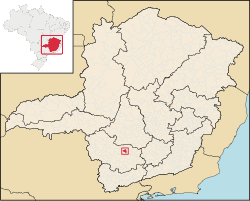
Aguanil is a municipality in the Brazilian state of Minas Gerais. It was founded on 30 December 1962 and, in 2020, its population was estimated to be 4,522. [1]

Related Research Articles

<span class="mw-page-title-main">Wausaukee, Wisconsin</span> Village in Wisconsin, United States

Wausaukee is a village in Marinette County, Wisconsin, in the United States. The population was 596 at the 2020 census. The village is part of the Marinette, WI–MI Micropolitan Statistical Area.

The Captaincy of São Vicente (1534–1709) was a land grant and colonial administration in the far southern part of the colonial Portuguese Empire in Colonial Brazil.

<span class="mw-page-title-main">Nimrod Glacier</span> Glacier in Antarctica

The Nimrod Glacier is a major glacier about 85 nautical miles long, flowing from the polar plateau in a northerly direction through the Transantarctic Mountains into the Ross Ice Shelf, Antarctica.

<span class="mw-page-title-main">Alfenas</span> City and municipality in the southern part of the Brazilian state of Minas Gerais

Alfenas is a municipality in the southern part of the Brazilian state of Minas Gerais. In 2020 its population was 80,494 and the area of the municipality is 849 km2. The elevation is 888m. It is served by highways MG 179, BR 491 and BR 369. The distance to the state capital of Belo Horizonte is 335 km and the distance to São Paulo is 300 km. The slogan for the city is "Alfenas, the gateway to the sea of Minas", in reference to nearby Lake Furnas.

<span class="mw-page-title-main">Itanhandu</span> Place in Minas Gerais, Brazil

Itanhandu is a city in the south of Minas Gerais, Brazil with a population of 15,423 and a total area of 143,9 km².

<span class="mw-page-title-main">Dom Joaquim</span> Human settlement in Brazil

Dom Joaquim is a Brazilian municipality in the state of Minas Gerais. The city belongs to the mesoregion of Belo Horizonte and to the microregion of Conceição do Mato Dentro. As of 2020, the estimated population was 4,451.

<span class="mw-page-title-main">Cândido Godói</span> Municipality in South, Brazil

Cândido Godói is a municipality of 6,151 inhabitants in the state of Rio Grande do Sul, Brazil near the Argentine border, famous for the high number of twins born there. The twin phenomenon is centered in Linha São Pedro, a small settlement in the city of Cândido Godói, in an ethnically homogeneous population of German descent.

Chiapetta is a municipality in the state of Rio Grande do Sul, Brazil. As of 2020, the estimated population was 3,719.

<span class="mw-page-title-main">Sananduva</span> Municipality in South, Brazil

Sananduva is a municipality in the state of Rio Grande do Sul, Brazil. As of 2020, the estimated population was 16,328.

<span class="mw-page-title-main">Pains, Minas Gerais</span> Town and municipality in the state of Minas Gerais, Brazil

Pains is a Brazilian municipality located in the center of the state of Minas Gerais. Its population as of 2020 was 8,296 people living in a total area of 418 km². The city belongs to the meso-region of Oeste de Minas and to the micro-region of Formiga. It became a municipality in 1943.

<span class="mw-page-title-main">Lavras da Mangabeira</span> Municipality in Nordeste, Brazil

Lavras da MangabeiraPortuguese pronunciation:[ˈlavɾɐzdamɐ̃gaˈbejɾɐ] is a municipality in the state of Ceará in the Northeast region of Brazil.

Perdigão, Minas Gerais is a municipality in the state of Minas Gerais in the Southeast region of Brazil.

<span class="mw-page-title-main">Macará Canton</span> Canton in Loja Province, Ecuador

Macará Canton is a canton of Ecuador, located in the Loja Province. Its capital is the town of Macará. Its population at the 2001 census was 18,350.

Planet Heights is a series of summits running along an ice-free ridge, extending 24 nautical miles (44 km) in a north-south direction between the southernmost extremity of the LeMay Range and George VI Sound in the east part of Alexander Island, Antarctica. Many landforms and nearby features are named in association with this mountain range; some of these include landforms named after astronomers, satellites, planets and other things related to astrology and astrophysics. The mountain range was first mapped from air photos taken by the Ronne Antarctic Research Expedition (RARE), 1947–48, by Searle of the Falkland Islands Dependencies Survey (FIDS) in 1960. Named by the United Kingdom Antarctic Place-Names Committee (UK-APC) from association with the nearby glaciers named for planets of the Solar System. The only planet that is not featured in any of these glaciers is the planet Earth, as there are no glaciers named "Earth Glacier" and this glacier does not exist.

The Mackin Table is an ice-topped, wedge-shaped plateau, about 20 nautical miles long, standing just north of Patuxent Ice Stream in the Patuxent Range of the Pensacola Mountains, Antarctica.

Starshot Glacier is a glacier 50 nautical miles (90 km) long that flows through the Churchill Mountains to enter the Ross Ice Shelf in Antarctica.

<span class="mw-page-title-main">Mundrabilla (meteorite)</span> Meteorite found in Western Australia

The Mundrabilla meteorite is an iron meteorite found in 1911 in Australia, one of the largest meteorites found, with a total known weight of 22 tonnes and the main mass accounting for 12.4 tonnes.

Ro-35 was an Imperial Japanese Navy Kaichū type submarine, the lead unit of the K6 sub-class. Completed and commissioned in March 1943, she served in World War II and was sunk during her first war patrol in August 1943.

References

  1. "Aguanil" (in Portuguese). Brasília, Brazil: Instituto Brasileiro de Geografia e Estatística (Brazilian Institute of Geography and Statistics). 2024. Retrieved 2024-02-01.

20°57′S45°23′W / 20.950°S 45.383°W / -20.950; -45.383