
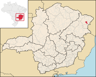
Jequitinhonha is a Brazilian municipality located in the northeast of the state of Minas Gerais.
Jequitinhonha is a Brazilian municipality located in the northeast of the state of Minas Gerais.
The population as of 2020 [update] was estimated to be 25,474 people living in a total area of 3,518 km². [1] The city belongs to the mesoregion of Jequitinhonha and to the microregion of Almenara. [2]
Jequitinhonha is located on the river of the same name. The elevation is 223 meters. It became a municipality in 1911. The distance to the state capital, Belo Horizonte is 582 km.
Neighboring municipalities are: Joaíma, Felisburgo, Rubim, Almenara, Pedra Azul and Sao Pedro do Jequitinhonha.
The municipality contains most of the 50,890 hectares (125,800 acres) Mata Escura Biological Reserve, created in 2003. [3]
The main economic activities are cattle raising and the cultivation of coffee, sugarcane and corn. The GDP in 2006 was R$66,471,000. There were 02 banking agencies as of 2007 [update] . In the same year there were 699 automobiles, which was a ratio of one automobile for every 30 people. In the rural area there were 1,905 producers of which only 51 had tractors. There were 88,000 head of cattle in 2006. [4] This municipality is isolated from major population centers and suffers from drought and poor soils.

Almenara, is a municipality in the northeast of the Brazilian state of Minas Gerais. Situated on the Jequitinhonha River it is the largest city in that river valley. Its 2020 population was estimated at 42,143 and the municipal area was 2,301 km².

Virgem da Lapa is a Brazilian municipality located in the northeast of the state of Minas Gerais. Its population as of 2020 was estimated to be 13,740 people living in a total area of 871 km2 (336 sq mi). The city belongs to the mesoregion of Jequitinhonha and to the microregion of Araçuaí. It became a municipality in 1948.

Araçuaí is a Brazilian municipality located in the northeast of the state of Minas Gerais in the Jequitinhonha River valley. The Araçuaí River, a tributary of the Jequitinhonha, flows through it. Its population as of 2020 was estimated to be 36,712 people living in a total area of 2,235 km2. The city belongs to the mesoregion of Jequitinhonha and to the microregion of Araçuaí. The city is the seat of the Roman Catholic Diocese of Araçuaí. The elevation of the municipal seat is 307 meters. It became a municipality in 1870.

Bandeira is a Brazilian municipality located in the state of Minas Gerais. Its population as of 2020 was estimated to be 4,766 people living in a total area of 484 km². The city belongs to the mesoregion of Jequitinhonha and to the microregion of Almenara.

Capelinha is a Brazilian municipality located in the north-center of the state of Minas Gerais. Its population as of 2020 was 38,057 living in a total area of 966 km². The city belongs to the statistical mesoregion of Jequitinhonha and to the statistical microregion of Capelinha. It became a municipality in 1913.

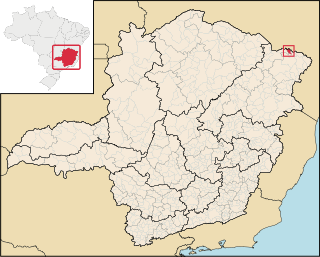
Divisópolis is a Brazilian municipality located in the northeast of the state of Minas Gerais.
Felisburgo is a Brazilian municipality located in the northeast of the state of Minas Gerais.

Joaíma is a Brazilian municipality located in the northeast of the state of Minas Gerais.

Jordânia is a Brazilian municipality located in the northeast of the state of Minas Gerais. The city belongs to the mesoregion of Jequitinhonha and to the microregion of Almenara. As of 2020 the population was 10,842 in a total area of 549 km².
Mata Verde is a Brazilian municipality located in the state of Minas Gerais. As of 2020 the population was 8,644 and the area was 230 km2 (89 sq mi). The elevation is 865 m (2,838 ft).

Monte Formoso is a Brazilian municipality located in the northeast of the state of Minas Gerais. The city belongs to the IBGE statistical mesoregion of Jequitinhonha and to the microregion of Almenara. As of 2020 the population was 4,923 in an area of 384 km². The elevation was 651 meters.

Rubim is a municipality in the northeast of the Brazilian state of Minas Gerais. Its population in 2020 was 10,256 inhabitants in a total area of 969 km².
Caraí is a Brazilian municipality located in the northeast of the state of Minas Gerais. Its population as of 2020 was estimated to be 23,780 people living in a total area of 1,240 km². The city belongs to the mesoregion of Jequitinhonha and to the microregion of Araçuaí. The elevation of the municipal seat is 750 meters. It became a municipality in 1948.

Coronel Murta is a Brazilian municipality located in the northeast of the state of Minas Gerais. Its population as of 2020 was estimated to be 9,215 people living in a total area of 813 km². The city belongs to the mesoregion of Jequitinhonha and to the microregion of Araçuaí. It became a municipality in 1953.

Padre Paraíso is a Brazilian municipality located in the northeast of the state of Minas Gerais. Its population as of 2020 was estimated to be 20,252 people living in a total area of 543 km². The city belongs to the mesoregion of Jequitinhonha and to the microregion of Araçuaí. It became a municipality in 1962.

Cristália is a Brazilian municipality located in the north of the state of Minas Gerais. In 2020 the population was 5,982 in a total area of 841 km2. The elevation is 728 meters. It became a municipality in 1962.

Itacambira is a Brazilian municipality located in the north of the state of Minas Gerais. In 2020 the population was 5,417 in a total area of 1,788 km². It became a municipality in 1962.

Josenópolis is a Brazilian municipality located in the north of the state of Minas Gerais. In 2020 the population was 4,889 in a total area of 536 km². It became a municipality in 1997.

Padre Carvalho is a Brazilian municipality located in the north of the state of Minas Gerais. In 2020 the population was 6,423 in a total area of 450 km². It became a municipality in 1997.

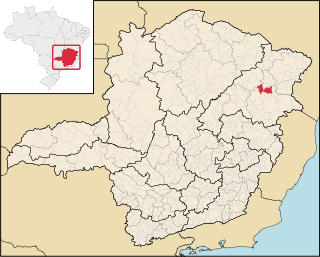
Senador Modestino Gonçalves is a Brazilian municipality in the state of Minas Gerais.
Capital: Belo Horizonte | |||||||||||||||||||||||||
|  | ||||||||||||||||||||||||
|
| |||||||||||||||||||||||||
| |||||||||||||||||||||||||
| |||||||||||||||||||||||||
| |||||||||||||||||||||||||
| |||||||||||||||||||||||||
| |||||||||||||||||||||||||
| |||||||||||||||||||||||||
| |||||||||||||||||||||||||
| |||||||||||||||||||||||||
| |||||||||||||||||||||||||