Pouso Alto

Last updated
Pouso Alto
Municipality
Panoramicapousoalto2.jpg
Bandeira de Pouso Alto.jpg
Flag
Brasaopousoalto.jpg
Seal
Coordinates: 22°11′37″S44°58′21″W / 22.19361°S 44.97250°W / -22.19361; -44.97250
CountryFlag of Brazil.svg  Brazil
Region Southeast
State Minas Gerais
MesoregionSul/Sudoeste de Minas
Elevation
884 m (2,900 ft)
Time zone UTC -3

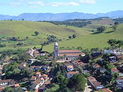
Pouso Alto (translation: High Landing) is a municipality in the state of Minas Gerais in the Southeast region of Brazil. [1] [2] [3] [4]

The municipality contains 4.39% of the 22,917 hectares (56,630 acres) Serra do Papagaio State Park, created in 1998. [5]

See also

Related Research Articles

Rio Manso Municipality in Southeast, Brazil

Rio Manso is a municipality in the state of Minas Gerais in the Southeast region of Brazil.

Cachoeira da Prata is a municipality in the state of Minas Gerais in the Southeast region of Brazil.

Fortuna de Minas is a municipality in the state of Minas Gerais in the Southeast region of Brazil.

Funilândia is a municipality in the state of Minas Gerais in the Southeast region of Brazil.

Jequitibá is a municipality in the state of Minas Gerais in the Southeast region of Brazil.

Maravilhas Municipality in Southeast, Brazil

Maravilhas is a municipality in the state of Minas Gerais in the Southeast region of Brazil.

Pequi, Minas Gerais Municipality in Southeast, Brazil

Pequi, Minas Gerais is a municipality in the state of Minas Gerais in the Southeast region of Brazil.

Prudente de Morais, Minas Gerais is a municipality in the state of Minas Gerais in the Southeast region of Brazil.

Igaratinga is a municipality in the state of Minas Gerais in the Southeast region of Brazil.

Ibituruna Municipality in Southeast, Brazil

Ibituruna is a municipality in the state of Minas Gerais in the Southeast region of Brazil.

Passa Tempo is a municipality in the state of Minas Gerais in the Southeast region of Brazil.

Fama, Minas Gerais Municipality in Southeast, Brazil

Fama, Minas Gerais is a municipality in the state of Minas Gerais in the Southeast region of Brazil.

Carvalhos, Minas Gerais Municipality in Southeast, Brazil

Carvalhos, Minas Gerais is a municipality in the state of Minas Gerais in the Southeast region of Brazil.

Cruzília Municipality in Southeast, Brazil

Cruzília, Minas Gerais is a municipality in the state of Minas Gerais in the Southeast region of Brazil.

São Vicente de Minas Municipality in Southeast, Brazil

São Vicente de Minas is a municipality in the state of Minas Gerais in the Southeast region of Brazil.

Sapucaí-Mirim Municipality in Southeast, Brazil

Sapucaí-Mirim is a municipality in the state of Minas Gerais in the Southeast region of Brazil.

Toledo, Minas Gerais is a municipality in the state of Minas Gerais in the Southeast region of Brazil.

Cachoeira de Minas Municipality in Southeast, Brazil

Cachoeira de Minas is a municipality in the state of Minas Gerais in the Southeast region of Brazil.

Soledade de Minas is a municipality in the state of Minas Gerais in the Southeast region of Brazil.

São José do Divino, Minas Gerais is a municipality in the state of Minas Gerais in the Southeast region of Brazil.

References

  1. "Divisão Territorial do Brasil" (in Portuguese). Divisão Territorial do Brasil e Limites Territoriais, Instituto Brasileiro de Geografia e Estatística (IBGE). July 1, 2008. Retrieved December 17, 2009.
  2. "Estimativas da população para 1º de julho de 2009" (PDF) (in Portuguese). Estimativas de População, Instituto Brasileiro de Geografia e Estatística (IBGE). August 14, 2009. Retrieved December 17, 2009.
  3. "Ranking decrescente do IDH-M dos municípios do Brasil" (in Portuguese). Atlas do Desenvolvimento Humano, Programa das Nações Unidas para o Desenvolvimento (PNUD). 2000. Archived from the original on October 3, 2009. Retrieved December 17, 2009.
  4. "Produto Interno Bruto dos Municípios 2002-2005" (PDF) (in Portuguese). Instituto Brasileiro de Geografia e Estatística (IBGE). December 19, 2007. Retrieved December 17, 2009.
  5. PES da Serra do Papagaio (in Portuguese), ISA: Instituto Socioambiental, retrieved 2016-09-27

Coordinates: 22°11′38″S44°58′22″W / 22.1939°S 44.9728°W / -22.1939; -44.9728