Bom Jardim de Minas

Last updated
Bom Jardim de Minas
Municipality
The Municipality of Bom Jardim de Minas
Bomjardim.jpg
View of Bom Jardim de Minas
Bandeira de Bom Jardim de Minas.png
Brasao de Bom Jardim de Minas.png
Nickname: 
BJM
Motto: 
Omnis gloriam Dei
MinasGerais Municip BomJardimdeMinas.svg
Location in Brazil
Coordinates: 21°56′15″S41°00′58″W / 21.93750°S 41.01611°W / -21.93750; -41.01611
Country Brazil
Region Southeast
State Minas Gerais
Incorporated December 17, 1937
Government
   Mayor José Francisco Matos e Silva, PSD
Area
  Total395 km2 (152.5 sq mi)
Elevation
1,119 m (3,671 ft)
Population
 (2020 [1] )
  Total6,459
  Density15/km2 (10/sq mi)
Time zone UTC−3 (BRT)
Postal Code
37310-000
Area code +55 32
Website Bom Jardim de Minas, Minas Gerais

Bom Jardim de Minas is a city of the state of Minas Gerais, Brazil.

Contents

The name means Good Garden of Minas (Gerais).

It is situated in the southern part of Minas Gerais and in the middle of the Mantiqueira Mountains, at 1,200 meters high, which gives the city a mild climate.

The only paved road that reaches Bom Jardim de Minas is the BR-267, which connects the city to the southern part of the State of Minas Gerais and the region of Juiz de Fora.

Population: 6,459 inhabitants.

It was founded in 1770 with the formation of a farm land in current city. When it came near the farm houses, became a parish and then the district with the installation of the chapel on May 2, 1856. And finally, in 1938, the district was upgrade to city, with two districts, headquarters and Taboão.

Currently, the city has been increasing in the festivities such as Carnival. An agricultural exhibition in May, and a feast in honour of Jesus Christ in August. Along with the natural attractions of waterfalls and mountain scenery these contribute to the tourism industry of the city.

History

In 1770 Arriaga Manoel de Oliveira, accompanied by his wife and six children, founded the Colony of Campo Vermelho near the current city. They were attacked by a tribe of Indians who inhabited the region and during the attack one of his sons was killed. Manoel Arriaga, very saddened by the fact, turned away from the colony and settled on the banks of the Milho Branco stream where he set up a farm which in time became the city. [2]

Years later, Manoel Arriaga was visited by the illustrious Captain Antonio Correia de Lacerda and his family. He joined with Manoel Arriaga in expanding the farm and beginning the cultivation of land on a large scale. [2]

At the request of Captain Lacerda the chapel of Bom Jardim, today the old parish church, was erected in the village centre. [2]

Some years later, with the union of families Arriaga and Lacerda, the farm received the name "Fazenda do Bom Jardim". The origin of the name was due to a well maintained garden near the farmhouse.

In 1856 the village of Senhor Bom Jesus do Bom Jardim was instituted by provincial Law No. 761 of May 2 as belonging to the municipality of Turvo. [2]

The effect of State Law No. 843 of 7 September 1923 was to rename the District to "Bom Jardim" but continuing to belong to the municipality of Turvo. Soon after, under State Law No. 1160, the City of Turvo had its name changed to Andrelândia. The Municipality with the name of Bom Jardim, was created by Decree-State Law No. 148 of December 17, 1938. It consisted of two districts: the headquarters, originally part of the Municipality of Andrelândia, and Taboão from the city of Rio Preto. By Decree-State Law No. 1058 of 31 December 1943 the City of Bom Jardim changed its name to Bom Jardim de Minas and included the new district of Arantina, split off from the District Headquarters. In 1962 Arantina was emancipated and Bom Jardim de Minas reverted to having the two districts of Headquarters and Taboão. [2]

Geography

The area of the municipality is 395 square kilometers (153 sq mi), representing 0.07% of the state, the region 0.045% and 0.005% of the entire Brazilian territory. Located on the banks of the Rio Grande in the southern region of the state of Minas Gerais, and the Serra da Mantiqueira.

It is located 281 kilometers (175 miles) from Belo Horizonte, the state capital. The relief of the municipality consists of plateaus, with an average elevation of 1,100 meters, however, this average decreases toward the Rio Grande, to form the lowland rain that is circumvented by the "sea of hills and mountains," with higher topographic level. The highest point is the Serra da Bandeira in Taboão at elevation of 1733 meters.

The region consists of many Taboão high elevation mountains with many water springs, which means that there are several waterfalls in the region. The headwaters of the Rio do Peixe, one of the largest rivers in the region, located in the hills district Taboão.

Climate

The city has mesothermal highland tropical climate, with cold and dry winter rains and higher, taking into account the situation of latitude and elevation ranging from 990 m to 1733 m. According to regional averages, the winter is hardly unpleasant unless one or the other day, the coldest month, July, has averaged approximately 55 °F and 61 °F, daily maximum of 71 °F and 73 °F and minimum of 41 °F to 50 °F and may reach even with minimum absolute in Celsius Scale up to 0 °C (32 °C), and may even gear.

Mayors of Bom Jardim de Minas

This list composes all the mayors of the city of Bom Jardim de Minas, with their respective years since the birth of the city in 1938.

Caption text
Term IndexMayor NameTermspan
1Americo Ferreira Pena1939 - 1946
2Joaquim A. Souza Correia1946 - 1948
3Assis Rodrigues da Silva1948 - 1951
4Geraldo Andrade1951 - 1955
5José Landim (1st term)1955 - 1959
6Octaviano Nardy Ribeiro1959 - 1963
7José Landim (2nd term)1963 - 1967
8Orlando Altomare de Carvalho1967 - 1971
9José Bougleux de Andrade1971 - 1972
10Itacy Bougleux de Andrade1972 - 1973
11Dimas Abbud1973 - 1977
12Octaviano Nardy Ribeiro (2nd term)1977 - 1982
13Sebastiao Delgado de Almeida1983 - 1988
14Manoel Rodrigues1989 - 1992
15Valtencir de Paula Nunes (1st term)1993 - 1996
16Genivaldo Marques de Paula1997 - 2000
17Valtencir de Paula Nunes (2nd term)2001 - 2024
18Carlos Roberto Marques2005 - 2008
19Joaquim Laercio Rodrigues (1st term)2009 - 2012
20Joaquim Laercio Rodrigues (2nd term)2013 - 2016
21Sérgio Martins2017 - 2020
22Joaquim Laercio Rodrigues (3rd term)2021 - 2023
23José Francisco Matos e Silva2023

Coordinates: 21°57′S44°11′W / 21.950°S 44.183°W / -21.950; -44.183

Related Research Articles

<span class="mw-page-title-main">Santos Dumont, Minas Gerais</span> Municipality in Southeast, Brazil

Santos Dumont is a municipality in southern Minas Gerais state, Brazil. The population (2020) is estimated to be 46,421 and the total area of the municipality is 639.1 km2 (246.8 sq mi). It lies at an elevation of 839 m (2,753 ft) just off the main interstate highway, BR040, between the urban centers of Barbacena (north) and Juiz de Fora (south). It is 240 km (150 mi) from the state capital, Belo Horizonte, and 220 km (140 mi) from Rio de Janeiro. It became a city in 1889.

<span class="mw-page-title-main">Cachoeira Paulista</span> Municipality in Southeast Brazil, Brazil

Cachoeira Paulista is a municipality in the state of São Paulo in Brazil. It is part of the Metropolitan Region of Vale do Paraíba e Litoral Norte, in the Guaratinguetá Microregion.

<span class="mw-page-title-main">Luz, Minas Gerais</span> Municipality in Southeast, Brazil

Luz is a Brazilian municipality located in the West part of the state of Minas Gerais. Luz is located between the city of Araxá and the capital city of the state of Minas Gerais, Belo Horizonte. The population is 18,257 in an area of 1172 km². The city belongs to the Central Mineira region and to the micro-region of Bom Despacho. It became a municipality in 1923.

<span class="mw-page-title-main">Queluz, São Paulo</span> Municipality in Southeast, Brazil

Queluz is a municipality in the state of São Paulo in Brazil. It is part of the Metropolitan Region of Vale do Paraíba e Litoral Norte.

<span class="mw-page-title-main">Andrelândia</span> Municipality in the state of Minas Gerais, Brazil

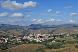
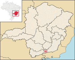
Andrelândia is a Brazilian municipality in the state of Minas Gerais that is located in the Mesoregion of South and Southwest of Minas and hosts the Microregion of Andrelândia. It is 300 km away from the state capital, Belo Horizonte and occupies an area of approximately 1 005 km2. In 2014 its population was estimated at 12 507 inhabitants, being the 296th most populous municipality in the state of Minas Gerais and the second of its microregion.

<span class="mw-page-title-main">Viçosa, Minas Gerais</span> Municipality in Southeast, Brazil

Viçosa is a Brazilian municipality in the state of Minas Gerais. Its population as of 2021 was estimated at 79,910 inhabitants.

<span class="mw-page-title-main">Itatiaia</span> Municipality in Southeast, Brazil

Itatiaia is a Brazilian municipality in the state of Rio de Janeiro. With a 2021 population estimate of 32,312, it is the 1,097th-most populous municipality in Brazil. Located in the Mantiqueira mountain range and on the border of the states of Rio de Janeiro and Minais Gerais, it covers an area of 241,035 km2 (93,064 sq mi).

<span class="mw-page-title-main">Barbacena</span> Municipality in Minas Gerais, Brazil

Barbacena is a municipality in the state of Minas Gerais, Brazil. As of 2020, the municipality had 138,204 inhabitants. The total area of the municipality is 788 km2 (304 sq mi).

<span class="mw-page-title-main">Lima Duarte, Minas Gerais</span> Municipality in Southeast, Brazil

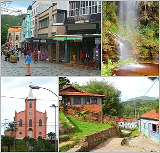
Lima Duarte is a municipality in the state of Minas Gerais, Brazil. It has a population of 16,724 inhabitants (2020) and a total area of 848 square kilometres (327 sq mi) and lies at an elevation of 860 metres (2,822 ft) in the foothills of the Mantiqueira Mountains. It was given city status in 1881.

<span class="mw-page-title-main">Leandro Ferreira</span>

Leandro Ferreira is a Brazilian municipality located in the center of the state of Minas Gerais. Its population as of 2020 was 3,226 people living in a total area of 355 km2 (137 sq mi). The city belongs to the meso-region of Central Mineira and to the micro-region of Bom Despacho. It became a municipality in 1963.

<span class="mw-page-title-main">Mantiqueira Mountains</span> Mountain range in Brazil

The Mantiqueira Mountains are a mountain range in Southeastern Brazil, with parts in the states of São Paulo, Minas Gerais and Rio de Janeiro. It rises abruptly from the northwestern bank of the Paraíba do Sul River and extends northeastward for approximately 320 km (200 mi), reaching a height of 2,798 m (9,180 ft) at Pedra da Mina. The mountains, which eventually merge with the Serra do Espinhaço, were originally forest-covered, except for the peaks that rise above the tree line. They provide charcoal and pasture for cattle; on the lower slopes there are several health and tourist resorts, such as Campos do Jordão, Brazil's highest city. The name Mantiqueira derives from a Tupi word meaning "mountains that cry", denoting the large number of springs and streams found there.

<span class="mw-page-title-main">Bom Jardim de Goiás</span> Municipality in Central-West, Brazil

Bom Jardim de Goiás is a municipality in western Goiás state, Brazil. The population was 8,869 (2020) in a total area of 1,557 km². Bom Jardim is a large producer of cattle.

<span class="mw-page-title-main">Espera Feliz</span> Brazilian municipality in the state of Minas Gerais

Espera Feliz is a municipality in southeastern Minas Gerais state, Brazil. The altitude is 2,430 m above sea level. Located at 20°39′00″S41°54′25″W, its neighboring cities are Caiana to the south, Dores do Rio Preto to the east, Divino to the west, Alto Caparaó and Caparaó to the north and Carangola to the southwest.

<span class="mw-page-title-main">Oliveira, Minas Gerais</span> Municipality in Southeast, Brazil

Oliveira is a Brazilian municipality in the state of Minas Gerais. It is located at latitude 20º41'47" south and longitude 44º49'38" west, at an altitude of 982 metres. It is located 165 kilometres at southwest from Belo Horizonte. Its estimated population was 41,181 according to the latest IBGE census.

<span class="mw-page-title-main">Arantina</span> Municipality in Minas Gerais, Brazil

Arantina is a Brazilian municipality located in the state of Minas Gerais. Its population as of 2020 is estimated to be 2,787 people living in a total area of 89.382 km². The city belongs to the mesoregion of Sul and Sudoeste de Minas and to the microregion of Andrelândia.

<span class="mw-page-title-main">Baependi</span> Municipality in Minas Gerais, Brazil

Baependi is a Brazilian municipality located in the state of Minas Gerais.

<span class="mw-page-title-main">Guaxupé</span>

Guaxupé is a Brazilian municipality located in the southwest of the state of Minas Gerais. Its estimated population in 2020 was 52,078 inhabitants living in a total area of 286 km². The city belongs to the meso-region of Sul e Sudoeste de Minas and to the micro-region of São Sebastião do Paraíso. It became a municipality in 1837.

Senador Amaral is the second highest city in Brazil (1,505 m [4,938 ft]), reaching near 1,620 m (5,310 ft) in some parts in the northern areas, nearly the Ponte Segura district, the highest point is an unnamed mount in Bom Repouso border at approximately 1,660 m (5,450 ft) above sea level. It is located in the Mantiqueira Mountains, south of Minas Gerais state. It is a small city, with a population of 5,361 inhabitants and approximately 2980 people living in the urban area. There was no asphalt or mobile phone signal in the municipality before 2007. Only Cambuí access, MG-295 is asphalted.

<span class="mw-page-title-main">Marmelópolis</span> Municipality in Southeast, Brazil

Marmelópolis is a municipality in the state of Minas Gerais in the Southeast region of Brazil.

Mantena is a municipality in the state of Minas Gerais in the Southeast region o Brazil.

References

  1. IBGE 2020
  2. 1 2 3 4 5 Driven by: FERREIRA, Jurandir Pires. Text by: PEREIRA, Maria Auxiliadora Peres; & DIAS, Miguel. Enciclopédia dos Municípios Brasileiros. Rio de Janeiro: IBGE, 1957.