Catimbau National Park

Last updated
Catimbau National Park
Parque Nacional do Catimbau
Catimbau 26 rec.jpg
Catimbau Valley- the 2nd largest Brazilian Archeological site]
Relief Map of Brazil.jpg
Red pog.svg
Map of Brazil
LocationNear Buíque in the state of Pernambuco, Brazil
Nearest city Tupanatinga, Pernambuco
Coordinates 8°37′00″S37°09′00″W / 8.61667°S 37.15°W / -8.61667; -37.15
Area62,300 hectares (154,000 acres)
Designation National park
Established2002
Governing body ICMBio

The Catimbau National Park (Portuguese : Parque Nacional do Catimbau) is a national park in the state of Pernambuco, Brazil. It protects a semi-arid area of caatinga with sandstone caverns and caves in which prehistoric art has been found.

Contents

Location

Vale do Catimbau National Park is divided between the municipalities of Buíque (17.6%), Ibimirim (40.41%) and Tupanatinga (41.99%) in Pernambuco. It has an area of 62,300 hectares (154,000 acres). [1] It lies to the south of highway BR-110 and the town of Cruzeiro do Nordesta. It adjoins the Kapinawá Indigenous Territory to the south. [2]

The Catimbau Valley (Portuguese : Vale do Catimbau) is Brazil's 2nd largest archaeological site. Among its natural attractions there are beautiful canyons, over 2,000 caves, and 28 registered areas with pre-historical cave paintings. One of the sites, Pedra da Concha (Shell Rock), displays cave art dating at least 6,000 years ago. [3] The park has been designated a national archaeological heritage site by the National Institute of Historic and Artistic Heritage (IPHAN). [4]

Environment

The park is in the caatinga biome. [5] It is in the semi-arid region of Pernambuco in the transition between the agreste and sertão vegetation zones, which makes a mosaic of landscapes with high biodiversity. The sandstone walls and the Tacaratu Formation have been carved by wind and rain into different shapes with shades of color. There are indications that the region has considerable speleological potential. [6]

The extreme north of the park has well-preserved caatinga, and is inaccessible, with the eastern portion better preserved than the west, with wetlands, cliffs and the main ecotourism trails. In the west there are small family farms with some irrigation, and some indigenous communities that lost land when the park was created. [4]

History

The Vale do Catimbau National Park was created on 13 December 2002 with an area of 62,294.14 hectares (153,932.2 acres). It is administered by the Chico Mendes Institute for Biodiversity Conservation (ICMBio). [5] It is classed as IUCN protected area category II (national park), and has as its objectives preservation of natural ecosystems of great ecological relevance and scenic beauty, enabling the conduct of scientific research and the development of educational activities and environmental interpretation, recreation in contact with nature and ecological tourism. [7]

The park encourages environmental research by federal higher educational institutions such as Federal University of Pernambuco, Federal Rural University of Pernambuco and Federal Institute of Pernambuco into the interaction between fauna and flora, the geology and the archaeology. [4] The park became part of the Caatinga Ecological Corridor, created in May 2006. [8]

Related Research Articles

<span class="mw-page-title-main">Pico da Neblina National Park</span>

Pico da Neblina National Park is a national park in the state of Amazonas in the north of Brazil, bordering on Venezuela. It overlaps with several indigenous territories, which creates tensions over land use, as does the military presence due to the border location. The park includes lowlands around the Rio Negro, partly flooded, and mountains that include the highest peak in Brazil, after which the park is named. The wide variety of physical environments supports great biodiversity, including several endangered species.

<span class="mw-page-title-main">Cabo Orange National Park</span>

The Cabo Orange National Park is a National park located in Amapá state in the north of Brazil, near the border between Brazil and French Guiana.

<span class="mw-page-title-main">Fernando de Noronha Marine National Park</span> National park in the state of Pernambuco, Brazil

Fernando de Noronha Marine National Park is a national park in the state of Pernambuco, Brazil.

Pacaás Novos National Park is a national park in the state of Rondônia, Brazil. The park contains a mountain range by the same name.

<span class="mw-page-title-main">Pantanal Matogrossense National Park</span>

The Pantanal Matogrossense National Park is a national park in the state of Mato Grosso at the border to Mato Grosso do Sul, Brazil.

<span class="mw-page-title-main">Serra do Pardo National Park</span>

The Serra do Pardo National Park is a National park in the state of Pará, Brazil.

<span class="mw-page-title-main">Viruá National Park</span>

Viruá National Park is a national park in the state of Roraima, Brazil. It protects an area with very infertile sandy soil, periodically flooded, that has no economic value but has exceptionally high biodiversity.

Serra Negra Biological Reserve is a Biological reserve in the state of Pernambuco, Brazil.

<span class="mw-page-title-main">Anavilhanas National Park</span> National park in Brazil

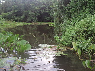
Anavilhanas National Park is a national park that encompasses a huge river archipelago in the Rio Negro in the state of Amazonas, Brazil. It is part of a World Heritage Site.

<span class="mw-page-title-main">Furna Feia National Park</span>

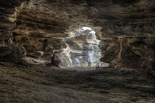
The Furna Feia National Park is a national park in the state of Rio Grande do Norte, Brazil that contains a large cave system.

<span class="mw-page-title-main">Rio Novo National Park</span> National park in Pará, Brazil

Rio Novo National Park is a national park in the state of Pará, Brazil.

<span class="mw-page-title-main">Mapinguari National Park</span> National Park in Rondônia and Amazonas, Brazil

Mapinguari National Park is a national park in the states of Rondônia and Amazonas, Brazil. It covers a large area of Amazon rainforest. The boundaries have been adjusted several times.

<span class="mw-page-title-main">Campos Amazônicos National Park</span> National park in Brazil

The Campos Amazônicos National Park is a National park in the states of Rondônia, Amazonas and Mato Grosso, Brazil.

<span class="mw-page-title-main">Descobrimento National Park</span> National park in Bahia, Brazil

The Descobrimento National Park is a national park in the state of Bahia, Brazil.

<span class="mw-page-title-main">Serra das Confusões National Park</span>

The Serra das Confusões National Park is a national park in the state of Piauí, Brazil.

<span class="mw-page-title-main">Serra do Gandarela National Park</span> National park in Minas Gerais, Brazil

Serra do Gandarela National Park is a national park in the state of Minas Gerais, Brazil. It protects a mountainous region holding a remnant of Atlantic Forest that is an important source of water for the city of Belo Horizonte.

Acari National Park is a national park in the state of Amazonas, Brazil.

The Caatinga Ecological Corridor is an ecological corridor in the caatinga biome of northeast Brazil.

The Maurício Dantas Private Natural Heritage Ecological Reserve is a private natural heritage reserve in the state of Pernambuco, Brazil. It protects an area of dry caatinga vegetation. It was created on 12 September 1997.

<span class="mw-page-title-main">Castanhão Ecological Station</span> Ecological station in Brazil

The Castanhão Ecological Station is an ecological station (ESEC) in the state of Ceará, Brazil. It protects an area of caatinga vegetation adapted to arid conditions to the south of the Castanhão Dam.

References

  1. PARNA do Catimbau – ISA, Informações gerais.
  2. PARNA do Catimbau – ISA, Informações gerais (mapa).
  3. Scoones 2006, pp. 8ff.
  4. 1 2 3 Parque Nacional do Catimbau – Fundação Joaquim Nabuco.
  5. 1 2 Parna do Catimbau – ICMBio.
  6. PARNA do Catimbau – ISA, Características.
  7. Unidade de Conservação ... MMA.
  8. Ganem 2016, p. 393.

Sources