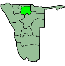
Oshikoto is one of the fourteen regions of Namibia, named after Lake Otjikoto near its former capital Tsumeb. The capital of Oshikoto is Omuthiya. The northern part of the region is agricultural, whereas the main economic activities in the southern part are cattle rearing and mining. The two areas have important cultural and historical links in that the Ndonga people have extracted copper at Tsumeb since the earliest times in order to make rings and tools.

Osiek is a village in the administrative district of Gmina Lubin, within Lubin County, Lower Silesian Voivodeship, in south-western Poland. Prior to 1945 it was in Germany. It was the birthplace of the Protestant Reformer Kaspar Schwenkfeld von Ossig in 1490. It lies approximately 5 kilometres (3 mi) south-east of Lubin and 63 km (39 mi) north-west of the regional capital Wrocław.
Gołoty is a village in the administrative district of Gmina Unisław, within Chełmno County, Kuyavian-Pomeranian Voivodeship, in north-central Poland. It lies approximately 4 kilometres (2 mi) north-east of Unisław, 15 km (9 mi) south of Chełmno, 26 km (16 mi) north-west of Toruń, and 31 km (19 mi) north-east of Bydgoszcz.

Valea Seacă is a commune in Bacău County, Romania. It is composed of two villages, Cucova and Valea Seacă.
Miedzna Murowana is a village in the administrative district of Gmina Żarnów, within Opoczno County, Łódź Voivodeship, in central Poland. It lies approximately 8 kilometres (5 mi) north-east of Żarnów, 10 km (6 mi) south of Opoczno, and 76 km (47 mi) south-east of the regional capital Łódź.
Kamień is a village in the administrative district of Gmina Ceków-Kolonia, within Kalisz County, Greater Poland Voivodeship, in west-central Poland. It lies approximately 8 kilometres (5 mi) south-west of Ceków-Kolonia, 14 km (9 mi) north-east of Kalisz, and 110 km (68 mi) south-east of the regional capital Poznań.
Borów is a village in the administrative district of Gmina Opatówek, within Kalisz County, Greater Poland Voivodeship, in west-central Poland. It lies approximately 2 kilometres (1 mi) north of Opatówek, 11 km (7 mi) east of Kalisz, and 116 km (72 mi) south-east of the regional capital Poznań.
Sokółki is a village in the administrative district of Gmina Kazimierz Biskupi, within Konin County, Greater Poland Voivodeship, in west-central Poland. It lies approximately 7 kilometres (4 mi) south-east of Kazimierz Biskupi, 6 km (4 mi) north of Konin, and 91 km (57 mi) east of the regional capital Poznań.
Wysokie is a village in the administrative district of Gmina Kramsk, within Konin County, Greater Poland Voivodeship, in west-central Poland. It lies approximately 4 kilometres (2 mi) south-east of Kramsk, 14 km (9 mi) east of Konin, and 108 km (67 mi) east of the regional capital Poznań.
Biela is a village in the administrative district of Gmina Wilczyn, within Konin County, Greater Poland Voivodeship, in west-central Poland. It lies approximately 7 kilometres (4 mi) south-east of Wilczyn, 26 km (16 mi) north of Konin, and 90 km (56 mi) east of the regional capital Poznań.
Posadowo is a village in the administrative district of Gmina Lwówek, within Nowy Tomyśl County, Greater Poland Voivodeship, in west-central Poland. It lies approximately 4 kilometres (2 mi) north-east of Lwówek, 18 km (11 mi) north of Nowy Tomyśl, and 47 km (29 mi) west of the regional capital Poznań.
Markowice is a village in the administrative district of Gmina Kleszczewo, within Poznań County, Greater Poland Voivodeship, in west-central Poland. It lies approximately 6 kilometres (4 mi) south-east of Kleszczewo and 25 km (16 mi) south-east of the regional capital Poznań.

Krosno is a village in the administrative district of Gmina Mosina, within Poznań County, Greater Poland Voivodeship, in west-central Poland. It lies approximately 2 kilometres (1 mi) south-west of Mosina and 20 km (12 mi) south of the regional capital Poznań.
Zmysłowo is a village in the administrative district of Gmina Środa Wielkopolska, within Środa Wielkopolska County, Greater Poland Voivodeship, in west-central Poland. It lies approximately 7 kilometres (4 mi) north-west of Środa Wielkopolska and 26 km (16 mi) south-east of the regional capital Poznań.

Aminuis Constituency is a electoral constituency in the Omaheke Region of Namibia. It has 12,343 inhabitants, its district capital is the settlement of Aminuis. The constituency forms part of the border between Namibia and Botswana.
Okorukambe Constituency, until 2013 Steinhausen Constituency, is an electoral constituency in the Omaheke Region of Namibia. It has 9,066 inhabitants. Its district capital is the settlement of Steinhausen. It further contains the settlements of Witvlei and Omitara.
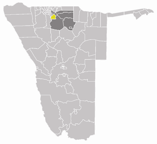
Omuthiyagwiipundi Constituency is an electoral constituency in the Oshikoto Region of Namibia. It has 21,884 inhabitants and contains the settlements of Omuthiya and Iipundi. The only problem is that there is not much of industrial activities which can appeal investors. It is fast-growing and developing, but after ten years, there is not much to attract businesses.

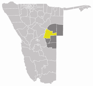
Onyaanya Constituency is an electoral constituency in the Oshikoto Region of Namibia. It has 13,474 inhabitants; its district capital is the settlement of Onyaanya.
Reverend Juuso Shikongo Senior Secondary School is a Namibian public school in the Omuntele Constituency in the Oshikoto Region about 60 kilometres southeast of Ondangwa, which was in 2013 inaugurated by then Education Minister Dr David Namwandi. The school is named after the founder of the Evangelical Lutheran Church in Namibia 's Omuntele congregation, Reverend Juuso Shikongo, the school started operating from a sister school, Uukule Senior Secondary School situated at Onyaanya Constituency some 30 kilometres away, in 2011 before moving to Omuntele at the beginning of the year 2013. In his official inauguration address, the education minister David Namwandi pointed out that Government has spent N$120 million on the construction of classrooms, offices and hostels for the school.