Omuthiyagwiipundi Constituency

Last updated

Omuthiyagwiipundi Constituency is an electoral constituency in the Oshikoto Region of Namibia. It has 21,884 inhabitants [1] and contains the settlements of Omuthiya and Iipundi. The only problem is that there is not much of industrial activities which can appeal investors. It is fast-growing and developing, but after ten years, there is not much to attract businesses.

Constituencies of Namibia Wikimedia list article

Each of the 14 regions in Namibia is further subdivided into electoral constituencies. The size of the constituencies varies with the size and population of each region. There are currently 121 constituencies in Namibia. The most populous constituency is Walvis Bay Urban; the least populous is Walvis Bay Rural, both in the Erongo region.

Oshikoto Region Region in Namibia

Oshikoto is one of the fourteen regions of Namibia, named after Lake Otjikoto near its former capital Tsumeb. The capital of Oshikoto is Omuthiya. The northern part of the region is agricultural, whereas the main economic activities in the southern part are cattle rearing and mining. The two areas have important cultural and historical links in that the Ndonga people have extracted copper at Tsumeb since the earliest times in order to make rings and tools.

Namibia republic in southern Africa

Namibia, officially the Republic of Namibia, is a country in southern Africa. Its western border is the Atlantic Ocean; it shares land borders with Zambia and Angola to the north, Botswana to the east and South Africa to the south and east. Although it does not border Zimbabwe, less than 200 metres of the Zambezi River separates the two countries. Namibia gained independence from South Africa on 21 March 1990, following the Namibian War of Independence. Its capital and largest city is Windhoek, and it is a member state of the United Nations (UN), the Southern African Development Community (SADC), the African Union (AU), and the Commonwealth of Nations.

Contents

Politics

As in all constituencies in Oshikoto, SWAPO won the 2015 regional election by a landslide. Samuel Panduleni Shivute gained 5,092 votes, while the only opposition candidate Epafras Nghinamundova of the Rally for Democracy and Progress (RDP) gained 239. [2]

SWAPO political party

The South-West Africa People’s Organisation (SWAPO),, and officially known as SWAPO Party of Namibia, is a political party and former independence movement in Namibia. It has been the governing party in Namibia since the country achieved independence in 1990. The party continues to be dominated in number and influence by the Ovambo ethnic group.

Rally for Democracy and Progress (Namibia) political party in Namibia

The Rally for Democracy and Progress (RDP) is an opposition political party in Namibia. It was launched on 17 November 2007 under the leadership of Hidipo Hamutenya and Jesaya Nyamu, both former leading members of the ruling SWAPO party and cabinet ministers. Hamutenya had unsuccessfully sought the SWAPO nomination for President in 2004. At the time of the RDP's launch, it was considered to represent the strongest challenge to SWAPO's political dominance since the country gained its independence in 1990. According to Hamutenya, speaking at the RDP's launch, the party was "born in response to our people's deep longing for a vision, political direction and the rekindling of their hopes and aspiration for a better and prosperous future".

See also

Related Research Articles

Otjozondjupa Region Region in Namibia

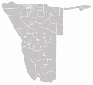
Otjozondjupa region is one of the fourteen regions of Namibia, whose capital is Otjiwarongo. An outstanding landmark within this region is the Waterberg Plateau Park. Administration offices are based in Otjiwarongo which is the largest town in the region.

Omaheke Region Region in Namibia

Omaheke is one of the fourteen regions of Namibia, its capital is Gobabis. It lies on the eastern border of Namibia and is the Western extension of the Kalahari desert. The name Omaheke is the Herero word for Sandveld.

Epupa Constituency constituency of Namibia

Epupa is a constituency in the Kunene Region of Namibia. Its population is 12,816. Epupa is also the location of the Epupa Falls, located on the Angolan-Namibian border.

Mariental Rural is a constituency in the Hardap region of Namibia. It has a population of 13,596, its administrative centre is the city of Mariental.

Omuthiya Place in Oshikoto Region, Namibia

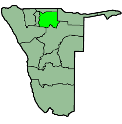
Omuthiyagwiipundi is the capital of Oshikoto Region in northern Namibia, situated approximately 10 kilometres (6.2 mi) from Etosha National Park. It has about 5,000 residents. Prior to Omuthiya, Tsumeb was the regional capital.

Oniipa Town in Oshikoto Region, Namibia

Oniipa is a town in the Oshikoto Region of northern Namibia and the district capital of the Oniipa electoral constituency. It lies just outside Ondangwa. It is the hometown of former Lutheran bishop and liberation leader Leonard Auala.

Etayi Constituency

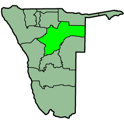
Etayi Constituency is an electoral constituency in the Omusati Region of Namibia. It has 34,970 inhabitants, its district capital is the settlement of Etayi. The constituency contains the settlements of Iipandayamiti, Oneheke, Onheleiwa, Otindi, Ekangolinene, Oshivanda, Onamhindi, Omutundungu, Olupandu, Onampira, Oshipya, and Oikokola.

Ogongo Constituency is a electoral constituency in the Omusati Region northern part of Namibia. It has 18,498 inhabitants, its district capital is the settlement of Ogongo. The constituency further contains the settlements of Eengolo, Eendombe, Pyamukuyu, Iipanda, Ombathi, and Omuthitu.

Okalongo Constituency

Okalongo Constituency is an electoral constituency in the Omusati Region of Namibia on the border to Angola. It has 28,657 inhabitants. The constituency's capital is the settlement of Okalongo. It further contains villages such as: Onandjaba, Omatwadiva, Onaidjimba, Okafitu Kauvale, Olwiili, Ongolo, Ondudu, Onembaba, Ondobe Yehumba, Ondobe Yefidi, Ohakapeke, Olupandu, Epoko, Olupito, Onambome and many more.

Eengodi Constituency is an electoral constituency in the Oshikoto Region of Namibia. It has 14,995 inhabitants.

Guinas Constituency constituency of Namibia

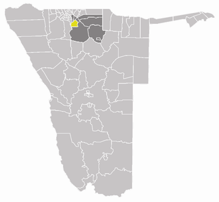
Guinas Constituency is an electoral constituency in the Oshikoto Region of Namibia. It has 8,435 inhabitants and consists of the rural area surrounding the mining town of Tsumeb. Larger settlements in the Guinas constituency are Oshivelo and Tsintsabis.

Okankolo Constituency is an electoral constituency in the Oshikoto Region of Namibia. It has 12,926 inhabitants, the district capital is the settlement of Okankolo. Settlements in this constituency include Onkumbula, Omakango, Omunduta, Omhuuda, and Omutwewomedi.

Olukonda Constituency is an electoral constituency in the Oshikoto Region of Namibia. It has 9,094 inhabitants, the district capital is the settlement of Olukonda.

Omuntele Constituency

Omuntele Constituency is an electoral constituency in the Oshikoto Region on the northern part of Namibia. It has 21,884 inhabitants. The district capital is the settlement of Omuntele.

Oniipa Constituency is an electoral constituency in the Oshikoto Region of Namibia. It has 23,913 inhabitants, its district capital is the settlement of Oniipa. Further settlements in this constituency are Oshigambo, and Onanjokwe.

Onyaanya Constituency

Onyaanya Constituency is an electoral constituency in the Oshikoto Region of Namibia. It has 13,474 inhabitants; its district capital is the settlement of Onyaanya.

Omatako Constituency

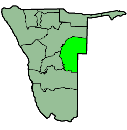
Omatako Constituency is an electoral constituency in the Otjozondjupa Region of Namibia. It has 11,998 inhabitants and contains the settlements of Kalkfeld, Hochfeld and Ovitoto, as well as the Osire refugee camp and the Osona military base.

Kavango West Region in Namibia

Kavango West is one of the fourteen regions of Namibia. Its capital is Nkurenkuru. The Region was created in 2013 when the Kavango Region was split into Kavango East and Kavango West.

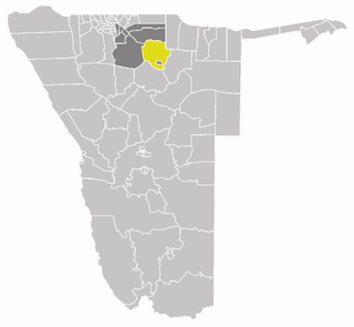
Tsumeb Constituency is an electoral constituency in the Oshikoto Region of Namibia, comprising the town area and surroundings of Tsumeb. It has a population of 44,113.

References

Coordinates: 17°43′00″S16°13′00″E / 17.7167°S 16.2167°E / -17.7167; 16.2167

Geographic coordinate system Coordinate system

A geographic coordinate system is a coordinate system that enables every location on Earth to be specified by a set of numbers, letters or symbols. The coordinates are often chosen such that one of the numbers represents a vertical position and two or three of the numbers represent a horizontal position; alternatively, a geographic position may be expressed in a combined three-dimensional Cartesian vector. A common choice of coordinates is latitude, longitude and elevation. To specify a location on a plane requires a map projection.