Omuntele Constituency

Last updated
Omuntele Constituency (yellow) in the Oshikoto Region (dark grey) Wahlkreis Omuntele in Oshikoto.png
Omuntele Constituency (yellow) in the Oshikoto Region (dark grey)

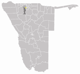
Omuntele Constituency is an electoral constituency in the Oshikoto Region on the northern part of Namibia. It has 21,884 inhabitants. The district capital is the settlement of Omuntele. [1]

Constituencies of Namibia Wikimedia list article

Each of the 14 regions in Namibia is further subdivided into electoral constituencies. The size of the constituencies varies with the size and population of each region. There are currently 121 constituencies in Namibia. The most populous constituency is Walvis Bay Urban; the least populous is Walvis Bay Rural, both in the Erongo region.

Oshikoto Region Region in Namibia

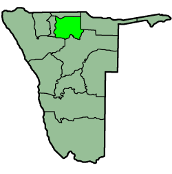
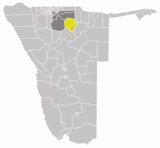
Oshikoto is one of the fourteen regions of Namibia, named after Lake Otjikoto near its former capital Tsumeb. The capital of Oshikoto is Omuthiya. The northern part of the region is agricultural, whereas the main economic activities in the southern part are cattle rearing and mining. The two areas have important cultural and historical links in that the Ndonga people have extracted copper at Tsumeb since the earliest times in order to make rings and tools.

Namibia republic in southern Africa

Namibia, officially the Republic of Namibia, is a country in southern Africa. Its western border is the Atlantic Ocean; it shares land borders with Zambia and Angola to the north, Botswana to the east and South Africa to the south and east. Although it does not border Zimbabwe, less than 200 metres of the Zambezi River separates the two countries. Namibia gained independence from South Africa on 21 March 1990, following the Namibian War of Independence. Its capital and largest city is Windhoek, and it is a member state of the United Nations (UN), the Southern African Development Community (SADC), the African Union (AU), and the Commonwealth of Nations.

Contents

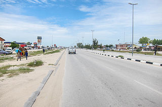
The constituency is situated in the northwest part of Oshikoto about 60 km southeast of Ondangwa. The constituency is currently led by Sacky Nangula, councillor for SWAPO. It is dominated by Oshiwambo speaking people and a small number San people. People in the area survive in cultivating crops. Mahangu is the principal crop in the area.[ citation needed ]

Ondangwa Town in Oshana Region, Namibia

Ondangwa is a town of 23,000 inhabitants in the Oshana Region of northern Namibia, bordering Oshikoto Region. Ondangwa was first established as a mission station of the Finnish Missionary Society in 1890. In 1914 it became a local seat of government.

SWAPO political party

The South-West Africa People’s Organisation (SWAPO),, and officially known as SWAPO Party of Namibia, is a political party and former independence movement in Namibia. It has been the governing party in Namibia since the country achieved independence in 1990. The party continues to be dominated in number and influence by the Ovambo ethnic group.

San people members of various indigenous hunter-gatherer people of Southern Africa

The San or Saan peoples, also known as the Bushmen, are members of various Khoesān-speaking indigenous hunter-gatherer groups that are the first nations of Southern Africa, and whose territories span Botswana, Namibia, Angola, Zambia, Zimbabwe, Lesotho and South Africa. There is a significant linguistic difference between the northern peoples living between the Okavango River in Botswana and Etosha National Park in northwestern Namibia, extending up into southern Angola; the central peoples of most of Namibia and Botswana, extending into Zambia and Zimbabwe; and the southern people in the central Kalahari towards the Molopo River, who are the last remnant of the previously extensive indigenous Sān of South Africa.

History

The area was established[ clarification needed ] by Silvanus Nyambali Nehale, son of Ondonga Chief Nehale Mpingana. During the Namibian War of Independence many people from this area went into exile to Angola and took up arms there. However, between 1976 and 1980 combatants of the People's Liberation Army of Namibia (PLAN) lived at Omuntele as civilians as part of a covert reconnaissance operation. There were a number of battles in and around Omuntele like the one at Oshalongo in which Commander Max Nekongo was seriously injured. Nekongo is currently the councillor of Onayena Constituency. [2]

Ondonga is a traditional kingdom of the Ovambo people in what is today northern Namibia. Its capital is Ondangwa, and the kingdom's palace is at Onamungundo. Its people call themselves Aandonga. They speak the Ndonga dialect.

A tribal chief is the leader of a tribal society or chiefdom.

Politics

Omuntele constituency is traditionally a stronghold of the South West Africa People's Organization (SWAPO) party.

In the 2009 general election, incumbent President and SWAPO candidate Hifikepunye Pohamba received 98% of the votes for President. [3] In the 2015 local and regional elections the SWAPO candidate won uncontested and became councillor after no opposition party nominated a candidate. [4]

Hifikepunye Pohamba 2nd president of Namibia

Hifikepunye Lucas Pohamba is a Namibian politician who served as the second President of Namibia from 21 March 2005 to 21 March 2015. He won the 2004 election overwhelmingly as the candidate of SWAPO, the ruling party, and was reelected in 2009. Pohamba was the president of SWAPO from 2007 until his retirement in 2015. He is a recipient of the Ibrahim Prize.

See also

Related Research Articles

Omuthiya Place in Oshikoto Region, Namibia

Omuthiyagwiipundi is the capital of Oshikoto Region in northern Namibia, situated approximately 10 kilometres (6.2 mi) from Etosha National Park. It has about 5,000 residents. Prior to Omuthiya, Tsumeb was the regional capital.

Oniipa Town in Oshikoto Region, Namibia

Oniipa is a town in the Oshikoto Region of northern Namibia and the district capital of the Oniipa electoral constituency. It lies just outside Ondangwa. It is the hometown of former Lutheran bishop and liberation leader Leonard Auala.

Outapi Constituency

Outapi Constituency is an electoral constituency in the Omusati Region of Namibia on the border to Angola. It has 30,313 inhabitants, its district capital is the town of Outapi.

Okatana Constituency

Okatana Constituency is an electoral constituency in the Oshana Region of Namibia. It has 15,562 inhabitants, its district capital is the settlement of Okatana.

Okatyali Constituency

Okatyali Constituency is an electoral constituency in the Oshana Region of Namibia. It has 2,815 inhabitants, its district capital is the settlement of Okatyali.

Ompundja Constituency

Ompundja Constituency is an electoral constituency in the Oshana Region of Namibia. It has 4,423 inhabitants. It is the birthplace of ambassador, politician and businessperson Monica Nashandi.

Uukwiyu Constituency

Uukwiyu Constituency is an electoral constituency in the Oshana Region of Namibia. It has 11,894 inhabitants, its district capital is the settlement of Uukwiyu.

Uuvudhiya Constituency

Uuvudhiya Constituency is an electoral constituency in the Oshana Region of Namibia. It has 4,357 inhabitants, its district capital is the settlement of Uuvudhiya. The constituency had 2,869 registered voters as of 2004.

Eengodi Constituency is an electoral constituency in the Oshikoto Region of Namibia. It has 14,995 inhabitants.

Guinas Constituency constituency of Namibia

Guinas Constituency is an electoral constituency in the Oshikoto Region of Namibia. It has 8,435 inhabitants and consists of the rural area surrounding the mining town of Tsumeb. Larger settlements in the Guinas constituency are Oshivelo and Tsintsabis.

Okankolo Constituency is an electoral constituency in the Oshikoto Region of Namibia. It has 12,926 inhabitants, the district capital is the settlement of Okankolo. Settlements in this constituency include Onkumbula, Omakango, Omunduta, Omhuuda, and Omutwewomedi.

Olukonda Constituency is an electoral constituency in the Oshikoto Region of Namibia. It has 9,094 inhabitants, the district capital is the settlement of Olukonda.

Onayena Constituency human settlement

Onayena Constituency is an electoral constituency in the Oshikoto Region of Namibia. It has 15,684 inhabitants; its district capital is the settlement of Onayena. Currently the Councillor of Onayena is Natangwe Indongo, a former school teacher at Nehale Senior Secondary School. The Constituency's population has grown significantly over recent years, dominated by the Ovambo language speaking people and a small group of San people.

Oniipa Constituency is an electoral constituency in the Oshikoto Region of Namibia. It has 23,913 inhabitants, its district capital is the settlement of Oniipa. Further settlements in this constituency are Oshigambo, and Onanjokwe.

Onyaanya Constituency

Onyaanya Constituency is an electoral constituency in the Oshikoto Region of Namibia. It has 13,474 inhabitants; its district capital is the settlement of Onyaanya.

Nehale Senior Secondary School is a public school in Onayena, Oshikoto Region, Namibia. Established in 1976, it is the second oldest school in the region but also in the entire former Ovamboland. Nehale SSS is named after Nehale Mpingana, king of the Ondonga. The school is located at Onayena, approximately 20 kilometres east of Ondangwa.

Nehale lyaMpingana Constituency is an electoral constituency in the Oshikoto Region of Namibia, named after Nehale lya Mpingana, one of Namibia's National Heroes. It was created in August 2013, following a recommendation of the Fourth Delimitation Commission of Namibia, and in preparation of the 2014 general election. The administrative centre of Nehale lyaMpingana is the settlement of Okoloti.

Ondangwa Rural

Ondangwa Rural is an electoral constituency in the Oshana Region of Namibia. It has 13,613 inhabitants. Ondangwa Rural was created by splitting the former constituency of Ondangwa into a rural and an urban part in August 2013, following a recommendation of the Fourth Delimitation Commission of Namibia, and in preparation of the 2014 general election. The administrative centre of the constituency is the settlement Eheke.

Omuntele is a village with almost 2,000 inhabitants in the Oshikoto region in the north-east of Namibia. The village is located in a high plateau with 1,089 meters above sea level. D. Sea level and has an airfield.

References

  1. Constituencies of Namibia, 2004
  2. Nambala, SVV (July 2010). "Omuntele Combatants". Prime Focus Magazine.
  3. Omuntele Swapoparty.org results
  4. Kangootui, Nomhle (23 October 2015). "Swapo gets ǃNamiǂNûs uncontested". The Namibian . Archived from the original on October 24, 2015.

Coordinates: 18°14′00″S16°14′00″E / 18.2333°S 16.2333°E / -18.2333; 16.2333

Geographic coordinate system Coordinate system

A geographic coordinate system is a coordinate system that enables every location on Earth to be specified by a set of numbers, letters or symbols. The coordinates are often chosen such that one of the numbers represents a vertical position and two or three of the numbers represent a horizontal position; alternatively, a geographic position may be expressed in a combined three-dimensional Cartesian vector. A common choice of coordinates is latitude, longitude and elevation. To specify a location on a plane requires a map projection.