Limestone is a type of carbonate sedimentary rock which is the main source of the material lime. It is composed mostly of the minerals calcite and aragonite, which are different crystal forms of CaCO3. Limestone forms when these minerals precipitate out of water containing dissolved calcium. This can take place through both biological and nonbiological processes, though biological processes, such as the accumulation of corals and shells in the sea, have likely been more important for the last 540 million years. Limestone often contains fossils which provide scientists with information on ancient environments and on the evolution of life.

Sandstone is a clastic sedimentary rock composed mainly of sand-sized silicate grains, cemented together by another mineral. Sandstones comprise about 20–25% of all sedimentary rocks.

Sedimentary rocks are types of rock that are formed by the accumulation or deposition of sediments, ie. mineral or organic particles, at Earth's surface, followed by cementation. Sedimentation is the collective name for processes that cause these particles to settle in place. The particles that form a sedimentary rock are called sediment, and may be composed of geological detritus (minerals) or biological detritus. The geological detritus originated from weathering and erosion of existing rocks, or from the solidification of molten lava blobs erupted by volcanoes. The geological detritus is transported to the place of deposition by water, wind, ice or mass movement, which are called agents of denudation. Biological detritus was formed by bodies and parts of dead aquatic organisms, as well as their fecal mass, suspended in water and slowly piling up on the floor of water bodies. Sedimentation may also occur as dissolved minerals precipitate from water solution.

Sediment is a solid material that is transported to a new location where it is deposited. It occurs naturally and, through the processes of weathering and erosion, is broken down and subsequently transported by the action of wind, water, or ice or by the force of gravity acting on the particles. For example, sand and silt can be carried in suspension in river water and on reaching the sea bed deposited by sedimentation; if buried, they may eventually become sandstone and siltstone through lithification.

Stromatolites or stromatoliths are layered sedimentary formations (microbialite) that are created mainly by photosynthetic microorganisms such as cyanobacteria, sulfate-reducing bacteria, and Pseudomonadota. These microorganisms produce adhesive compounds that cement sand and other rocky materials to form mineral "microbial mats". In turn, these mats build up layer by layer, growing gradually over time.

Cyanobacteria, also called Cyanobacteriota or Cyanophyta, are a phylum of autotrophic gram-negative bacteria that can obtain biological energy via oxygenic photosynthesis. The name "cyanobacteria" refers to their bluish green (cyan) color, which forms the basis of cyanobacteria's informal common name, blue-green algae, although as prokaryotes they are not scientifically classified as algae.

Tufa is a variety of limestone formed when carbonate minerals precipitate out of water in unheated rivers or lakes. Geothermally heated hot springs sometimes produce similar carbonate deposits, which are known as travertine or thermogene travertine. Tufa is sometimes referred to as meteogene travertine.

Peinado is a stratovolcano in Catamarca Province, Argentina. It consists of a volcanic cone with a summit crater, surrounded at its foot by lava flows erupted from flank vents. It began erupting about 100,000 years ago, with the last eruption about 36,800 years ago. Future eruptions are possible.

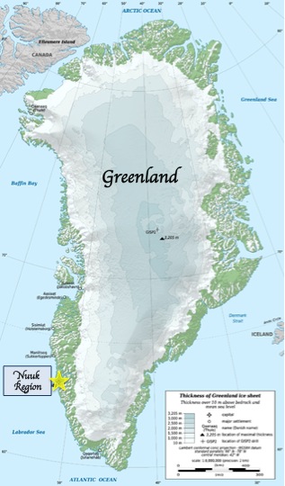
The Isua Greenstone Belt is an Archean greenstone belt in southwestern Greenland, aged between 3.7 and 3.8 billion years. The belt contains variably metamorphosed mafic volcanic and sedimentary rocks, and is the largest exposure of Eoarchaean supracrustal rocks on Earth. Due to its age and low metamorphic grade relative to many Eoarchaean rocks, the Isua Greenstone Belt has become a focus for investigations on the emergence of life and the style of tectonics that operated on the early Earth.

Thrombolites are clotted accretionary structures formed in shallow water by the trapping, binding, and cementation of sedimentary grains by biofilms of microorganisms, especially cyanobacteria.
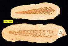
Girvanella is a fossil thought to represent the calcified sheath of a filamentous cyanobacterium known from the Burgess Shale and other Cambrian fossil deposits. Specimens are also known from the Early Ordovician San Juan Formation, Argentina.

Microbially induced sedimentary structures (MISS) are primary sedimentary structures formed by the interaction of microbes with sediment and physical agents of erosion, deposition, and transportation. The structures commonly form when microbial mats are preserved in the sedimentary geological record. There are 17 main types of macroscopic and microscopic MISS. Of those, wrinkle structures and microbial mat chips are the most abundant in the fossil record. Other MISS include sinoidal structures, polygonal oscillation cracks, multidirected ripple marks, erosional remnants and pockets, or gas domes.
The extinct genus Hedstroemia was once thought to be a rivulariacean cyanobacterium. It forms oval blobs composed of sinuous tubes that have rounded outlines and occurs in conjunction with Solenopora.

The Barberton Greenstone Belt of eastern South Africa contains some of the most widely accepted fossil evidence for Archean life. These cell-sized prokaryote fossils are seen in the Barberton fossil record in rocks as old as 3.5 billion years. The Barberton Greenstone Belt is an excellent place to study the Archean Earth due to exposed sedimentary and metasedimentary rocks.

Corrida de Cori is a mountain range in Argentina and Chile. It consists of several aligned volcanoes, including Cerro Escorial, which exceed 5 kilometres (3.1 mi) in elevation. The range, together with several local volcanoes, forms an alignment that may be controlled by a fault system. The volcanoes erupted mainly andesite and basaltic andesite, they were active in the Plio-Pleistocene with the most recent activity occurring at Cerro Escorial and at a cinder cone east of the range. There are two mines in the area, with a weather station nearby.

Antofalla is a Miocene-Pliocene volcano in Argentina's Catamarca Province. It is part of the volcanic segment of the Andes in Argentina, and it is considered to be part of the Central Volcanic Zone, one of the volcanic zones of the Andes. Antofalla forms a group of volcanoes that are aligned on and behind the main volcanic arc. Antofalla itself is a remote volcano.
Automicrite is autochthonous micrite, that is, a carbonate mud precipitated in situ and made up of fine-grained calcite or aragonite micron-sized crystals. It precipitates on the sea floor or within the sediment as an authigenic mud thanks to physicochemical, microbial, photosynthetic and biochemical processes. It has peculiar fabrics and uniform mineralogical and chemical composition.
"Porostromata" is an antiquated form taxon that refers to fossil cyanobacteria. The term porostromate is also used as a descriptor of textures and microstructure of stromatolites and oncolites which contain tubules or other cellular structures.
"Spongiostromata" is an antiquated form taxon that refers primarily to fossil cyanobacteria. "Spongiostromate" is also used to describe stromatolites and oncolites that do not preserve clear tubules or other cellular microstructure.

Laguna Negra is a lake in the Catamarca Province of Argentina. It lies on the Puna high plateau next to two other lakes and salt flats. The lake is less than 2 metres deep and forms a rough rectangle with a surface of 8.6 square kilometres (3.3 sq mi). Laguna Negra loses its water through evaporation, and is replenished through surface runoff and groundwater which ultimately originate to a large part from snowmelt. The waters of the lake are salty.


