Oost-Indisch Huis

Last updated
Oost-Indisch Huis
Oih1.jpg
Inner courtyard of the Oost-Indisch Huis. Source: bma.amsterdam.nl
Typebuilding
LocationKloveniersburgwal 48
1012 CX Amsterdam
Built1606, 1633
Built for Dutch East India Company
Original useheadquarters,
Dutch East India Company
Architect Hendrick de Keyser
Owner University of Amsterdam
Website http://www.uva.nl/locaties/binnenstad/bushuis.html
TypeHistorical
Reference no.2012
17th-century etching of the Oost-Indisch Huis. Source: bma.amsterdam.nl Gravure van het Oost Indisch Huis (17e eeuw).jpg
17th-century etching of the Oost-Indisch Huis. Source: bma.amsterdam.nl
Oost-Indisch Huis by Reinier Vinkeles, 1768. Source: bma.amsterdam.nl Oih amsterdam.jpg
Oost-Indisch Huis by Reinier Vinkeles, 1768. Source: bma.amsterdam.nl
The restored meeting room of the Heeren XVII (the Lords Seventeen), the regents of the Dutch East India Company DirectiekamerVOC.jpg
The restored meeting room of the Heeren XVII (the Lords Seventeen), the regents of the Dutch East India Company
Eastern wing along Kloveniersburgwal canal added in 1891 to replace the Bushuis Bushuis-Adam-Kloveniersburggracht.jpg
Eastern wing along Kloveniersburgwal canal added in 1891 to replace the Bushuis

The Oost-Indisch Huis (Dutch for "East India House") is an early 17th-century building in the centre of Amsterdam. It was the headquarters of the Amsterdam chamber of the Dutch East India Company (Vereenigde Oostindische Compagnie or VOC). It is a listed Dutch national heritage site ( rijksmonument ). [1]

Contents

History

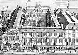
In 1603, the Amsterdam chamber of the East India Company began using part of the Bushuis armory on the Kloveniersburgwal canal as a warehouse. Two years later, [2] the East India Company took over the whole building. However, the company still lacked meeting and office space, so a new building was constructed directly adjacent to the Bushuis. This building, completed in 1606, was called the Oost-Indisch Huis ("East India House") and was the first building especially built for the East India Company. In 1663-64, the western wing was extended. In addition, a northern wing was added, so that the building now also bordered the street Oude Hoogstraat. The last major extension was added between 1658 and 1661. A gate with Tuscan-style pilasters and a small tunnel lead to an inner courtyard with elegant facades in Amsterdam Renaissance style, a style closely identified with the architect Hendrick de Keyser, who was most likely responsible for designing the building. [3]

The Oost-Indisch Huis was the first building especially built for the East India Company. [3] It was multifunctional, serving simultaneously as a warehouse, administrative center, office and auction room. The building served as the headquarters [2] of the Amsterdam chamber (Kamer) of the East India Company. The 20 regents of the Amsterdam chamber met here. In addition, the majority of meetings of the Heeren XVII (the Lords Seventeen), the regents of the East India Company, were also held at the Oost-Indisch Huis. Shipcrews were recruited here, and the archives and map collection of the East India Company were also kept here. [3]

After the East India Company was dissolved in 1798, the building served until 1808 as the seat of the colonial government of the Batavian Republic. In 1891, the adjacent Bushuis was demolished and a new eastern wing, designed by Cornelis Peters, was added along the inner courtyard.

In 1976 the building underwent restoration. During this restoration, the grand meeting room was also reconstructed. The building has been declared a national monument (rijksmonument). [1] The building is now in use by the University of Amsterdam. [2]

The East India Company chambres in Rotterdam, Delft, Enkhuizen and Hoorn also had an Oost-Indisch Huis as their headquarters. The building in Rotterdam was destroyed during the Rotterdam Blitz in 1940; however, the ones in Delft and Hoorn are still in existence.

Amsterdam also has a West-Indisch Huis, which served as headquarters of the Dutch West India Company, and which has also been declared a Dutch national monument. [4]

Related Research Articles

Best, Netherlands Municipality in North Brabant, Netherlands

Best is a municipality and a village in the southern Netherlands. It is situated northwest of the city Eindhoven, and is also part of the agglomeration of this city.

Jan Pieterszoon Coen Dutch colonial administrator

Jan Pieterszoon Coen was an officer of the Dutch East India Company (VOC) in the early 17th century, holding two terms as Governor-General of the Dutch East Indies. He was the founder of Batavia, capital of the Dutch East Indies. Renowned for providing the impulse that set the VOC on the path to dominance in the Dutch East Indies, he was long considered a national hero in the Netherlands. Since the 19th century, his legacy has become controversial due to the violence he employed, especially during the last stage of the Dutch conquest of the Banda Islands, in order to secure a trade monopoly on nutmeg, mace and clove.

University of Amsterdam Public research university in Amsterdam, Netherlands

The University of Amsterdam is a public research university located in Amsterdam, Netherlands. The UvA is one of two large, publicly funded research universities in the city, the other being the Vrije Universiteit Amsterdam (VU). Established in 1632 by municipal authorities and later renamed for the city of Amsterdam, the University of Amsterdam is the third-oldest university in the Netherlands. It is one of the largest research universities in Europe with 31,186 students, 4,794 staff, 1,340 PhD students and an annual budget of €600 million. It is the largest university in the Netherlands by enrollment. The main campus is located in central Amsterdam, with a few faculties located in adjacent boroughs. The university is organised into seven faculties: Humanities, Social and Behavioural Sciences, Economics and Business, Science, Law, Medicine, Dentistry.

Randstad Conurbation in Netherlands

The Randstad is a conurbation in the central-western Netherlands consisting primarily of the four largest Dutch cities and their surrounding areas. Among other things, it contains the Port of Rotterdam, the Port of Amsterdam, and Amsterdam Airport Schiphol. With a population of approximately 8.4 million people it is one of the largest metropolitan regions in Europe, comparable in population size to the Milan metropolitan area or the San Francisco Bay Area, and covers an area of approximately 8,287 km2 (3,200 sq mi). With a population density of 1,500/km2 (3,900/sq mi) it also is one of the most important and densely populated economic areas in northwestern Europe. It encompasses both the Amsterdam metropolitan area and Rotterdam–The Hague metropolitan area. It is part of the larger Blue Banana megalopolis.

Hendrick de Keyser

Hendrick de Keyser was a Dutch sculptor, merchant in Belgium bluestone, and architect who was instrumental in establishing a late Renaissance form of Mannerism changing into Baroque. Most of his works appeared in Amsterdam, some elsewhere in the Dutch Republic. He was the father of Pieter and Thomas de Keyser and Willem, and the uncle of Huybert de Keyser, who became his apprentices and all involved in building, decoration and architecture.

Rijksmonument

A rijksmonument is a national heritage site of the Netherlands, listed by the agency Rijksdienst voor het Cultureel Erfgoed (RCE) acting for the Dutch Ministry of Education, Culture and Science.

West-Indisch Huis (Amsterdam)

The West-Indisch Huis is the former headquarters of the Dutch West India Company in Amsterdam. In this building, the Dutch West India Company's governors in 1625 ordered the construction of a fort on the island of Manhattan, laying the foundations for New York City.

Pieter de Keyser

Pieter de Keyser was a Dutch Golden Age architect (bouwmeester) and sculptor. He followed in the footsteps of his father Hendrick de Keyser and completed a number of Hendrick de Keyser's buildings after his death in 1621.

Korenbeurs (Amsterdam)

The Korenbeurs was a 17th-century commodity market in Amsterdam where grain was traded. The building stood on the banks of the Amstel, on the western side (Nieuwezijde) of the Damrak. It was directly south of the Oude Brug bridge, on a spot now occupied by the former stock and commodity exchange Beurs van Berlage.

History of Wageningen History of town in Gelderland, Netherlands

The area around the town of Wageningen was settled as early as the 9th century. Located on the north bank of the Nederrijn river, between the Gelderse valley and the Veluwe, a wooded, hilly, glacial moraine, by the 12th century it was part of the Duchy of Guelders, in the Holy Roman Empire. Wageningen received its city charter from Count Otto II on June 12, 1263. Today, it is in the province of Gelderland, in east-central Netherlands.

Smallest house in Amsterdam

The smallest house in Amsterdam is located at Oude Hoogstraat 22 in the old city center of Amsterdam, next to the Oost-Indisch Huis and the gate to the Walloon Church. The house, by some called the "Smallest house of Europe", is 2.02 meters wide and 5 meters deep. With its distinctive spout gable, this house represents a miniature version of a typical Amsterdam canal house.

Wedderborg

The Wedderborg is a borg, a type of castle in Groningen, in the village of Wedde in the Netherlands. The building has 14th, 15th, and 16th-century elements and is currently used as a hotel and restaurant.

Badhuistheater

The Badhuistheater is a theater venue located in a former bath house on the east-side of Amsterdam.

The following is a timeline of the history of the municipality of Delft, Netherlands.

Handboogdoelen, Amsterdam

The Handboogdoelen is a building on the Singel canal in Amsterdam, near Koningsplein square. It dates back to the early 16th century and originally served as headquarters and shooting range of the local schutterij. Most of the current building at Singel 421 dates to the 18th century and is part of the main complex of the Amsterdam University Library. The Doelenzaal hall on the ground floor of the building is used for lectures, meetings, receptions and doctoral dissertations. The building has rijksmonument status.

Voetboogdoelen, Amsterdam

The Voetboogdoelen was a 16th-century building on the Singel canal in Amsterdam, at the corner of Heiligeweg near Koningsplein square, which served as headquarters and shooting range of the local schutterij. Frans Hals painted a group portrait for the Voetboogdoelen, known as the Meagre Company.

Martelaarsgracht Canal in Amsterdam

Martelaarsgracht is a street and former canal in Amsterdam, the Netherlands.

Spuistraat Former canal, now street, in Amsterdam

The Spuistraat in downtown Amsterdam connects the Hekelveld to the Spui. It runs roughly north to south, parallel to the Singel and the Nieuwezijds Voorburgwal. At the Royal Palace of Amsterdam, the Spuistraat crosses the Raadhuisstraat and Paleisstraat. Originally the Spuistraat was a canal, the Nieuwezijds Achterburgwal. The canal was filled in in 1867, and the street renamed then.

Apollohal

The Apollohal is an indoor sports hall located in Amsterdam, the Netherlands. Built in 1934 as a tennis hall, the complex was later designated for expositions and ice skating. Since it was renovated in 2004–2005, it has mainly been used as basketball hall. It is the current home arena of Apollo Amsterdam, a professional team that plays in the Dutch Basketball League (DBL). It was also used by the Amsterdam Astronauts when it was the premier basketball team in the city.

References

  1. 1 2 "Oost Indisch Huis in Amsterdam". rijksmonumenten.nl. Dutch Ministry of Education, Culture and Science. Retrieved 18 October 2018.
  2. 1 2 3 Martin Dunford (2010). The Rough Guide to The Netherlands. Penguin. p. 69. ISBN   978-1-84836-882-8.
  3. 1 2 3 "Amsterdams monument: Oost-Indisch Huis". www.amsterdam.nl. City of Amsterdam (Gemeente Amsterdam). Retrieved 18 October 2018.
  4. "Luthers wees- en oudeliedenhuis en West-Indisch Huis in Amsterdam". rijksmonumenten.nl. Dutch Ministry of Education, Culture and Science. Retrieved 18 October 2018.

Sources

Coordinates: 52°22′15″N4°53′53″E / 52.37083°N 4.89806°E / 52.37083; 4.89806