
The New Zealand Wars took place from 1845 to 1872 between the New Zealand Colonial government and allied Māori on one side and Māori and Māori-allied settlers on the other. They were previously commonly referred to as the Land Wars or the Māori Wars, while Māori language names for the conflicts included Ngā pakanga o Aotearoa and Te riri Pākehā. Historian James Belich popularised the name "New Zealand Wars" in the 1980s, although the term was first used by historian James Cowan in the 1920s.

The Tauranga campaign was a six-month-long armed conflict in New Zealand's Bay of Plenty in early 1864, and part of the New Zealand Wars that were fought over issues of land ownership and sovereignty. The campaign was a sequel to the invasion of Waikato, which aimed to crush the Māori King (Kingitanga) Movement that was viewed by the colonial government as a challenge to the supremacy of the British monarchy.
The East Cape War, sometimes also called the East Coast War, was a series of conflicts fought in the North Island of New Zealand from April 1865 to October 1866 between colonial and Māori military forces. At least five separate campaigns were fought in the area during a period of relative peace in the long-running 19th century New Zealand Wars.

Ropata Wahawaha was a Māori military leader and rangatira (chief) of the Ngāti Porou iwi (tribe) who rose to prominence during New Zealand's East Cape War and Te Kooti's War.

Te Kooti's War was among the last of the New Zealand Wars, the series of 19th century conflicts in New Zealand between the Māori and the colonising European settlers. It was fought in the East Coast region and across the heavily forested central North Island and Bay of Plenty from 1868 to 1872, between government military forces and followers of spiritual leader Te Kooti Arikirangi Te Turuki.

Hemi Topine Te Mamaku was a Māori chief in the Ngāti Hāua-te-rangi iwi from the Whanganui region of New Zealand's North Island.
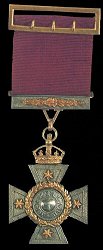
The New Zealand Cross was introduced in 1869 during the New Zealand Wars in New Zealand. The wars were fought between natives of New Zealand, the Māori, and forces raised by European settlers known as Pākehā assisted by British troops.
Waiouru is a small town in the Ruapehu District, in New Zealand's Manawatū-Whanganui region. It is located on the south-eastern North Island Volcanic Plateau, 130 km (81 mi) north of Palmerston North and 25 kilometres south-east of Mount Ruapehu. The town had a population of 765 in the 2018 census.

Mount Hikurangi is a 1,752 m (5,748 ft) peak in the eastern corner of New Zealand's North Island, about 80 kilometres (50 mi) north of Gisborne, and 50 kilometres (31 mi) southwest of the East Cape Lighthouse. On a spur of the Raukumara Range in the Waiapu Valley, it is the North Island's highest non-volcanic peak.

Ngāti Tūwharetoa is an iwi descended from Ngātoro-i-rangi, the priest who navigated the Arawa canoe to New Zealand. The Tūwharetoa region extends from Te Awa o te Atua at Matatā across the central plateau of the North Island to the lands around Mount Tongariro and Lake Taupō.

Te Ara: The Encyclopedia of New Zealand is an online encyclopedia established in 2001 by the New Zealand Government's Ministry for Culture and Heritage. The web-based content was developed in stages over the next several years; the first sections were published in 2005, and the last in 2014 marking its completion. Te Ara means "the pathway" in the Māori language, and contains over three million words in articles from over 450 authors. Over 30,000 images and video clips are included from thousands of contributors.

Henare Tomoana was a prominent Māori leader and politician from the Hawke's Bay area in the North Island, New Zealand. He was of Ngāti Kahungunu and Ngāti Te Whatu-i-Apiti tribal lineage. In 1879 he was elected to the New Zealand Parliament for the Eastern Maori electorate, and in 1898 was appointed to the New Zealand Legislative Council. He was a convenor of Te Kotahitanga, the movement for an independent Māori Parliament.

Tikitiki is a small town in Waiapu Valley on the north bank of the Waiapu River in the Gisborne Region of the North Island of New Zealand. The area in which the town resides was formerly known as Kahukura. By road, Tikitiki is 145 km (90 mi) north-northeast of Gisborne, 20 km (12 mi) northeast by north of Ruatoria, and 24 km (15 mi) south by east of Te Araroa. The name of the town comes from the full name of Māui, Māui-tikitiki-a-Taranga. State Highway 35 passes through the town at the easternmost point of the New Zealand state highway network.

Rawiri Puhirake was a New Zealand tribal leader. Of Māori descent, he identified with the Ngāi Te Rangi iwi. He was killed in the Battle of Te Ranga.
Captain Gilbert Mair was a New Zealand surveyor, interpreter, soldier and public servant. He was born in Whangarei, Northland, New Zealand on 10 January 1843, the son of an early trader, also named Gilbert Mair. His brother was Major William Gilbert Mair.

Fanny Rose Howie, also known by her stage name Te Rangi Pai, was a New Zealand singer and composer. Of Māori descent, she identified with the iwi of Ngāti Porou and Te Whānau-ā-Apanui. The lullaby "Hine E Hine" is her most famous composition, and she was well-known in Britain as a singer of opera and popular music from 1901 to 1905.
This timeline sets out intertribal battles involving Māori people in what is now New Zealand.

Putiki is a settlement in the Whanganui District and Manawatū-Whanganui region of New Zealand's North Island, located across the Whanganui River from the Wanganui township. It includes the intersection of State Highway 3 and State Highway 4.
Whiti-patatō was a rangatira (chieftain) of Ngāti Raukawa, based at Whare-puhunga in the Waikato region of New Zealand, who led an attack on Ngāti Tūwharetoa to avenge the death of the Ngāti Raukawa rangatira, Te Ata-inutai, probably in the mid-seventeenth century.
Te Rangi-ita was a Maori ariki (chieftain) of Ngāti Tūwharetoa from the region around Lake Taupō, New Zealand. He participated with bravery in the Ngāti Tama-Ngāti Tūwharetoa War, fought off an invasion by the Ngāti Raukawa chieftain Te Ata-inutai, and forged a peace through his marriage to Te Ata-inutai's daughter, Waitapu. Through their children, he is an ancestor of many hapu of Ngāti Tūwharetoa, including Ngāti Te Rangiita, the main hapu on the south shore of Lake Taupō, where the town of Te Rangi-ita is named after him. He probably lived in the early seventeenth century.
