Orchard Hills, Irvine, California

Last updated
Orchard Hills
Cólinas del Huérto (Spanish)
Community of Irvine, California
Community of Orchard Hills
Orchard Hills.png
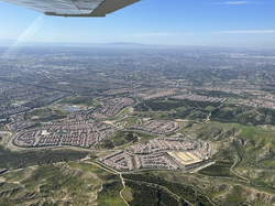
Orchard Hills from the air, looking west.
City Irvine, CA
Area
  Total21.46 km2 (8.29 sq mi)
Population
 (2019)[ dubious ]
  Total990
  Density829.62/km2 (2,148.7/sq mi)
  population percent
0.00363044291 % of Irvine
Demonym(s) Orchardian, Irvinian
GDP
 (PPA; 2021)
  Per capita$107,000 USD
Website Orchard Hills Irvine Company Page

Orchard Hills is one of the master-planned communities of Irvine, California. To the east, it borders Limestone Canyon Regional Park, and to the west lies North Tustin, California. Located between 261 Highway and 241 Highway, the community is home to the Rattlesnake and Syphon reservoirs.

Contents

History

Orchard Hills was historically inhabited by the Chumash, Alliklik, Kitanemuk, Serrano, Gabrielino Luiseno Cahuilla, and the Kumeyaay tribes, [1] predominantly the Gabrieleno Tribes who are thought to have been Uto-Aztecan speakers. Some researchers believe that the Aztecs descended from California. Orchard Hills is near Irvine Ranch, so it is expected that Gabrieleño farmers and Hunter-gatherers likely farmed acorns, mesquite, Prickly-Pear Cactus, chia seeds, wild cherry, white sage, among other fruits. [2]

European colonization

From the 17th century to the early 19th century, California was under Spanish rule as Alta California. During this period, the state was limited to trading outposts, villages, forts, and most notably, the Spanish missions in California, which were erected by Junipero Serra. The mission closest to Orchard Hills is San Juan Capistrano, which was founded in 1776. [3]

Mexican-American war

One of the implications of the Mexican–American War was the Bear Flag Revolt, which disrupted native activity in the area near Orchard Hills. [4]

Demographics

Orchard Hills has a population of 990.[ dubious ] [5] [ failed verification ] Orchard Hills' majority group are Asian Americans who are 68 percent of the population, the rest being 24.1 percent White and 6.7 percent Hispanic/Latino. A majority of Orchard Hills residents are female. In addition, Orchard Hills has the highest percent of children out of the neighborhoods of Irvine. [6]

Orchard Hills Race/Ethnicity Chart OrchardHillsDemographics.png
Orchard Hills Race/Ethnicity Chart

Schools

The local public school of Orchard Hills is Orchard Hills School, belonging to the Tustin Unified School District, and the school mascot is a hawk. Orchard Hills School offers various programs such as robotics, AVID 7/8, and various others. [7]

Notable places

Pavilions

The pavilions is a shopping centre in the Orchard Hills plaza. [8]

Settlers Park

Settlers Park is a stable attraction, being visited by many of the students of Orchard Hills School after school.

See also

Related Research Articles

<span class="mw-page-title-main">Tongva</span> Indigenous people of the Los Angeles Basin and Channel Islands in California

The Tongva are an Indigenous people of California from the Los Angeles Basin and the Southern Channel Islands, an area covering approximately 4,000 square miles (10,000 km2). In the precolonial era, the people lived in as many as 100 villages and primarily identified by their village rather than by a pan-tribal name. During colonization, the Spanish referred to these people as Gabrieleño and Fernandeño, names derived from the Spanish missions built on their land: Mission San Gabriel Arcángel and Mission San Fernando Rey de España. Tongva is the most widely circulated endonym among the people, used by Narcisa Higuera in 1905 to refer to inhabitants in the vicinity of Mission San Gabriel. Some people who identify as direct lineal descendants of the people advocate the use of their ancestral name Kizh as an endonym.

<span class="mw-page-title-main">Tustin, California</span> City in Orange County, California, US

Tustin is a city located in Orange County, California, United States, within the Los Angeles metropolitan area. In 2020, Tustin had a population of 80,276. The city does not include the unincorporated community of North Tustin.

<span class="mw-page-title-main">Yaqui</span> Indigenous group in Mexico and the United States

The Yaqui, Hiaki, or Yoeme, are an Indigenous people of Mexico and Native American tribe, who speak the Yaqui language, a Uto-Aztecan language.

<span class="mw-page-title-main">Uto-Aztecan languages</span> North American language family

Uto-Aztecan, Uto-Aztekan is a family of indigenous languages of the Americas, consisting of over thirty languages. Uto-Aztecan languages are found almost entirely in the Western United States and Mexico. The name of the language family was created to show that it includes both the Ute language of Utah and the Nahuan languages of Mexico.

<span class="mw-page-title-main">California State Route 261</span> State highway toll road in Orange County, California, United States

State Route 261 (SR 261) is a state highway that forms part of the Eastern Transportation Corridor toll road system in Orange County, California. It runs from Walnut Avenue and Jamboree Road in Irvine north to SR 241. North of this interchange, SR 241 becomes part of the Eastern Transportation Corridor. SR 261 parallels Jamboree Road for its entire length. SR 261 does not directly connect with I-5 in Irvine, as Jamboree Road and other streets must be used to make the connection.

The Big Pine Band of Owens Valley Paiute Shoshone Indians of the Big Pine Reservation are a federally recognized tribe of Mono and Timbisha Indians in California.

<span class="mw-page-title-main">Acaxee</span>

The Acaxee or Acaxees were a tribe or group of tribes in the Sierra Madre Occidental in eastern Sinaloa and NW Durango. They spoke a Taracahitic language in the Southern Uto-Aztecan language family. Their culture was based on horticulture and the exploitation of wild animal and plant life. They are now extinct as an identifiable ethnic group.

<span class="mw-page-title-main">Mono language (California)</span> Native American language of California

Mono is a Native American language of the Numic group of Uto-Aztecan languages, the ancestral language of the Mono people. Mono consists of two dialects, Eastern and Western. The name "Monachi" is commonly used in reference to Western Mono and "Owens Valley Paiute" in reference to Eastern Mono. In 1925, Alfred Kroeber estimated that Mono had 3,000 to 4,000 speakers. As of 1994, only 37 elderly people spoke Mono as their first language. It is classified as critically endangered by UNESCO. It is spoken in the southern Sierra Nevada, the Mono Basin, and the Owens Valley of central-eastern California. Mono is most closely related to Northern Paiute; these two are classified as the Western group of the Numic branch of the Uto-Aztecan language family.

The Hahamog'na, commonly anglicized to Hahamongna and spelled Xaxaamonga in their native language, are a tribe of the Tongva people of California. Their language belongs to the Uto-Aztecan family.

<span class="mw-page-title-main">Arnold O. Beckman High School</span> Public school in the United States

Arnold O. Beckman High School is a public school in Irvine, California, United States, serving 3,013 students from grades 9 through 12. The original $94 million facility was opened on August 30, 2004. The World Languages Building - a new, $17 million, two-story, 30,000-square-foot facility - was unveiled on September 1, 2015. The school is commonly known as Beckman and is named after Arnold Orville Beckman: a scientist, chemist, and philanthropist famed for inventing the pH scale during his tenure at Caltech and funding Silicon Valley's first semiconductor company.

<span class="mw-page-title-main">Tustin Unified School District</span> School district in California

Tustin Unified School District was created from the 1972 voter-approved unification of the Tustin Elementary School District and the Tustin Union High School District. It is located in Tustin, a city in Orange County, California. Its district territory comprises Tustin, the unincorporated community of North Tustin, and parts of the cities of Irvine and Santa Ana. It has 18 elementary schools, five middle schools, four high schools, one K-8 school, and one adult school.

<span class="mw-page-title-main">Irvine, California</span> City in California, United States

Irvine is the largest city and a master-planned city in central Orange County, California, United States, in the Los Angeles metropolitan area. The Irvine Company started developing the area in the 1960s and the city was formally incorporated on December 28, 1971. The 66-square-mile (170 km2) city had a population of 307,670 at the 2020 census; it is the 63rd most populous city in the United States.

<span class="mw-page-title-main">Northern Paiute language</span> Numic language spoken in western US

Northern Paiute, endonym Numu, also known as Paviotso, is a Western Numic language of the Uto-Aztecan family, which according to Marianne Mithun had around 500 fluent speakers in 1994. It is closely related to the Mono language.

<span class="mw-page-title-main">Acjachemen</span> Native American people in California

The Acjachemen are an Indigenous people of California. Published maps often identify their ancestral lands as extending from the beach to the mountains, south from what is now known as Aliso Creek in Orange County to the Las Pulgas Canyon in the northwestern part of San Diego County. However, sources also show that Acjachemen people shared sites with other Indigenous nations as far north as Puvunga in contemporary Long Beach.

<span class="mw-page-title-main">Cold Springs Rancheria of Mono Indians of California</span> Indian tribe in California, United States

The Cold Springs Rancheria of Mono Indians of California is a federally recognized tribe of Mono Native Americans. Cold Springs Rancheria is the tribe's reservation, which is located in Fresno County, California. As of the 2010 Census the population was 184.

Pasadena is a city in Los Angeles County, California, United States. Founded in 1874 and incorporated in 1886, the city is famous for its colorful history and for the hosting of both the Tournament of Roses Parade and the annual Rose Bowl game football game. It is also the home of the world-renowned California Institute of Technology (Caltech) and Jet Propulsion Laboratory (JPL)

<span class="mw-page-title-main">Bridgeport Paiute Indian Colony of California</span> Indian tribe in California, United States

The Bridgeport Indian Colony of California, formerly known as the "Bridgeport Paiute Indian Colony of California", is a federally recognized tribe of Northern Paiute Indians in Mono County, California, United States.

The Paiute-Shoshone Indians of the Lone Pine Community of the Lone Pine Reservation is a federally recognized tribe of Mono and Timbisha Native American Indians near Lone Pine in Inyo County, California. They are related to the Owens Valley Paiute.

Frances Jane Hassler Hill was an American anthropologist and linguist who worked extensively with Native American languages of the Uto-Aztecan language family and anthropological linguistics of North American communities.

The Municipal Water District of Orange County, commonly known by the acronym MWDOC, is a wholesale water provider, water resource development and planning agency., water-centric information, education, emergency planning, and conservation resource hub for nearly 3.2 millionOrange County, California residents, and businesses. Local water supply sources meet only about half of the region's total water needs. To fulfill the remaining demand, MWDOC buys imported water from the California State Water Project in northern California and the Colorado River through the Metropolitan Water District of Southern California (Metropolitan). MWDOC delivers water to its 27 member agencies - made up of both water districts and city water departments - who then, in turn, provide retail water service to the public.

References

  1. "California Indian History – California Native American Heritage Commission".
  2. "From Prickly Pear to Wild Cherry: Indigenous Foods of California". KCET. November 14, 2016.
  3. "History".
  4. "Captain John Charles Fremont and the Bear Flag Revolt". www.militarymuseum.org.
  5. "Orchard Hills, CA Household Income, Population & Demographics | Point2".
  6. "The Demographic Statistical Atlas of the United States - Statistical Atlas". statisticalatlas.com.
  7. "Orchard Hills - Tustin Unified School District". www.tustin.k12.ca.us.
  8. Pavillions (2023-03-02). "Pavillions OH". local.pavilions.com. Retrieved 2023-03-02.