The red-necked grebe is a migratory aquatic bird found in the temperate regions of the northern hemisphere. Its wintering habitat is largely restricted to calm waters just beyond the waves around ocean coasts, although some birds may winter on large lakes. Grebes prefer shallow bodies of fresh water such as lakes, marshes or fish-ponds as breeding sites.

The horned grebe or Slavonian grebe is a relatively small and threatened species of waterbird in the family Podicipedidae. There are two subspecies, P. a. auritus, which breeds in Eurasia, and P. a. cornutus, which breeds in North America. The Eurasian subspecies is distributed over most of northern Europe and northern Asia, breeding from Iceland east to the Russian Far East. The North American subspecies spans most of Canada and some of the United States. A small population was cited in Greenland in 1973, but is not mapped or further mentioned by subsequent authors.

The black-necked grebe or eared grebe is a member of the grebe family of water birds. It was described in 1831 by Christian Ludwig Brehm. Its breeding plumage features distinctive ochre-coloured feathers which extend behind its eye and over its ear coverts. The rest of the upper parts, including the head, neck, and breast, are coloured black to blackish brown. The flanks are tawny rufous to maroon-chestnut, and the abdomen is white. In its non-breeding plumage, this bird has greyish-black upper parts, including the top of the head and a vertical stripe on the back of the neck. The flanks are also greyish-black. The rest of the body is a white or whitish colour. The juvenile has more brown in its darker areas. This species is present in parts of Africa, Eurasia, and the Americas.

The pied-billed grebe is a species of the grebe family of water birds primarily found in ponds throughout the Americas.

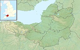
Frome is a town and civil parish in Somerset, England, on uneven high ground at the eastern end of the Mendip Hills and on the River Frome, 13 miles (21 km) south of Bath. The population of the parish was 28,559 in 2021.

Henrys Lake is a small, shallow alpine lake in the western United States, in eastern Idaho. Approximately 8 square miles (21 km2) in area, at 4 miles (6.4 km) in length and 2 miles (3.2 km) in width, its surface elevation is 6,472 ft (1,973 m) above sea level.

Buckland Dinham is a small village near Frome in Somerset, England. The village has a population of 381. The village's main industry is farming, but the village is also a dormitory village for the nearby cities of Bath and Bristol.

The Cotswold Water Park is the United Kingdom's largest marl lake system, straddling the Wiltshire–Gloucestershire border, north-west of Cricklade and south of Cirencester. There are 180 lakes, spread over 42 square miles (110 km2).

The Möhne Reservoir, or Moehne Reservoir, is an artificial lake in North Rhine-Westphalia, some 45 km east of Dortmund, Germany. The lake is formed by the damming of two rivers, Möhne and Heve, and with its four basins stores as much as 135 million cubic metres of water.
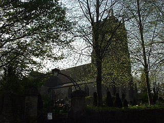
Nunney is a village and civil parish in the English county of Somerset. It is located 3 miles (5 km) south-west of Frome and the parish includes the hamlet of Holwell.

Witham Friary is a small English village and civil parish located between the towns of Frome and Bruton in the county of Somerset. It is in the Cranborne Chase and West Wiltshire Downs Area of Outstanding Natural Beauty and the ancient Forest of Selwood.

Mells is a village and civil parish in Somerset, England, near the town of Frome.

Hemington is a village and civil parish 5.5 miles (8.9 km) north west of Frome, in the Mendip district of Somerset, England. It is located just off the A366 between Trowbridge and Radstock. The parish includes the villages of Hardington, Faulkland and Foxcote.

Lullington is a village and civil parish in the area of the Somerset Council unitary authority in England. The village lies east of Beckington, on the other side of the Mells River, and is 2.5 miles (4.0 km) north east of Frome.
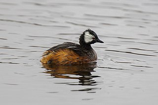
The white-tufted grebe, also known as Rolland's grebe, is a species of grebe in the family Podicipedidae. Found in the southern and western South America, its natural habitat is freshwater lakes, ponds and sluggish rivers and streams.
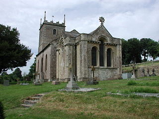
Marston Bigot is a small village and former civil parish, now in the parish of Trudoxhill in the Somerset district, in the ceremonial county of Somerset, England. It is near Nunney and 3 miles (5 km) south of Frome. In 1931 the parish had a population of 117.
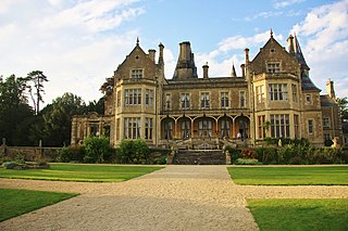
Orchardleigh is a country estate in Somerset, approximately two miles north of Frome, and on the southern edge of the village of Lullington. The privately-owned estate comprises a Victorian country house, Orchardleigh Lake with its island church, and an 18-hole golf course. It operates as a wedding and events venue.

The Church of St Mary is a 13th-century church in the grounds of the Orchardleigh Estate in Somerset, England.

The Champneys, later Mostyn-Champneys Baronetcy, of Orchardleigh in the County of Somerset, was a title in the Baronetage of Great Britain. It was created on 12 January 1767 for Thomas Champneys, subsequently High Sheriff of Somerset from 1775 to 1776. He owned the Orchardleigh estate near Frome and other English properties. In 1771 he inherited from his uncle, Anthony Swymmer a sizeable plantation: Nutt's River, in the parish of St Thomas in the East, Surrey, close to Morant Bay, Jamaica. This estate produced sugar, rum and livestock, mainly cattle. In 1810, 241 slaves were counted as part of the property.
The Anglican Church of All Saints in Rodden, Somerset, England, was built in 1640. It is a Grade II* listed building.

